Donate to the 2024 Spring Campaign to help rebuild the UAC website.

Forecast for the Abajos Area Mountains

Eric Trenbeath
Issued by Eric Trenbeath for
Saturday, February 26, 2022
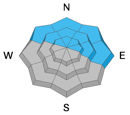
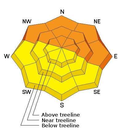
The avalanche danger is CONSIDERABLE and human triggered avalanches are likely on steep slopes that face the north half of the compass. Recent and wind drifted snow has piled up on a weak layer of loose sugary snow creating dangerous avalanche conditions in these areas and steep, notherly facing slopes should be avoided. The danger is generally MODERATE on steep slopes facing the south side of the compass.
Low
Moderate
Considerable
High
Extreme
Learn how to read the forecast here
Weather and Snow
Temperatures are in negative territory this morning and though it's going to be a beautiful day you may not want to rush out the door until it warms up a bit! Today we'll see sunny skies, light NW winds and temps at 10,000' barely climbing out of the upper teens. A weak shortwave will bring cloudy skies to the area on Sunday night. Dry and slowly but steadily warming conditions are on tap through mid-week. A weak low pressure system moves on shore in the Pacific Northwest on Thursday bringing a slight chance for snow showers on Friday but don't hold your breath for this one.
Snow totals and temps at Buckboard Flat (8924')
Snow totals and temps at Camp Jackson (8858')
In my travels on Thursday I found excellent powder snow and sensitive, dangerous avalanche conditions. Heading up North Creek I was able to remotely trigger this avalanche as I passed underneath the slope. This is an obvious red flag sign of instability and areas that have deeper snow, will produce deeper and more dangerous avalanches.
Avalanche Problem #1
Persistent Weak Layer
Type
Location
Likelihood
Size
Description
Recent and wind drifted snow has piled up on a variety of old snow surfaces and faceted, weak layer combinations. The weakest snow can be found on sheltered, northerly aspects, and this is where you are most likely to trigger an avalanche failing on a buried persistent weak layer. The only safe strategy at this time is avoidance of steep slopes facing NW-N-NE-E.
Avalanche Problem #3
New Snow
Type
Location
Likelihood
Size
Description
Human triggered avalanches within the new snow remain possible on steep slopes on all aspects. These will come in the form of either loose snow or sensitive soft slabs. South facing slopes have less snow on them because of prevailing winds over the last several days, but any steep slope with more than about 8" of snow should be considered suspect.
General Announcements
Who's up for some free avalanche training? Get a refresher, become better prepared for an upcoming avalanche class, or just boost your skills. Go to https://learn.kbyg.org/ and scroll down to Step 2 for a series of interactive online avalanche courses produced by the UAC.
This forecast is from the U.S. Forest Service, which is solely responsible for its content. This forecast describes general avalanche conditions and local variations always occur.