
| During the month of April, Mark Miller will donate $75 to the charity of your choice (5 to chose from, including the Utah Avalanche Center!) Mark Miller Subaru has raised over $300k in the previous 6 Do Good Feel Good events. More Info here |  |
| During the month of April, Mark Miller will donate $75 to the charity of your choice (5 to chose from, including the Utah Avalanche Center!) Mark Miller Subaru has raised over $300k in the previous 6 Do Good Feel Good events. More Info here | |
| Advisory: Uintas Area Mountains | Issued by Craig Gordon for Wednesday - November 20, 2013 - 6:38am |
|---|


|
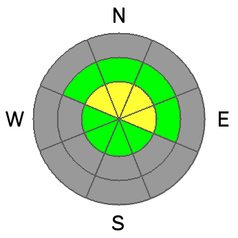
bottom line The avalanche danger is MODERATE today and human triggered avalanches are possible on steep, upper elevation, north facing slopes, especially those that had pre-existing snow prior to last weekends storm. Todays avalanches have the possibility of breaking to the ground, creating an unmanageable and possibly season ending situation. In terrain with no old snow prior to last weekends storm the avalanche danger is generally LOW.
|
 |
current conditions A moist westerly flow the past few days ushered in a couple inches of snow with temperatures in the low 30's. Currently, west and southwest winds are blowing in the teens and mid 20's along the high ridges. It's thin out there with riding and turning options limited to grassy, rock free meadows and roads. Click here for current winds, temperatures, and snowfall throughout the range.
|
 |
recent activity
Two avalanches triggered from a distance on Sunday near Currant Creek and Hoyt Peak. Both slides occurred on upper elevation north facing terrain that retained old October snow.
|
| type | aspect/elevation | characteristics |
|---|

|
|
LIKELIHOOD
 LIKELY
UNLIKELY
SIZE
 LARGE
SMALL
TREND
 INCREASING DANGER
SAME
DECREASING DANGER
|
|
description
The snowpack is slowly adjusting to the weekend storm, but we're still getting reports of cracking and collapsing, especially in upper elevation, north facing terrain. Remember- these are the slopes that retained snow since October. The old snow grew weak and sugary during the early November dryspell and now there's a cohesive slab resting on top. Once triggered, today's avalanches could be larger than you might expect given the early season conditions, and they'll be packing heat... easily knocking you off your skis, board, or sled and taking you for a nasty ride through rocks and stumps barely hidden under our shallow snowpack. The big ticket for today is heading to a rock free meadow that had no old snow prior to the big weekend storm.
Thanks to JG for this great snowpit write up.
|
 |
weather Another weak, but moist system brings light snow to the range with temperatures climbing into the low 30's. Winds remain west and southwesterly today blowing in the low 20's along the high ridges. A cold front slides through the region tonight through Thursday morning, bringing a better shot of snow with accumulations in the 6"-8" range. Drier air moves in behind the front during the day Thursday, giving us clearing skies and slightly cooler temperatures through the weekend. |
| general announcements Remember your information can save lives. If you see anything we should know about, please participate in the creation of our own community avalanche advisory by submitting snow and avalanche conditions. You can call me directly at 801-231-2170, email [email protected], or email by clicking HERE This is a great time of year to schedule a free avalanche awareness presentation for your group or club. You can contact me at 801-231-2170 or email [email protected] Donate to your favorite non-profit –The Friends of the Utah Avalanche Center. The UAC depends on contributions from users like you to support our work. The information in this advisory is from the US Forest Service which is solely responsible for its content. This advisory describes general avalanche conditions and local variations always occur. I will update this advisory by 7:00 AM on Saturday Nov. 23, 2013 |


_0.jpg)


