| During the month of April, Mark Miller will donate $75 to the charity of your choice (5 to chose from, including the Utah Avalanche Center!) Mark Miller Subaru has raised over $300k in the previous 6 Do Good Feel Good events. More Info here |  |
| During the month of April, Mark Miller will donate $75 to the charity of your choice (5 to chose from, including the Utah Avalanche Center!) Mark Miller Subaru has raised over $300k in the previous 6 Do Good Feel Good events. More Info here | |
| Advisory: Skyline Area Mountains | Issued by Craig Gordon for Friday - December 27, 2013 - 6:50pm |
|---|

|
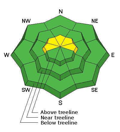
bottom line A MODERATE avalanche danger exists on steep, upper elevation slopes, facing the north half of the compass and human triggered avalanches are possible. While not widespread and limited to a small portion of the range, once initiated, slides may break deeper and wider than you expected, particularly on steep, rocky slopes where strong snow overlays weak, sugary snow..
|
 |
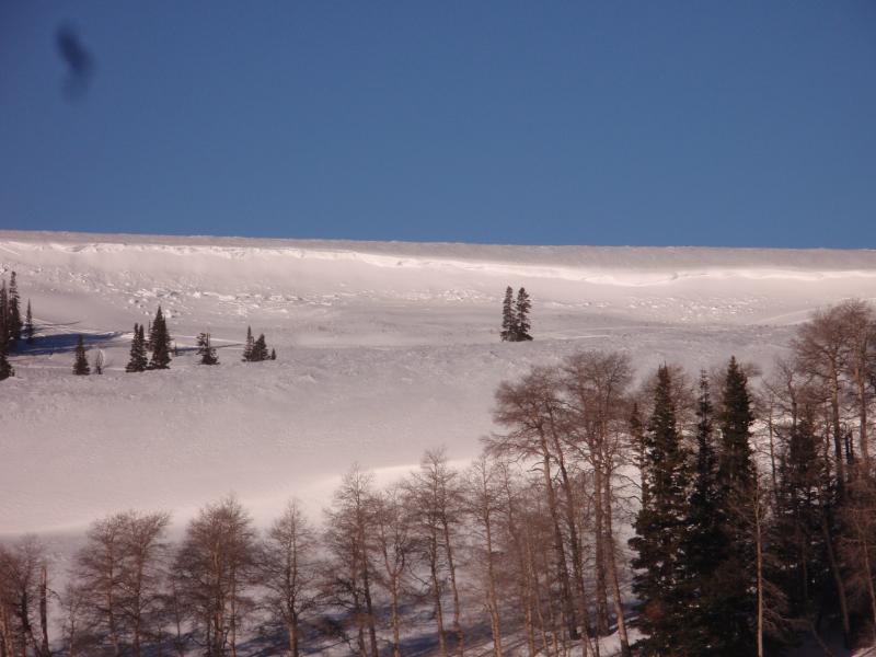
current conditions Conditions are slowly improving and the terrain near the summit is starting to fill in somewhat. The riding might not be epic, but it'll be a beautiful weekend on the Skyline none-the-less. Get out of the cold valleys and head to the mountains where you'll be greeted with clear skies, warm temperatures, and light winds.
The Big Drift is looking a little more driftier these days, but nowhere near as white as it should be for this time of year.
|
 |
recent activity
Shallow soft slabs can be seen on the leeward side of ridges near the summit. |
| type | aspect/elevation | characteristics |
|---|

|

|
LIKELIHOOD
 LIKELY
UNLIKELY
SIZE
 LARGE
SMALL
TREND
 INCREASING DANGER
SAME
DECREASING DANGER
|
|
description
The Monday/Tuesday storm helped lay down a coat of new paint, but it didn't change the avalanche danger dramatically. A few shallow slides have been spotted in the usual places... steep, leeward slopes, especially in the wind zone near the summit. Manageable in size and depth, I think most have settled out, but as always look for and avoid any steep slope with fresh wind drifted snow. The bigger danger this weekend is triggering an avalanche that breaks to weak snow near the ground. Sure, you'd really have to go hunting for this avalanche dragon, but it's not totally elusive. The most likely place to trigger a slide larger than you might expect is steep, rocky, upper elevation terrain, especially on slopes where strong feeling snow rests on top of weak sugary snow. |
 |
weather Partly cloudy skies and a flurry or two develop on Saturday as a weak storm slides through the region. High pressure builds afterwards, providing sunny skies, temperatures climbing into the upper 30's, and light winds. There are no big storms in sight. |
| general announcements Remember your information can save lives. Please let us and the rest of the community know what you are seeing out there by submitting snow and avalanche conditions. This is a great time of year to schedule a free avalanche awareness presentation for your group or club. Contact either Craig Gordon or Brett Kobernik by emailing us: Donate to your favorite non-profit –The Utah Avalanche Center. The UAC depends on contributions from users like you to support our work. Benefit the Utah Avalanche Center when you buy or sell on ebay - set the Utah Avalanche Center as a favorite non-profit in your ebay account here and click on ebay gives when you buy or sell. You can choose to have your seller fees donated to the UAC, which doesn't cost you a penny. Utah Avalanche Center mobile app - Get your advisory on your iPhone along with great navigation and rescue tools. The information in this advisory is from the US Forest Service which is solely responsible for its content. This advisory describes general avalanche conditions and local variations always occur. This advisory will be updated by 8:00 PM January 3rd. |


.jpg)