| Please join us at the 23rd annual Black Diamond Fall Fundraiser Party Thursday Sept 15. Tickets are on sale now here, at the Black Diamond store & at REI. Special bonus raffle for online ticket purchasers! |
| Please join us at the 23rd annual Black Diamond Fall Fundraiser Party Thursday Sept 15. Tickets are on sale now here, at the Black Diamond store & at REI. Special bonus raffle for online ticket purchasers! |
| Advisory: Logan Area Mountains | Issued by Toby Weed for Saturday - March 19, 2016 - 6:02am |
|---|

|
bottom line MODERATE (level 2): Heightened wind slab and cornice fall conditions exist, and triggered avalanches are possible in steep drifted terrain. The danger of loose wet avalanches entraining new snow will rise rapidly on sunny slopes as the fresh snow is warmed and it becomes saturated. Evaluate the snow and terrain carefully, avoid drifted terrain, and stay off of and out from under steep sunny slopes in the heat of the day.
|
 |
special announcement ***Please take time to complete a quick survey that will help us better serve you in the future. HERE
|
 |
current conditions The Bear River Range picked up a few feet of fresh powder this week, and we've found very nice deep powder riding conditions. Powerful March sun certainly got to sunny slopes yesterday, but the snow stayed nice and dry on north facing slopes at all elevations. The powder is now settled and the glittery surface re-crystallized and fast. Forecast temperatures will be around 10 degrees warmer today than yesterday, and solar heating with the high March sun angle will dampen the fresh surface snow on sunny slopes creating heightened wet avalanche conditions. The Tony Grove Snotel at 8400' reports 18 degrees this morning and 97 inches of total snow containing 106% of average water for the date. I'm reading 14 degrees at the 9700' CSI Logan Peak weather station, but the wind sensor is still rimed. Mt Ogden shows northwest winds averaging around 20 mph.
|
 |
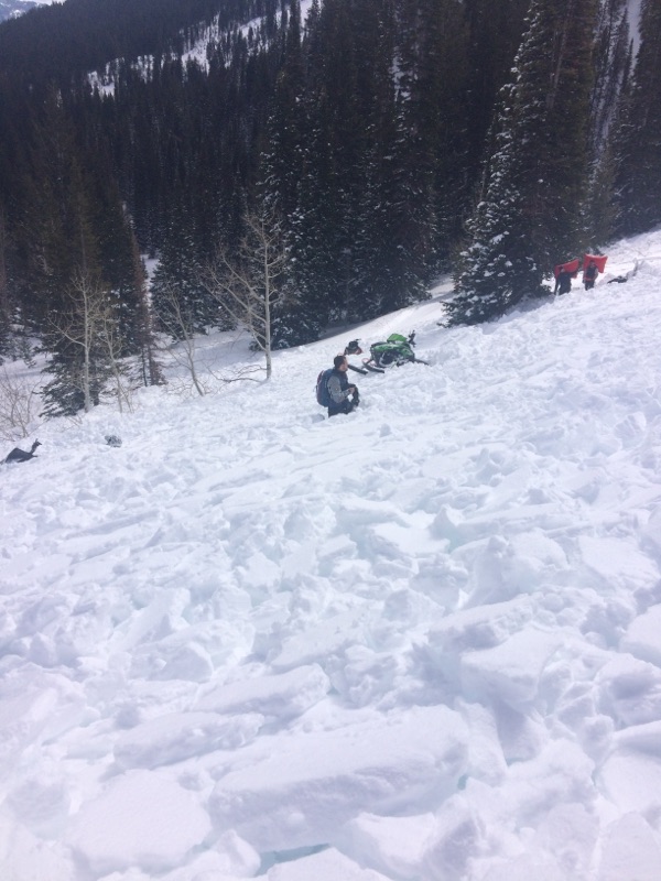
recent activity Local trail heads are overflowing and riders tested numerous steep slopes in the Central Bear River Range in the past couple days, but certainly not without incident.
Four riders in a party of five were caught, with one fully buried, in a sizable wind slab avalanche near White Pine Lake yesterday, (3-18-16)
|
| type | aspect/elevation | characteristics |
|---|

|
|
LIKELIHOOD
 LIKELY
UNLIKELY
SIZE
 LARGE
SMALL
TREND
 INCREASING DANGER
SAME
DECREASING DANGER
|
|
description
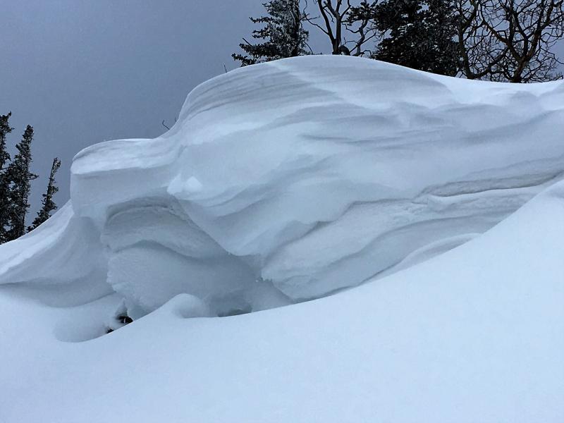
Sustained westerly wind, sometimes during periods of heavy snowfall during the work week created heightened wind slab and cornice fall conditions in drifted terrain. A few natural avalanches occurred in the Tony Grove Area, and we have reports of a handful of good sized wind slabs triggered by sledders in the past couple days in the Central Bear River Range.
|
| type | aspect/elevation | characteristics |
|---|

|
|
LIKELIHOOD
LIKELY
UNLIKELY
SIZE
LARGE
SMALL
TREND
 INCREASING DANGER
SAME
DECREASING DANGER
|
|
description
The powerful March sun will be out in force in the mountains again today, and daytime temperatures will be around 10 degrees warmer than yesterday's. Solar warming will moisten the fresh snow causing it to become sticky. Loose wet avalanches entraining the copious fresh snow are possible and may become likely on sunny slopes. Debris piles could be fairly large especially on sustained steep slopes. Heat related slab avalanches involving the new snow are possible in some steep sunny areas. The danger of wet avalanches is likely to rise and become more widespread with increasing mountain temperatures over the weekend.
|
 |
weather High pressure over the region ensures fair and sunny weather in the mountains this weekend. Cooler and wetter weather is expected Monday and through the first part of next week. Expect lots of sun and high temperatures at 9000' around 40 degrees, with a light and calming north wind. Temperatures should drop a few degrees below freezing overnight, with calm winds becoming light and easterly. Expect sunny weather again on Sunday, with high temperatures climbing to around 50 degrees! |
| general announcements The National Avalanche Center recently completed an animated tutorial on the North American Avalanche Danger Scale. HERE Please submit snow and avalanche observations from your ventures in the backcountry HERE. You can call us at 801-524-5304 or email HERE, or include #utavy in your Instagram or Tweet us @UAClogan. To report avalanche activity in the Logan Area or to contact the local avalance forecaster call me, Toby, at 435-757-7578. We'll update this advisory throughout the season on Monday, Wednesday, Friday, and Saturday mornings by about 7:30 This advisory is produced by the U.S.D.A. Forest Service, which is solely responsible for its content. It describes only general avalanche conditions and local variations always exist.
|