| Please join us at the 23rd annual Black Diamond Fall Fundraiser Party Thursday Sept 15. Tickets are on sale now here, at the Black Diamond store & at REI. Special bonus raffle for online ticket purchasers! |
| Please join us at the 23rd annual Black Diamond Fall Fundraiser Party Thursday Sept 15. Tickets are on sale now here, at the Black Diamond store & at REI. Special bonus raffle for online ticket purchasers! |
| Advisory: Logan Area Mountains | Issued by Toby Weed for Saturday - January 30, 2016 - 7:22am |
|---|


|
bottom line HIGH (level 4): Avoid travel in backcountry avalanche terrain. We recommend you stay off of and out from under obvious and historic avalanche paths and slopes steeper than about 30 degrees at all elevations. Heavy snow, strong southwest winds, and a bit of rain-on-snow overnight caused the avalanche danger to rise significantly. Very dangerous avalanche conditions exist with both human-triggered and natural avalanches likely. Continuing heavy snowfall and northwest winds during the day today will probably cause the danger to increase further and become more widespread.
|
 |
avalanche warning HE FOLLOWING MESSAGE IS TRANSMITTED AT THE REQUEST OF THE FOREST SERVICE UTAH AVALANCHE CENTER. THE FOREST SERVICE UTAH AVALANCHE CENTER IN SALT LAKE CITY HAS ISSUED A BACKCOUNTRY AVALANCHE WARNING. * TIMING...THROUGH 6 AM SUNDAY MORNING. * AFFECTED AREA...ALL THE NORTHERN MOUNTAINS OF UTAH. * AVALANCHE DANGER...IS HIGH...NATURAL AND HUMAN TRIGGERED SLIDES ARE CERTAIN TODAY. * IMPACTS...DANGEROUS AVALANCHE CONDITIONS EXIST. TRAVELERS SHOULD AVOID STEEP SLOPES AND AVALANCHE RUNOUT ZONES...INCLUDING LOW ELEVATION SLOPES. BACKCOUNTRY TRAVEL IN AVALANCHE TERRAIN IS NOT RECOMMENDED. BACKCOUNTRY TRAVELERS SHOULD CONSULT WWW.UTAHAVALANCHECENTER.ORG OR CALL 1-888-999-4019 FOR MORE DETAILED INFORMATION. |
 |
current conditions Very dangerous conditions exist in the backcountry, and people should avoid travel in avalanche terrain today. We recommend you stay off of and out from under obvious or historic avalanche paths and slopes steeper than about 30 degrees. Natural and human triggered avalanches are likely. The temperature is 23 degrees and this morning there's several inches of heavy new snow (with a gain of 1.5 inches of water in the last 24 hours) at the 8400' Tony Grove Snotel. I'm reading 75 inches of total snow, containing 107% of average water content for the date. The 9700' CSI Logan Peak weather station reports 17 degrees and fairly strong southwest winds overnight, currently the wind is from the northwest averaging about 18 mph. Most stations in the range are reading between 1.3-1.5" of water in the past 24 hrs. It'll be a good day to ride on established trails and in lower angled meadows, but you should avoid and stay out from under steep hills. Beaver Mountain will be a great non-backcountry powder option for skiers and riders today, with 8" of new snow reported overnight.
|
 |
recent activity
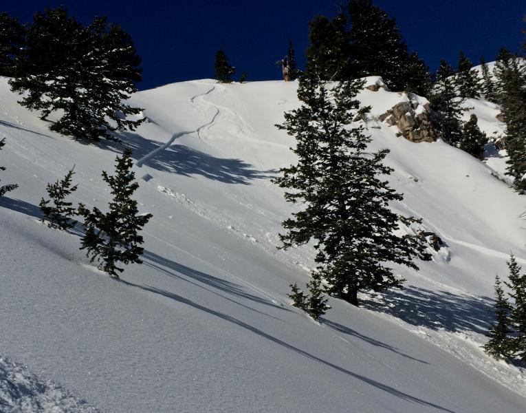
A skier triggered and then escaped this shallow wind slab avalanche in Wildcat Bowl in the Wood Camp Area on Wednesday (1-27-16). Several other similar (apparently manageable) avalanches were triggered by people locally in the past few days.
***To view our updated list of backcountry observations and avalanche activity from around Utah, go to our observations page
|
| type | aspect/elevation | characteristics |
|---|

|
|
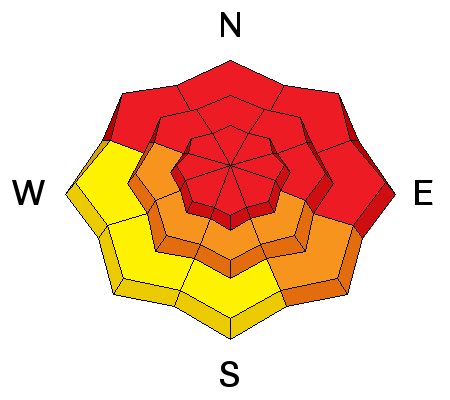
LIKELIHOOD
 LIKELY
UNLIKELY
SIZE
 LARGE
SMALL
TREND
 INCREASING DANGER
SAME
DECREASING DANGER
|
|
description
Soft storm slab avalanches including heavy new snow are likely in steep terrain today as additional new snow piles up on preexisting weak surface snow.
|
| type | aspect/elevation | characteristics |
|---|

|

|
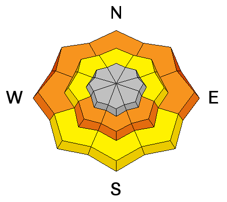
LIKELIHOOD
LIKELY
UNLIKELY
SIZE
 LARGE
SMALL
TREND
INCREASING DANGER
SAME
DECREASING DANGER
|
|
description
Heavy new snow, rain-on-snow at lower elevations, and strong winds overloaded a complex snowpack, with existing buried persistent weak layers in some areas and still weak basal layer depth hoar in others.
***Pay close attention to signs of unstable snow like recent avalanches, whumpfing, and shooting cracks, and be willing to reevaluate your plans. In these conditions you could trigger avalanches remotely, from a distance or worse, from below!
|
| type | aspect/elevation | characteristics |
|---|

|
|
LIKELIHOOD
 LIKELY
UNLIKELY
SIZE
LARGE
SMALL
TREND
 INCREASING DANGER
SAME
DECREASING DANGER
|
|
description
Cooling temperatures today will help with this problem, but rain-on-snow overnight up to around 7500' in elevation saturated the preexisting shallow snow at lower elevations, and natural wet activity is likely in some areas today. Avoid lower elevation terrain traps, and don't hang out below steep snow covered slopes like those above the Logan River Trail and my favorite mid-canyon fishing holes... Wet natural activity is most likely at low elevations in the foothills and near canyon mouths in the front canyons like lower Logan, Green, and Providence, places where you might normally take the dog for a walk or the kids sledding... |
 |
weather There is an Avalanche Warning as well as a Winter Storm Warning in effect today. These both affect all the mountains of northern Utah and Southeast Idaho. We will see continued snowfall today with an additional 4-8" of accumulation. It will be blustery with northwest winds ranging from 18-23 mph, with gusts in the 30's. As the front moves through the state, expect temperatures in the Logan area mountains to fall in the afternoon into the teens and snowfall to taper by the end of the day. It'll be mostly cloudy tonight, with a chance for lingering snow showers, moderate west-northwest wind, and a low temperature at 8500' of around 7 degrees. The next storm system moves into the state on Sunday but is expected to mostly impact central and southern Utah.
|
| general announcements The CROWBAR backcountry ski race will be Saturday January 30. More info at http://CrowbarSkiRace.org. Please submit snow and avalanche observations from your ventures in the backcountry HERE. You can call us at 801-524-5304 or email HERE, or include #utavy in your Instagram or Tweet us @UAClogan. To report avalanche activity in the Logan Area or to contact the local avalanche forecaster call me, Toby, at 435-757-7578. I'll update this advisory throughout the season on Monday, Wednesday, Friday, and Saturday mornings by about 7:30 This advisory is produced by the U.S.D.A. Forest Service, which is solely responsible for its content. It describes only general avalanche conditions and local variations always exist. |