
| During the month of April, Mark Miller will donate $75 to the charity of your choice (5 to chose from, including the Utah Avalanche Center!) Mark Miller Subaru has raised over $300k in the previous 6 Do Good Feel Good events. More Info here |  |
| During the month of April, Mark Miller will donate $75 to the charity of your choice (5 to chose from, including the Utah Avalanche Center!) Mark Miller Subaru has raised over $300k in the previous 6 Do Good Feel Good events. More Info here | |
| Advisory: Logan Area Mountains | Issued by Toby Weed for Friday - December 26, 2014 - 6:53am |
|---|


|
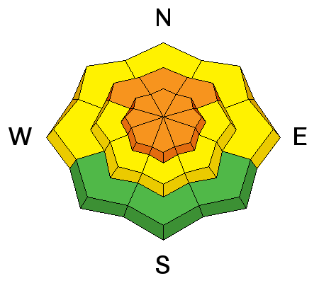
bottom line There's a CONSIDERABLE (level 3) avalanche danger, and dangerous avalanche conditions exist on drifted upper elevation slopes. Triggered wind slab and persistent slab avalanches are probable in drifted terrain steeper than about 30 degrees. In some areas, dangerous avalanches might be remote triggered from a distance, or worse, from below.
|
 |
special announcement We will offer an Avalanche Awareness Class, for beginners and as a refresher for those with some training, including a Field Day in the backcountry. Class begins on January 8 (evening) and all day Saturday January 10. Call Paige at 435-757-2794 for more information. |
 |
current conditions The Tony Grove Snotel reports 8 inches of new containing 0.7" of water in the last 24 hours. There's 64 inches of total snow at the 8400' site containing 136% of average water for the date, and its 20 degrees this morning. The UDOT Hwy 89 Logan Summit weather station is reading 9 degrees and light up canyon winds currently. Should be a very nice powder day indeed, but dangerous avalanche conditions persist on many tempting steep slopes in the backcountry. There is plenty of great untracked lower angled terrain and cold-smoke meadows to play around in today, while we let the snow stability gradually increase before hitting the steeper hills.
|
 |
recent activity
Visit our Backcountry Observations Page for more information.....
A sled triggered avalanche in the Rodeo Grounds on Tuesday, 12-23-2014
|
| type | aspect/elevation | characteristics |
|---|

|
|
LIKELIHOOD
 LIKELY
UNLIKELY
SIZE
 LARGE
SMALL
TREND
 INCREASING DANGER
SAME
DECREASING DANGER
|
|
description
Strong south winds Christmas Eve drifted significant snow in exposed terrain, creating stiff wind slabs on the lee sides of the major ridges and in and around terrain features like gullies and cliff bands. These drifts will be now hidden by a foot or so of fresh snow and softer drifts. A smaller avalanche overrunning a slope with poor snow structure could cause a larger more destructive avalanche. As usual, its best to avoid steep drifted terrain.
|
| type | aspect/elevation | characteristics |
|---|

|

|
LIKELIHOOD
LIKELY
UNLIKELY
SIZE
 LARGE
SMALL
TREND
 INCREASING DANGER
SAME
DECREASING DANGER
|
|
description
During the Solstice Storm, heavy wind-blown snow overloaded a weak layer consisting of faceted snow and surface hoar that was on the snow surface before the storm arrived. The added weight of the Christmas storm may be enough to overload slopes or bring then back into a volatile balanced state. Triggered avalanches are likely in some terrain steeper than about 30 degrees, and you might remote trigger avalanches from a distance or below. The danger will be most pronounced at upper elevations, on drifted slopes facing the northern half of the compass. Audible collapsing or whoompfing noises indicate dangerous persistent slab avalanche potential in nearby avalanche terrain.
|
 |
weather It'll be mostly cloudy and cold in the mountains today, with diminishing light northwest winds, a chance of some snow showers, and temperatures in the single digits. Wind chills will be in the negative 10 degree range, so dress accordingly. It'll be cold and cloudy tonight with temperatures around 2 degrees and sub-zero wind chills. We'll see a bit of sunshine tomorrow morning before winds shift from the southwest and clouds begin moving in in advance of the next round of Pacific storminess moves in Saturday night. We are likely to see decent accumulations in the mountains on Sunday. Check out our one-stop weather page........HERE
|
| general announcements You can now receive advisories by email for each region in the state including Logan. Go here for details. Get your advisory on your iPhone along with great navigation and rescue tools....... Utah Avalanche Center mobile app Please submit snow and avalanche observations from your ventures in the backcountry HERE. You can call us at 801-524-5304 or email HERE, or include #utavy in your Instagram or Tweet us @UAClogan. To report avalanche activity in the Logan Area or to contact the local avalanche forecaster call me, Toby, at 435-757-7578. I'll regularly update this advisory on Monday, Wednesday, Friday, and Saturday mornings by about 7:30. This advisory is produced by the U.S.D.A. Forest Service, which is solely responsible for its content. It describes only general avalanche conditions and local variations always exist. |


_1.jpg)
 copy.jpeg)