| During the month of April, Mark Miller will donate $75 to the charity of your choice (5 to chose from, including the Utah Avalanche Center!) Mark Miller Subaru has raised over $300k in the previous 6 Do Good Feel Good events. More Info here |  |
| During the month of April, Mark Miller will donate $75 to the charity of your choice (5 to chose from, including the Utah Avalanche Center!) Mark Miller Subaru has raised over $300k in the previous 6 Do Good Feel Good events. More Info here | |
| Advisory: Logan Area Mountains | Issued by Toby Weed for Saturday - December 20, 2014 - 7:24am |
|---|

|
bottom line The danger will rise to MODERATE (level 2) by this afternoon, with increasing snowfall and southwest wind. Heightened avalanche conditions are developing and you could trigger a wind slab avalanche on a drifted upper elevation slope. Heavy snowfall, strong winds, and rising temperatures will create dangerous avalanche conditions overnight.
|
 |
avalanche watch THIS AVALANCHE WATCH IS FOR THE WASATCH...BEAR RIVER, AND WESTERN UINTA MOUNTAIN RANGES AND FOR THE NORTHWESTERN PORTIONS OF THE WASATCH PLATEAU. A WARM WINTER STORM WITH HEAVY SNOW AND STRONG WINDS WILL RAPIDLY INCREASE THE AVALANCHE DANGER BEGINNING TONIGHT AND CONTINUING THROUGH MONDAY. MONITOR LATER AVALANCHE STATEMENTS FOR UPDATES ON THESE INCREASINGLY DANGEROUS AVALANCHE CONDITIONS. |
 |
current conditions There's about 4 inches of new snow at the 8400' Tony Grove Snotel from overnight, with 38 inches of total snow containing 92% of average water for the date, and it's 26 degrees. The CSI Logan Peak weather station reports light southwest winds and 20 degrees this morning. You'll still be able to find pretty good shallow powder and dust-on-crust conditions before the storm hits hard tonight, but drifting snow creates heightened avalanche conditions, and you could trigger wind slab avalanches at upper elevations today. The Tony Grove and Franklin Basin Roads are not maintained for wheeled travel in the winter.
|
 |
recent activity No avalanches were recently reported in the Logan Zone, but skiers triggered small wind slab avalanches with similar conditions yesterday in the mountains above Ogden and Park City Visit our Backcountry Observations Page for more information.....
|
| type | aspect/elevation | characteristics |
|---|

|
|
LIKELIHOOD
 LIKELY
UNLIKELY
SIZE
 LARGE
SMALL
TREND
 INCREASING DANGER
SAME
DECREASING DANGER
|
|
description
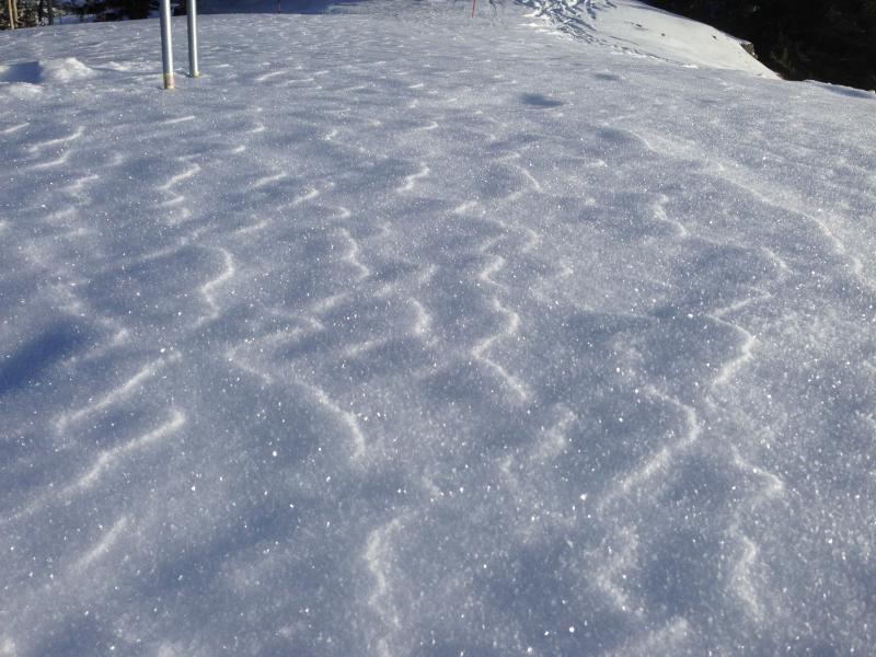
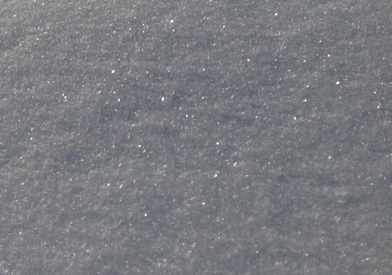
Many slopes still have a LOW danger and the stability is pretty good today. This will rapidly change tonight with the onset of heavy snowfall, rising temperatures, and very strong winds. Dangerous avalanche conditions will develop and are likely to be widespread, possibly including slopes with preexisting snow at all elevations, facing all directions. The nice shallow powder on top of the November snow is a mix of small near surface facets, surface hoar, and a bit of actual fresh powder. It's weak, and will likely be a layer that future avalanches fail on. Many avalanche paths now have stating zones that are filled in and smooth, with a hard crust capping the November snow, which could become a good bed surface. Views of glittery surface hoar or frost on the snow surface. Pretty and perhaps preserved by about an inch of fresh snow now, this could become a persistent weak layer when buried, and accumulating snow is in the forecast. (photos from 12-17-14) Cross potential avalanche paths one-at-a-time while the rest of your party watches from a safer location. Everyone needs to carry a shovel, probe, and transceiver. Be sure your rescue gear is functioning by practicing with it. You can bury your pack with your transceiver in it and have your partner find, probe, and excavate it. Then get them to do the same for you. Training your team is critical in this game. +++ Quick and Easy Avalanche Rescue Practice Video............... ***HERE
|
| type | aspect/elevation | characteristics |
|---|

|

|
LIKELIHOOD
 LIKELY
UNLIKELY
SIZE
 LARGE
SMALL
TREND
INCREASING DANGER
SAME
DECREASING DANGER
|
|
description
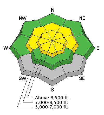
You might trigger a wind slab avalanche in upper elevation drifted terrain. Avoid drifted snow on steep slopes, and watch for wind slab development on the lee side of ridge-lines and in and around terrain features like gullies, sub-ridges, scoops, and cliff bands. Increasing west-southwest wind and snowfall this afternoon will cause a rising danger, and the danger of fresh wind slab avalanches could become more widespread.
|
 |
weather The National Weather Service in Salt Lake City has issued a Winter Storm Warning for the mountains of Northern Utah. Heavy snow is likely tonight and tomorrow, with 9 to 18 inches of accumulation of heavy, moist, and possibly inverted snow forecast by late tomorrow. West-southwest winds will increase this afternoon and become strong overnight. West winds are expected to increase further tomorrow while heavy snowfall continues and temperatures increase, causing the elevation of the rain/snow line to rise... It'll rain in the valleys. Snow showers will continue through much of Monday. Should see a bit of a break on Tuesday, but there is potential for a White Christmas in the Valley, with a strong and Cold Pacific Storm late Christmas Eve and Christmas Day. Check out our one-stop weather page........HERE
|
| general announcements You can now receive advisories by email for each region in the state including Logan. Go here for details. Get your advisory on your iPhone along with great navigation and rescue tools....... Utah Avalanche Center mobile app Please submit snow and avalanche observations from your ventures in the backcountry HERE. You can call us at 801-524-5304 or email HERE, or include #utavy in your Instagram or Tweet us @UAClogan. To report avalanche activity in the Logan Area or to contact the local avalanche forecaster call me, Toby, at 435-757-7578. I'll regularly update this advisory on Monday, Wednesday, Friday, and Saturday mornings by about 7:30. This advisory is produced by the U.S.D.A. Forest Service, which is solely responsible for its content. It describes only general avalanche conditions and local variations always exist. |


_1.jpg)