| During the month of April, Mark Miller will donate $75 to the charity of your choice (5 to chose from, including the Utah Avalanche Center!) Mark Miller Subaru has raised over $300k in the previous 6 Do Good Feel Good events. More Info here |  |
| During the month of April, Mark Miller will donate $75 to the charity of your choice (5 to chose from, including the Utah Avalanche Center!) Mark Miller Subaru has raised over $300k in the previous 6 Do Good Feel Good events. More Info here | |
| Advisory: Logan Area Mountains | Issued by Toby Weed for Tuesday - April 8, 2014 - 7:07am |
|---|


|
bottom line Heightened avalanche conditions exist and there's a MODERATE or level 2 danger in the Backcountry. Triggered wind slab avalanches and cornice falls are possible on drifted upper elevation slopes. Sun and warming may create dangerous conditions, and the danger of wet or heat related avalanches will probably rise to CONSIDERABLE or level 3 this afternoon in some steep terrain. Evaluate the snow and terrain carefully.
|
 |
current conditions The snow will get sloppy earlier today after a poor overnight re-freeze, and we're expecting a very warm and sunny day in the mountains. The Tony Grove Snotel at 8400' reports 34 degrees and there's 109 inches of total snow, with 136% of average water content for the date. It's 30 degrees at the 9700' CSI Logan Peak weather station, and I'm currently reading west-northwest winds averaging in the mid teens.
|
 |
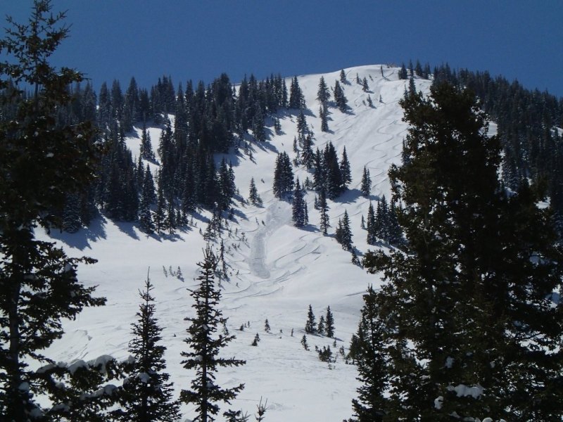
recent activity Several people triggered shallow wind slabs yesterday in the Central Wasatch Range backcountry, with one person able to self arrest after being caught. Locally: A snowboarder unintentionally triggered and was able to ride off of a shallow wind slab on the north face of Millville Peak yesterday. Also, observers reported natural wet avalanche activity in lower Providence Canyon and in the Wellsvilles from over the weekend. Visit our Backcountry Observations Page for details on the season's activity.
A shallow triggered soft slab on Millville Peak, 4-7-2014. Flygare
|
| type | aspect/elevation | characteristics |
|---|

|

|
LIKELIHOOD
 LIKELY
UNLIKELY
SIZE
 LARGE
SMALL
TREND
 INCREASING DANGER
SAME
DECREASING DANGER
|
description
|
| type | aspect/elevation | characteristics |
|---|

|

|
LIKELIHOOD
 LIKELY
UNLIKELY
SIZE
LARGE
SMALL
TREND
INCREASING DANGER
SAME
DECREASING DANGER
|
|
description
Direct sun and warming will cause a heightened avalanche danger on steep slopes today, and dangerous wet or heat related conditions may well develop. Avoid and stay out from under steep slopes with saturated snow.
|
 |
weather It'll be sunny and almost hot in the mountains today, with 9000' high temperatures forecast to reach 52 degrees. Expect overnight low temperatures, well above freezing tonight, around 38 degrees. It'll be mostly sunny tomorrow, but with a few clouds and maybe more of a southwest breeze and a high of 54 degrees expected. Warm weather will continue through the week, with a few snow showers possible on Wednesday. Check out our one-stop weather page........HERE |
| general announcements Utah Avalanche Center mobile app - Get your advisory on your iPhone along with great navigation and rescue tools. Remember your information can save lives. If you see anything we should know about, please participate in the creation of our own community avalanche advisory by submitting snow and avalanche conditions. You can also call us at 801-524-5304 or 800-662-4140, email by clicking HERE, or include #utavy in your tweet or Instagram. Follow us at UAClogan on Twitter I'll issue weekend and intermittent advisories through April. This advisory is produced by the U.S.D.A. Forest Service, which is solely responsible for its content. It describes only general avalanche conditions and local variations always exist. |


_1.jpg)