25th Annual Black Diamond Fall Fundraising Party
Thursday, September 13; 6:00-10:00 PM; Black Diamond Parking Lot
25th Annual Black Diamond Fall Fundraising Party
Thursday, September 13; 6:00-10:00 PM; Black Diamond Parking Lot
| Advisory: Uintas Area Mountains | Issued by Craig Gordon for Tuesday - March 6, 2018 - 3:08am |
|---|

|
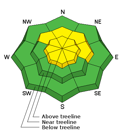
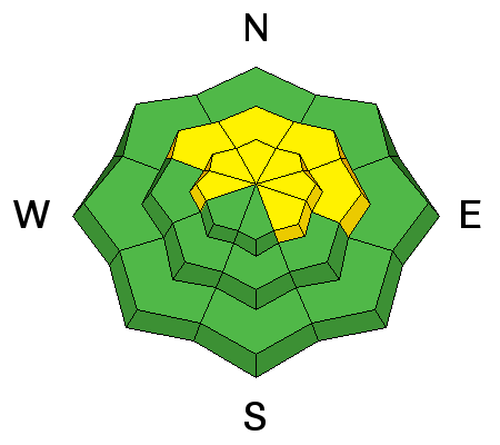
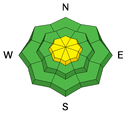
bottom line In upper elevation terrain, especially in the wind zone at and above treeline, the avalanche danger is MODERATE. Human triggered avalanches are POSSIBLE on steep wind drifted slopes facing the north half of the compass, particularly those with an easterly component to their aspect. An avalanche triggered today can quickly get out of hand if it breaks into weak layers of snow, now buried deeper in our snowpack. LOW avalanche danger exists on mid and lower elevation, wind sheltered terrain and on most slopes facing the south half of the compass.
|
 |
current conditions While not the blockbuster we hoped for, the weekend storm none-the-less delivered about a foot of snow across the range. This morning, skies are clear and temperatures near zero. Along the high ridges west and northwest winds are blowing in the teens and low 20's. Riding and turning conditions are quite good, particularly on mid elevation, wind sheltered slopes.
Above are 24 hour temperatures and snow depth from Trial Lake along with winds and temperatures from Windy Peak. More remote Uinta weather stations are found here
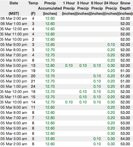
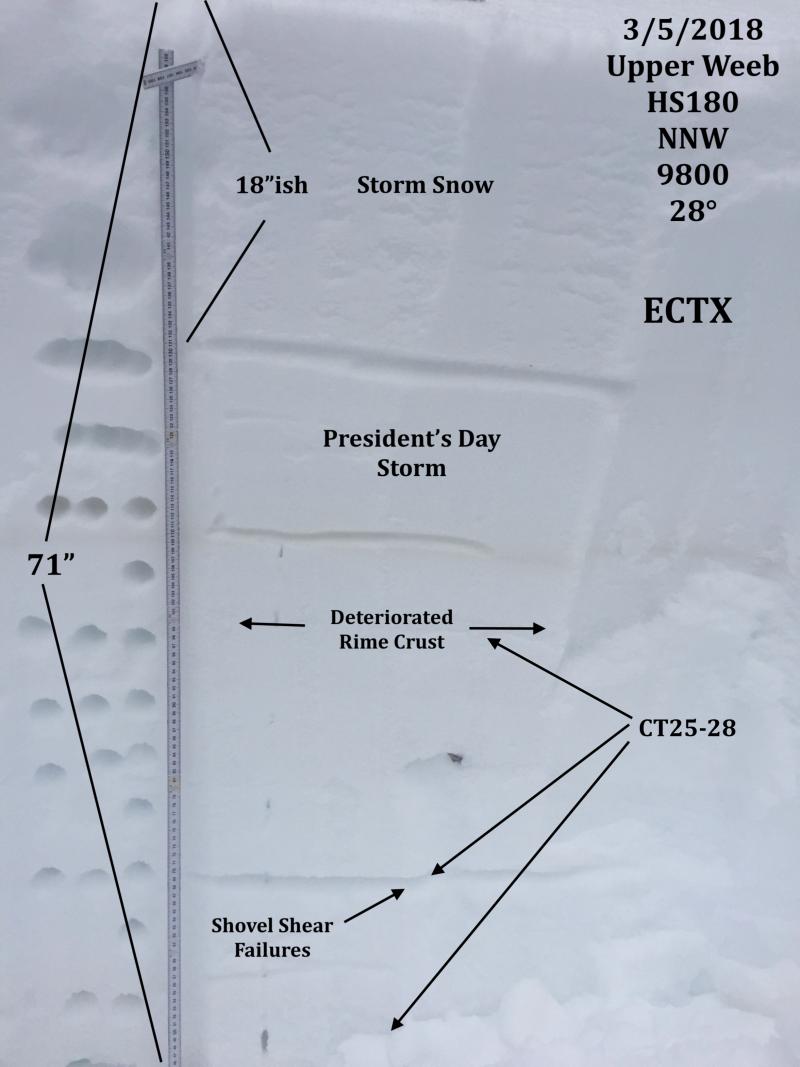
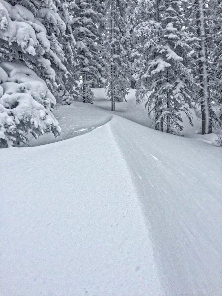
JG was in Weber Canyon yesterday and found mostly stable snow and excellent riding conditions. His beautifully detailed pit in the image above clearly illustrates the snowpack in this area. More on his travels found here. You can find a great body of recent trip reports, observations, and snow data here.
|
 |
recent activity
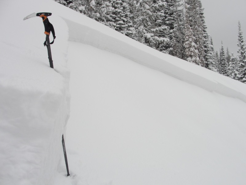
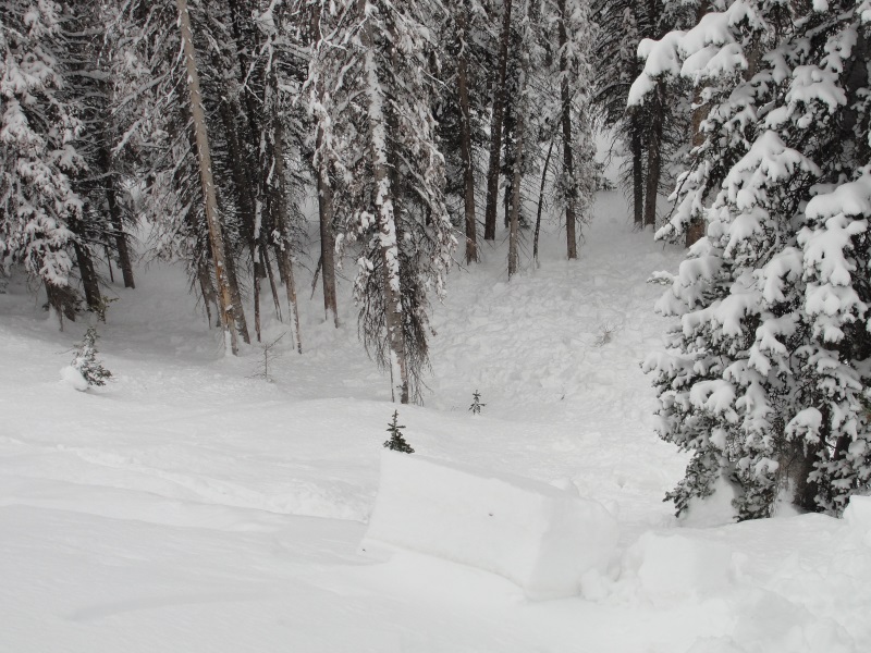
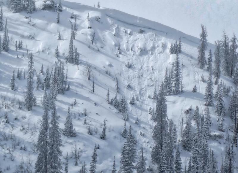
No significant new avalanche activity on Monday, but Micheal J was in Weber Canyon Sunday and triggered this 2' deep x 50' wide slab on a steep, northerly slope. Of note... this slide was triggered from a distance, while Micheal was skinning up an adjacent slope. It fits the recent trend of pockety avalanches that are failing near the late January rime crust. Not widespread, but worth banking in the cerebral hard drive, especially if you're getting into steep, committing terrain or slopes that runout into a group of baseball bats like in the image above. |
| type | aspect/elevation | characteristics |
|---|

|
|
LIKELIHOOD
 LIKELY
UNLIKELY
SIZE
 LARGE
SMALL
TREND
 INCREASING DANGER
SAME
DECREASING DANGER
|
|
description
It feels like the snowpack is adjusting to the recent storm and in most terrain across the range the pack is happy in its own skin. However, the Uinta's are a big zone and I bet there's still a surprise or two lurking out there today. Prime suspects include terrain that has already avalanched this year along with a vast majority of steep, shady slopes that have remained thin and shallow this winter. Terrain with these characteristics remains suspect and should be considered guilty until proven otherwise. Sounds complicated, but the answer is easy. The way we manage unpredictable avalanche dragons is to simply avoid where they live. And now that south facing terrain has a snowpack, that's your exit strategy. Simply switch aspect, let the shady slopes settle and gain some strength and ride in the sun
I'm continuing to avoid steep, rocky terrain and slopes that already avalanched close to the ground this year, similar to the image above. |
| type | aspect/elevation | characteristics |
|---|

|
|
LIKELIHOOD
LIKELY
UNLIKELY
SIZE
 LARGE
SMALL
TREND
 INCREASING DANGER
SAME
DECREASING DANGER
|
|
description
Prior to the storm, winds were all over the place, forming stiff wind slabs on the leeward side of upper elevation ridges and around terrain features like chutes and gullies. Today's hard slabs are gonna be a bit stubborn, but once triggered, they'll break deeper and wider than you might expect and are gonna pack a punch.
You can ride safely today by looking for and avoiding fat, rounded pillows of snow, especially if they sound hollow like a drum. |
 |
weather
High pressure builds over the region the next few days. Look for mostly sunny skies, temperatures warming into the 30's and northwest winds remaining light, blowing in the teens and 20's. |
| general announcements The information in this advisory expires 24 hours after the date and time posted, but will be updated by 7:00 AM Wednesday March 7th, 2018. If you're getting out and about, please let me know what you're seeing especially if you see or trigger and avalanche. I can be reached at [email protected] or 801-231-2170 It's also a good time to set up one of our very popular avalanche awareness classes. Reach out to me and I'll make it happen. This information does not apply to developed ski areas or highways where avalanche control is normally done. This advisory is from the U.S.D.A. Forest Service, which is solely responsible for its content. This advisory describes general avalanche conditions and local variations always occur. |