25th Annual Black Diamond Fall Fundraising Party
Thursday, September 13; 6:00-10:00 PM; Black Diamond Parking Lot
25th Annual Black Diamond Fall Fundraising Party
Thursday, September 13; 6:00-10:00 PM; Black Diamond Parking Lot
| Advisory: Uintas Area Mountains | Issued by Craig Gordon for Saturday - February 24, 2018 - 2:48am |
|---|

|
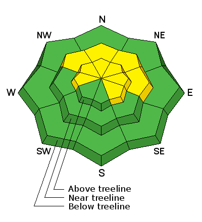
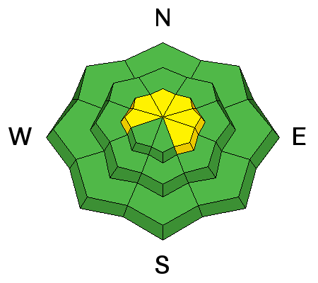
bottom line Heads up- the avalanche danger might be slightly more pronounced from about Trial Lake to Strawberry. In mid and upper elevation terrain, especially in the wind zone at and above treeline, the avalanche danger is MODERATE. Human triggered avalanches are possible on steep wind drifted slopes, facing the north half of the compass, particularly those with an easterly component to their aspect. An avalanche triggered today can quickly get out of hand if it breaks into weak layers of snow, now buried deeper in our snowpack. Lose some elevation or switch aspect and you'll find LOW avalanche danger on lower elevation wind sheltered terrain and on most slopes facing the south half of the compass.
|
 |
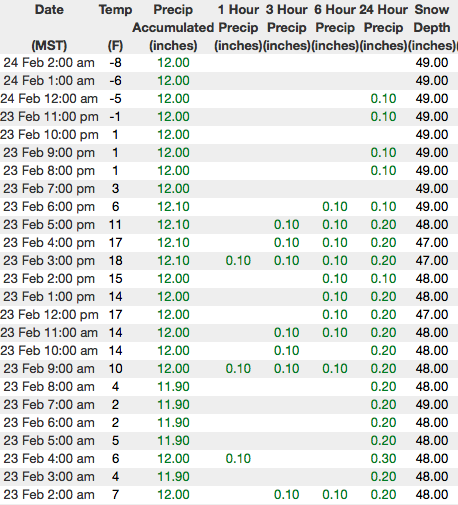
current conditions Yesterday's little storm delivered an evenly distributed 3" of light density snow across the range. Since Sunday close to 2' of snow has fallen. Skies cleared last night and temperatures cratered into negative territory, currently hovering right around -10 degrees at most locations. West and southwest winds are blowing in the 20's and 30's along the high ridges, and yes... it's a little crisp in upper elevation terrain with wind chill values registering near -30 degrees. Riding and turning conditions are the best they've been all year. Above are 24 hour temperatures and snow depth from upper Trial Lake along with winds and temperatures from Windy Peak. More remote Uinta weather stations are found here You can find a great body of recent trip reports, observations, and snow data here.
|
 |
recent activity
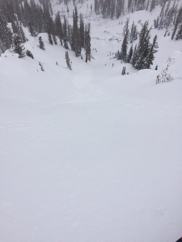
Chris Brown was stomping around Chalk Creek yesterday and triggered this fresh slab on a steep, wind loaded slope which broke into some weaker snow as it crashed on the slope below. More on his travels are found here.
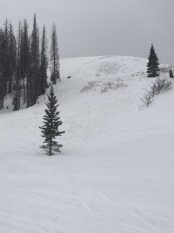
And Tyler St. Jeor was near Currant Creek Peak on Thursday and found this recently triggered slide on a steep, wind loaded slope near Tower Mountain. More on his travels here. |
| type | aspect/elevation | characteristics |
|---|

|

|
LIKELIHOOD
 LIKELY
UNLIKELY
SIZE
 LARGE
SMALL
TREND
 INCREASING DANGER
SAME
DECREASING DANGER
|
|
description
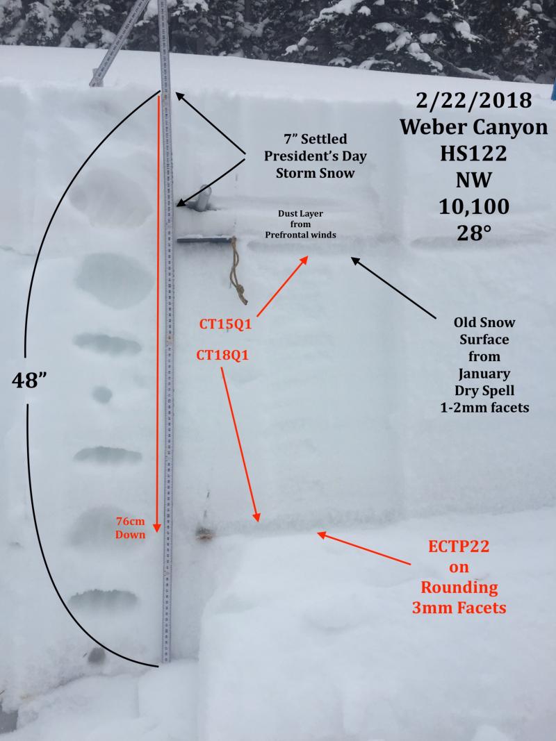
JG's beautiful pit profile clearly illustrates where the pack is deep, it's comfortable in its own skin and can take a good thump. His take was... "Feeling like the snowpack is gaining strength but the persistent slab issue in your face doesn't inspire confidence to jump into steeper terrain." Sage advice fo sho.
However, where the pack is shallow, (like this older slide pictured above near Currant Creek that Tyler found yesterday) the jury is still out. Suspect areas include terrain that has already avalanched this year along with a vast majority of steep, shady slopes on the south half of the range... from about Trial Lake through Strawberry. As always in this case, the best offense is a good defense. Simply avoid steep, rocky, wind drifted slopes, especially if they've got a "trapdoor" or punchy feeling. |
| type | aspect/elevation | characteristics |
|---|

|
|
LIKELIHOOD
 LIKELY
UNLIKELY
SIZE
 LARGE
SMALL
TREND
 INCREASING DANGER
SAME
DECREASING DANGER
|
|
description
Today's drifts will be manageable in size and depth, but you could none-the-less get surprised on steep leeward slopes or near the entrances of steep chutes where even a small wind drift could take you for an unexpected ride. While not widespread, it's not completely straight-forward and today you'll want to gather as much information as possible. Be on the lookout for clues to unstable snow such as shooting cracks and tweak small test slopes like road banks and see how they're reacting before getting into steep, commiting terrain. |
 |
weather
A short-lived break in the action is scheduled for this morning and we should see partly cloudy skies and temperatures warming into the mid teens. Westerly winds increase as the day wares on and blow in the upper 30's by days end. Clouds increase and snow develops with 3"-6" expected by late Sunday morning. Another storm is on tap for Sunday night and Monday. |
| general announcements The information in this advisory expires 24 hours after the date and time posted, but will be updated by 7:00 AM Sunday February 25th, 2018. If you're getting out and about, please let me know what you're seeing especially if you see or trigger and avalanche. I can be reached at [email protected] or 801-231-2170 It's also a good time to set up one of our very popular avalanche awareness classes. Reach out to me and I'll make it happen. This information does not apply to developed ski areas or highways where avalanche control is normally done. This advisory is from the U.S.D.A. Forest Service, which is solely responsible for its content. This advisory describes general avalanche conditions and local variations always occur. |