25th Annual Black Diamond Fall Fundraising Party
Thursday, September 13; 6:00-10:00 PM; Black Diamond Parking Lot
25th Annual Black Diamond Fall Fundraising Party
Thursday, September 13; 6:00-10:00 PM; Black Diamond Parking Lot
| Advisory: Uintas Area Mountains | Issued by Craig Gordon for Wednesday - March 22, 2017 - 3:39am |
|---|

|
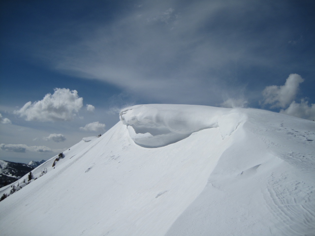
bottom line The avalanche danger is generally LOW this morning. If the sun pokes out, the danger rises to MODERATE and human triggered avalanches are POSSIBLE. When the snow surface heats up, you'll want to get off of and out from under on all steep, sun-exposed slopes. Once triggered, today's wet slides may fan out, entraining more snow than you might expect.
|
 |
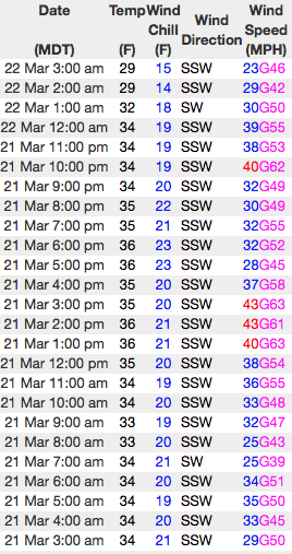
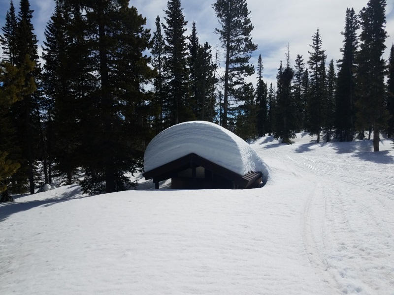
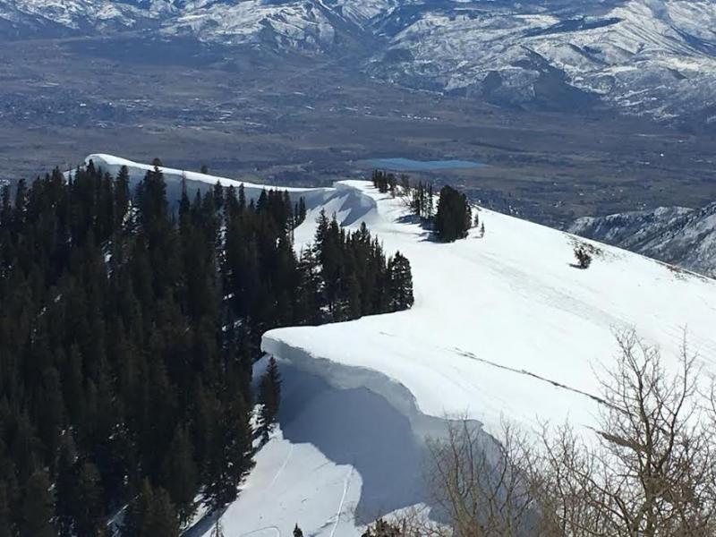
current conditions Under a blanket of clouds, temperatures are in the low to mid 30's, though a few hot spots (like Strawberry Divide... below) report overnight lows in the 40's. Southwest winds have ramped up somewhat and are blowing 25-45 mph along the high ridges. Riding and turning conditions are slightly underwhelming and our snowpack has taken a bit of a hit. In the past week we've lost about a foot of snow depth. Cloud cover, warm overnight temperatures, and wind will most likely inhibit today's corn harvest. But wait... there's more! There's a change in the pattern slated for later today through the weekend and winter returns from its hiatus. In the meantime, it's probably a good day to take off and get your taxes done :)
Real time wind, snow, and temperatures for the Uinta's are found here
North facing terrain is holding steady, but even with a deep snowpack, some of our sunny slopes are starting to shed their winter coats. Snowpack observations and trip reports are found here. |
 |
recent activity No significant avalanche activity to report from yesterday. A full list of Uinta avalanche activity is found here. |
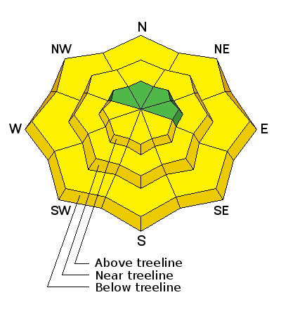
| type | aspect/elevation | characteristics |
|---|

|
|
LIKELIHOOD
 LIKELY
UNLIKELY
SIZE
 LARGE
SMALL
TREND
 INCREASING DANGER
SAME
DECREASING DANGER
|
|
description
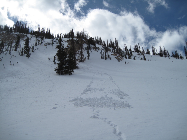
Not much has changed this week and the snowpack seems happy in its own skin. Today's wet avalanche activity largely depends on the balance of sun, cloud cover, and wind. As the snow turns damp, manky, or unsupportable you'll need to get off of and out from under steep, sunny slopes and avoid terrain traps like gullies and road cuts where tree snapping, cement-like debris can stack up very deeply. Remember- this is the time of year when you wanna think about your end of the day exit strategy.
Ted was near Moffit Peak yesterday and other than this shallow damp slide, found stable snow, yet hit or miss riding conditions. More on his travels here. |
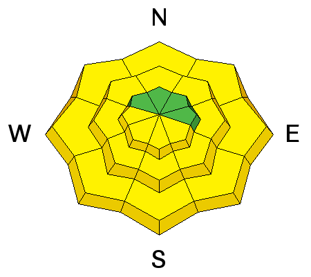
| type | aspect/elevation | characteristics |
|---|

|
|
LIKELIHOOD
LIKELY
UNLIKELY
SIZE
 LARGE
SMALL
TREND
 INCREASING DANGER
SAME
DECREASING DANGER
|
|
description
|
 |
weather A storm system slides through the region today and tomorrow. Ahead of the storm, expect warm temperatures with highs in the 40's and southwest winds gusting to 60 mph along the high ridges. Snow showers and thunderstorms develop and become more widespread this afternoon and evening. The core of the storm arrives tonight and tomorrow, with cooling temperatures and falling snow levels. A foot of snow by late Thursday still looks like a good bet. A break in the action for Friday, with the next cool and moist storm system arriving late Saturday.
|
| general announcements Remember your information can save lives. If you see anything we should know about, please participate in the creation of our own community avalanche advisory by submitting snow and avalanche conditions. You can call me directly at 801-231-2170, email [email protected] The information in this advisory is from the US Forest Service which is solely responsible for its content. This advisory describes general avalanche conditions and local variations always occur. The information in this advisory expires 24 hours after the date and time posted, but will be updated by 7:00 AM on Thursday March 23rd. |