25th Annual Black Diamond Fall Fundraising Party
Thursday, September 13; 6:00-10:00 PM; Black Diamond Parking Lot
25th Annual Black Diamond Fall Fundraising Party
Thursday, September 13; 6:00-10:00 PM; Black Diamond Parking Lot
| Advisory: Uintas Area Mountains | Issued by Craig Gordon for Saturday - January 14, 2017 - 4:01am |
|---|


|
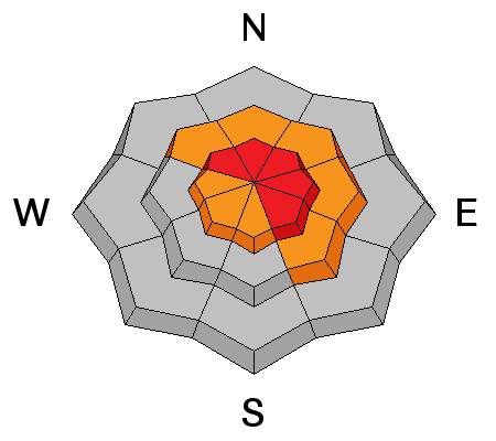
bottom line Once triggered, today's avalanches will break deep and wide, resulting in a large, dangerous, and most likely unsurvivable avalanche. In the wind zone, at and above treeline, the avalanche danger is HIGH today. Very dangerous, human triggered avalanches are LIKELY on steep, wind drifted slopes, especially those facing the north half of the compass, and particularly those with an easterly component to their aspect. You'll find a CONSIDERABLE avalanche danger on steep wind drifted slopes at mid elevations and human triggered avalanches are PROBABLE. Avalanche hazard is more predictable at lower elevations where you'll encounter a MODERATE avalanche danger. Don't let your guard down... human triggered avalanches are possible on steep, wind drifted, shady slopes, facing the north half of the compass. Big open meadows with no steep slopes above or adjacent to where you're traveling are today's exit strategy for safe riding.
|
 |
special announcement Our preliminary accident report from the close call in Uinta's is posted and can be found here. Also... in a show of Herculean strength, Trace Carrillo installed the Beacon Basin training park at Nobletts Trailhead yesterday. I encourage everyone to stop by, practice with your avalanche rescue gear, and if you bump into Trace give him a big high-five... yo :) |
 |
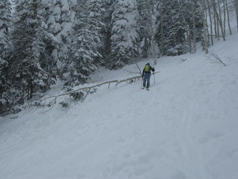
current conditions Skies finally cleared late last night and revealed a big, bright, beautiful moon. Temperatures are in the teens and low 20's and winds are about as light as they get for our region, blowing less than 15 mph even along the high ridges. The surface snow is light and surfy and it doesn't have to be steep to be fun. Five star riding and turning conditions are found on low angle, mid and low elevation slopes, where the snow is deep and avalanche danger predictable. Real time wind, snow, and temperatures for the Uinta's are found here Snowpack observations and trip reports are found here. |
 |
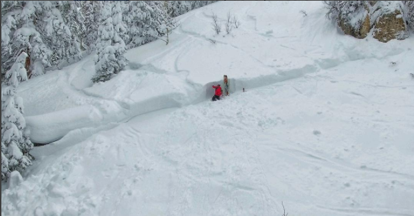
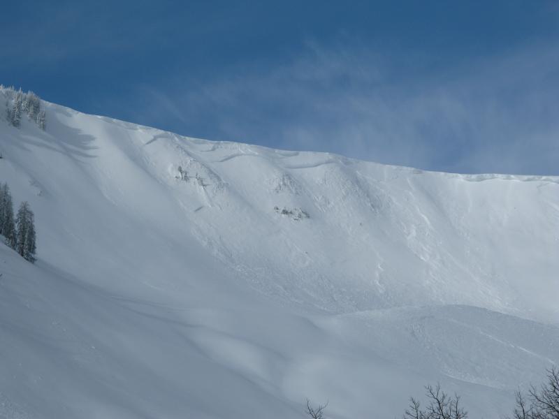
recent activity This is the type of avalanche we're dealing with in the Uintas. Once triggered, avalanches are breaking deep and wide... snapping trees along the way. They're definitely something you don't want to be on the receiving end of!
Images above are at the scene of Wednesday's avalanche accident involving two hybrid snowboarders, who utilized motorized ascent to gain access to this terrain in Smith-Moorehouse. Trent and I investigated the slide and the report is found here. What we do know is two snowboarders are very lucky to be alive after triggering this 4' deep x 300' wide avalanche which broke to weak faceted snow formed in late December. A full list of recent Uinta avalanche activity is found here. |
| type | aspect/elevation | characteristics |
|---|

|
|
LIKELIHOOD
 LIKELY
UNLIKELY
SIZE
 LARGE
SMALL
TREND
 INCREASING DANGER
SAME
DECREASING DANGER
|
|
description
These are the kind of snowpack conditions that trick most all-mountain riders. You're best bet for the next few days is to simply avoid steep, wind drifted terrain, especially mid and upper elevation slopes facing the north half of the compass. Since the beginning of the New Year we've nearly doubled our snowpack and added over 7" of water weight... unprecedented for our hood. Until this week, avalanche conditions have been pretty straight-forward, but I think Tuesday nights storm sent the region into a tailspin and the western Uinta's experienced a remarkable, tree snapping, natural avalanche cycle. The carnage is jaw dropping with many slopes reaching their historic potential. The goods news is, many slopes avalanched naturally. The bad news is, there's plenty of slopes that wait for a trigger like us to come along and knock the legs out from underneath. But wait... there's more. The bad news within the bad news is, the problem is complicated because the snow will feel strong and bomber under our skis, board, or sled. The snow will lure us well out onto the slope before it collapses and we're staring down the barrel of a very dangerous avalanche. So here's the deal... we've gotta think not only about the snow we're riding in, but also the snow we're riding on and there's a few buried weak layers that are straining to adjust to all this added weight. The snowpack is trending towards more stable conditions, but right now we need to tone it down, think about the consequences of triggering a slide, and be patient for a few more days.
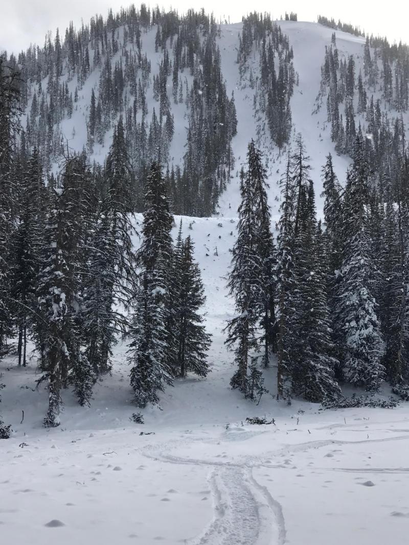
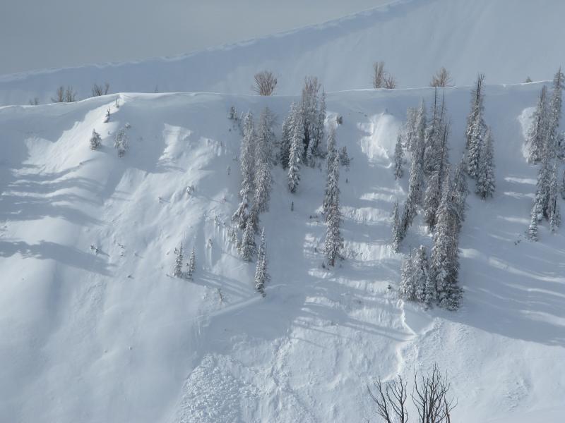
An avalanche peeling off the North facing Moffit Chutes was packing heat when it blasted over this bench, splashing mature timber onto the uphill slope across canyon. (St. Jeor photo)
|
| type | aspect/elevation | characteristics |
|---|

|
|
LIKELIHOOD
 LIKELY
UNLIKELY
SIZE
 LARGE
SMALL
TREND
 INCREASING DANGER
SAME
DECREASING DANGER
|
|
description
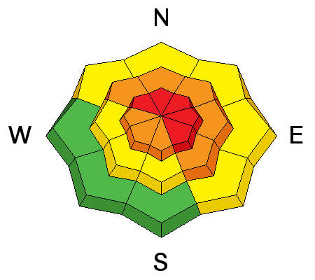
A few drifts along the leeward side of upper elevation ridges and around mid elevation terrain features like chutes and gullies might still be sensitive to our additional weight. Remember- once triggered a seemingly manageable slide can turn your world upside down if it breaks into weaker layers buried deep in our pack. Best bet is to simply avoid steep, wind drifted terrain for the next couple of days. |
 |
weather A beautiful weekend is on tap with light winds, sunny skies, and temperatures warming into the 30's. Pretty quiet until the end of the week when the pattern shifts gears back to storm mode. |
| general announcements Remember your information can save lives. If you see anything we should know about, please participate in the creation of our own community avalanche advisory by submitting snow and avalanche conditions. You can call me directly at 801-231-2170, email [email protected] The information in this advisory is from the US Forest Service which is solely responsible for its content. This advisory describes general avalanche conditions and local variations always occur. The information in this advisory expires 24 hours after the date and time posted, but will be updated by 7:00 AM on Sunday January 15th. |