25th Annual Black Diamond Fall Fundraising Party
Thursday, September 13; 6:00-10:00 PM; Black Diamond Parking Lot
25th Annual Black Diamond Fall Fundraising Party
Thursday, September 13; 6:00-10:00 PM; Black Diamond Parking Lot
| Advisory: Uintas Area Mountains | Issued by Craig Gordon for Thursday - December 22, 2016 - 3:42am |
|---|

|
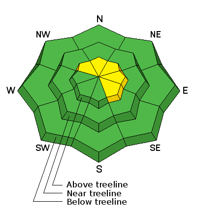
bottom line In the wind zone at upper elevations, the avalanche danger is MODERATE today. Human triggered avalanches are POSSIBLE, especially on steep, wind drifted slopes facing the north half of the compass. Once triggered, today's avalanches have the potential to break deeper and wider than you might expect. Mid and low elevation wind sheltered terrain offers generally LOW avalanche danger
|
 |
special announcement
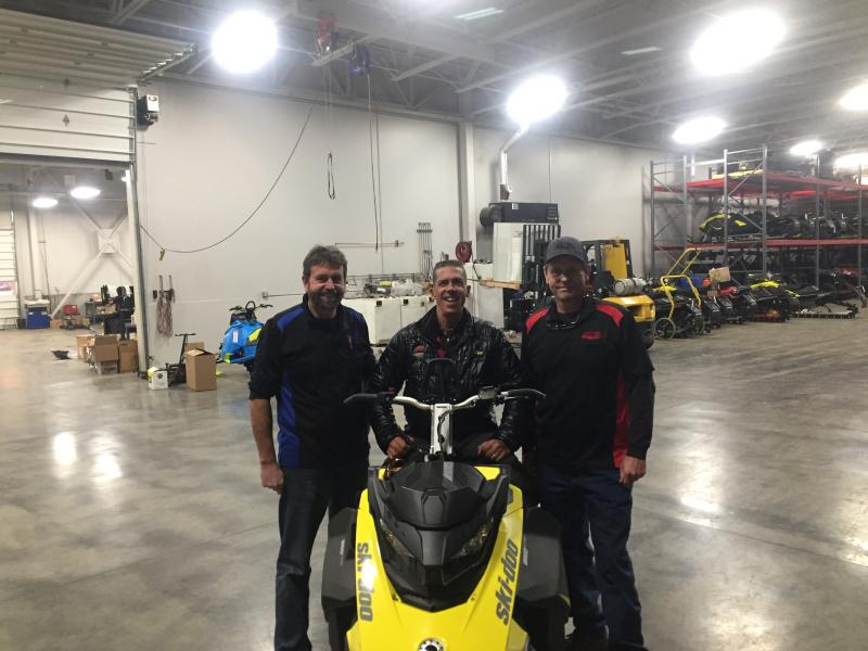
Huge thanks to Weller's Recreation for generously coordinating our great loaner program with BRP/Ski-Doo and helping to provide a new sled to use for the 2016-17 season. We're super grateful to have such amazing partners helping us keep riders on top of the greatest snow on earth.
Bonus... stepping out of Weller's shop in Kamas after picking up our new sled I got to experience this spectacular sunset. |
 |
current conditions Skies are partly cloudy and temperatures in the teens and low 20's. Winds are light and variable, blowing just 10-15 mph, even along the high peaks. Yesterday's weak, little cold front delivered an inch or two of snow and this morning you'll find cold, creamy snow on a mostly supportable base. Riding and turning conditions are about as good as they get. Real time wind, snow, and temperatures for the Uinta's are found here. Recent observations are found here.
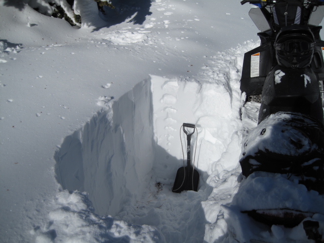
Ted was in Gold Hill Tuesday and found a nice, deep snowpack and mostly stable conditions. More on his travels here. |
 |
recent activity
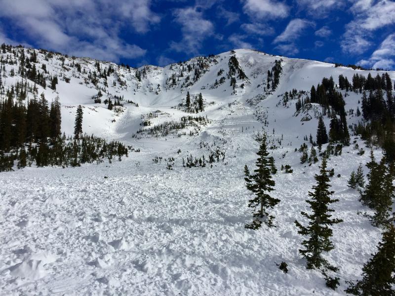
Looks like a Uinta avalanche doesn't it? Meanwhile in the Wasatch... two extremely lucky riders came out on top after a very close call in Little Cottonwood Canyon late Monday. (M. Staples photo) More details found here. A full list of recent Uinta avalanche activity is found here. |
| type | aspect/elevation | characteristics |
|---|

|
|
LIKELIHOOD
 LIKELY
UNLIKELY
SIZE
 LARGE
SMALL
TREND
 INCREASING DANGER
SAME
DECREASING DANGER
|
|
description
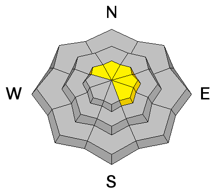
No reports of the weird in this department, but I bet there's a pocket or two still lurking out there that just needs a little coaxing. Once it fails... all bets are off. Found mostly on steep, rocky, upper elevation slopes facing the north half of the compass, todays slabs may be harder to initiate, but once triggered, have the potential to break into weak layers now buried deep in our snowpack. |
| type | aspect/elevation | characteristics |
|---|

|

|
LIKELIHOOD
 LIKELY
UNLIKELY
SIZE
 LARGE
SMALL
TREND
INCREASING DANGER
SAME
DECREASING DANGER
|
|
description
Wind drifts along the leeward side of upper elevation ridges and around terrain features like chutes, gullies, and sub-ridges are today's second avalanche issue. While predictably breaking at or below your skis, board, or sled even a shallow slab can get quickly out of hand if it breaks into deeper buried weak layers as it crashes down on the slope below. I'd look for and avoid any fat, rounded piece of snow, especially if it feels or sounds hollow like a drum. |
 |
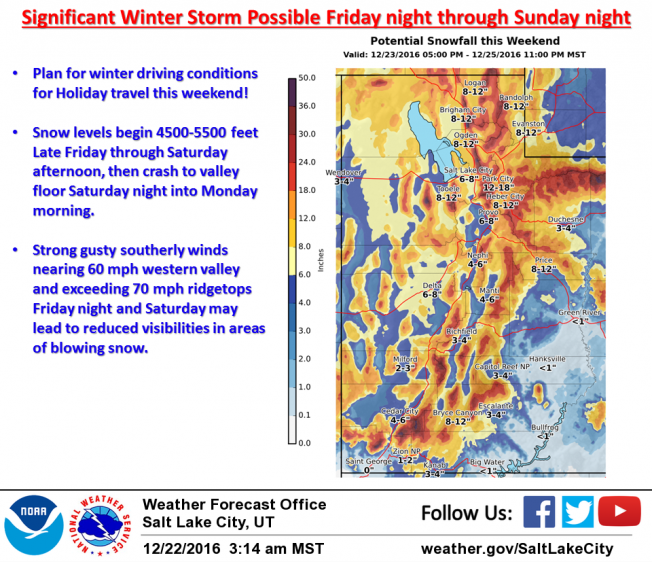
weather Today we can expect partly cloudy skies, temperatures rising into the low 30's, and southwest winds blowing in the 20's along the high ridges. Overnight lows under clearing skies dip into the teens. Increasing clouds Friday afternoon with a good shot of snow along with strong ridgetop winds developing late in the day. Looks like a good Christmas storm on tap with a foot or two of snow by late Sunday. More details on strength and timing for tomorrow's update.
|
| general announcements Remember your information can save lives. If you see anything we should know about, please participate in the creation of our own community avalanche advisory by submitting snow and avalanche conditions. You can call me directly at 801-231-2170, email [email protected] The information in this advisory is from the US Forest Service which is solely responsible for its content. This advisory describes general avalanche conditions and local variations always occur. The information in this advisory expires 24 hours after the date and time posted, but will be updated by 7:00 AM on Friday December 23rd. |