25th Annual Black Diamond Fall Fundraising Party
Thursday, September 13; 6:00-10:00 PM; Black Diamond Parking Lot
25th Annual Black Diamond Fall Fundraising Party
Thursday, September 13; 6:00-10:00 PM; Black Diamond Parking Lot
| Advisory: Uintas Area Mountains | Issued by Craig Gordon for Monday - November 21, 2016 - 3:56am |
|---|
 |
special announcement Until the season really gets rolling, I'll update this information as storms start to develop or if conditions change rapidly. The next advisory update will be Tuesday, November 22nd. In the meantime, while you're waiting for snow to stack up, please let us know what you're seeing. You can reach me at [email protected] Also, before life gets crazy busy, consider scheduling one of our free avalanche awareness presentations (contact me at [email protected]) or sign up for our ever-popular, sled specific Avy Awareness and Riding Skills Workshop. (Click here for more details) Whole foods event: Between now and Jan 15th: Donate to the Utah Avalanche Center by shopping at Whole Foods Market Utah! when you visit Whole Foods Market Trolley Square, Sugarhouse & Cottonwood Heights locations and bring in your re-usable bags, Whole Foods will donate a dime per bag to Utah Avalanche Center when the cashier asks if you want to “keep or donate” your bag credit and you say “DONATE". |
 |
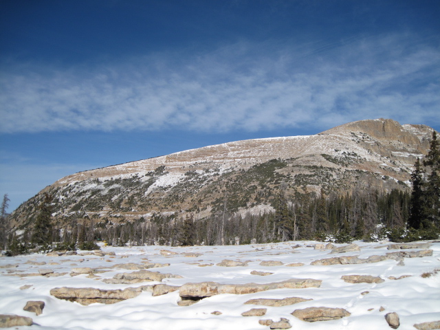
current conditions Clouds thickened late yesterday and we were able to squeeze out a couple inches of new snow overnight. Temperatures are mild and in the low to mid 30's. Along the high peaks southwest winds have mellowed somewhat and are currently blowing in the 20's and 30's. It's not quite winter yet and in general, there's only about 6"-10" of snow on the ground. Ted was out and about Saturday and submitted his trip report along with a nice video overview of current conditions... found here. Real time wind, snow, and temperatures for the Uinta's are found here.
Not much snow, even on the high elevation slopes near Bald Mountain Pass. Ted Scroggin photo. |
 |
recent activity No new avalanche activity to report |
| type | aspect/elevation | characteristics |
|---|


|
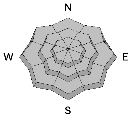
|
LIKELIHOOD
 LIKELY
UNLIKELY
SIZE
 LARGE
SMALL
TREND
 INCREASING DANGER
SAME
DECREASING DANGER
|
|
description
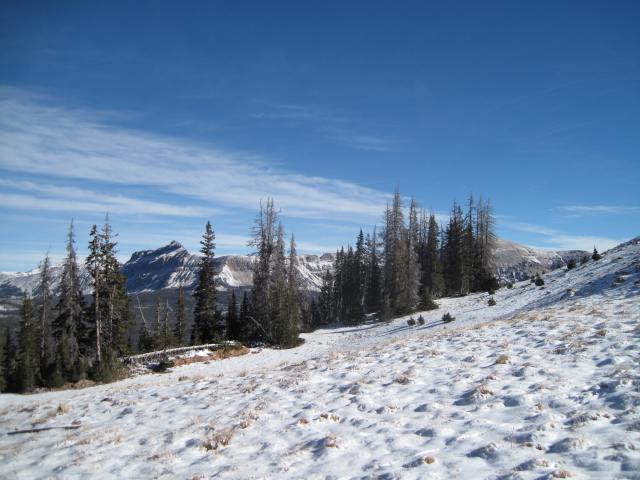
Since last Thursday the Uinta's have picked up roughly 8" of medium density snow, though there's hardly enough new snow to recreate on. But the good news is... all this new snow fell on relatively dry, warm ground. What that means from an avalanche and snow stability perspective is that we're off to a benign start and there's very little, weak, sugary snow on the ground to contend with. Of course, that can all change and we'll keep you updated as the early season starts to unfold, but right now we're off to a good start.
Shallow snowpack, but not much weak sugary snow near the ground. Ted Scroggin photo. |
 |
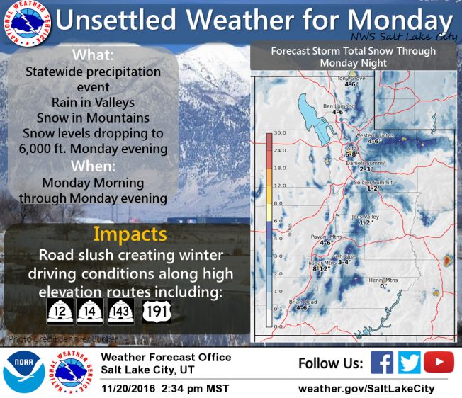
weather Warm and moist ahead of a cold front slated to slide across our area later today. Until then we can expect temperatures in the mid 30's, southwest winds in the upper 30's and 40's, and a couple inches of snow throughout the day. Temperatures drop late in the day, winds switch to the northwest, and 4"-8" of snow should stack up overnight with lingering snow showers Tuesday morning. Another quick hitter is on tap for late Wednesday and Thursday giving us an additional 3"-6" of snow.
|
| general announcements Remember your information can save lives. If you see anything we should know about, please participate in the creation of our own community avalanche advisory by submitting snow and avalanche conditions. You can call me directly at 801-231-2170, email [email protected] The information in this advisory is from the US Forest Service which is solely responsible for its content. This advisory describes general avalanche conditions and local variations always occur. The information in this advisory expires 24 hours after the date and time posted, but will be updated on Tuesday November 22nd with general avalanche information. |