| Please join us at the 23rd annual Black Diamond Fall Fundraiser Party Thursday Sept 15. Tickets are on sale now here, at the Black Diamond store & at REI. Special bonus raffle for online ticket purchasers! |
| Please join us at the 23rd annual Black Diamond Fall Fundraiser Party Thursday Sept 15. Tickets are on sale now here, at the Black Diamond store & at REI. Special bonus raffle for online ticket purchasers! |
| Advisory: Uintas Area Mountains | Issued by Craig Gordon for Friday - April 8, 2016 - 4:10am |
|---|

|
bottom line The avalanche danger is generally LOW this morning and human triggered avalanches are unlikely. As the day heats up expect the danger to rise to MODERATE and human triggered avalanches become possible on all steep, sun exposed slopes.
|
 |
special announcement We're starting to wrap things up for the season and this Sunday April 10th will be the last of our regularly scheduled advisories. On April 8-9 the Adventure Gear Expo, Utah’s largest interactive adventure festival and outdoor gear sale for the public, will be at the South Town Expo Center in Sandy highlighting 100+ local and national retailers, manufacturers and non-profits in active outdoor sports, outdoor photography and adventure travel. If you buy tickets online using the promo code GOUAC, you will get a $2 discount and they will donate $2 to the UAC. |
 |
current conditions Skies remained clear again overnight, but low temperatures barely reached freezing and many of our weather stations are registering in the mid to upper 30's. Winds are light and northerly, blowing just 10-20 mph even along the high peaks. It's mud season at many trailheads and our low elevation approaches are smoked. Yep... getting around right now is kinda rugged. Uinta weather station network info is found here. Trip reports and observations are found here.
|
 |
recent activity No new avalanche activity to report. Recent avalanche observations are found here See or trigger an avalanche? Shooting cracks? Hear a collapse? It's simple. Go here to fill out an observation.
|
| type | aspect/elevation | characteristics |
|---|

|
|
LIKELIHOOD
 LIKELY
UNLIKELY
SIZE
 LARGE
SMALL
TREND
 INCREASING DANGER
SAME
DECREASING DANGER
|
|
description
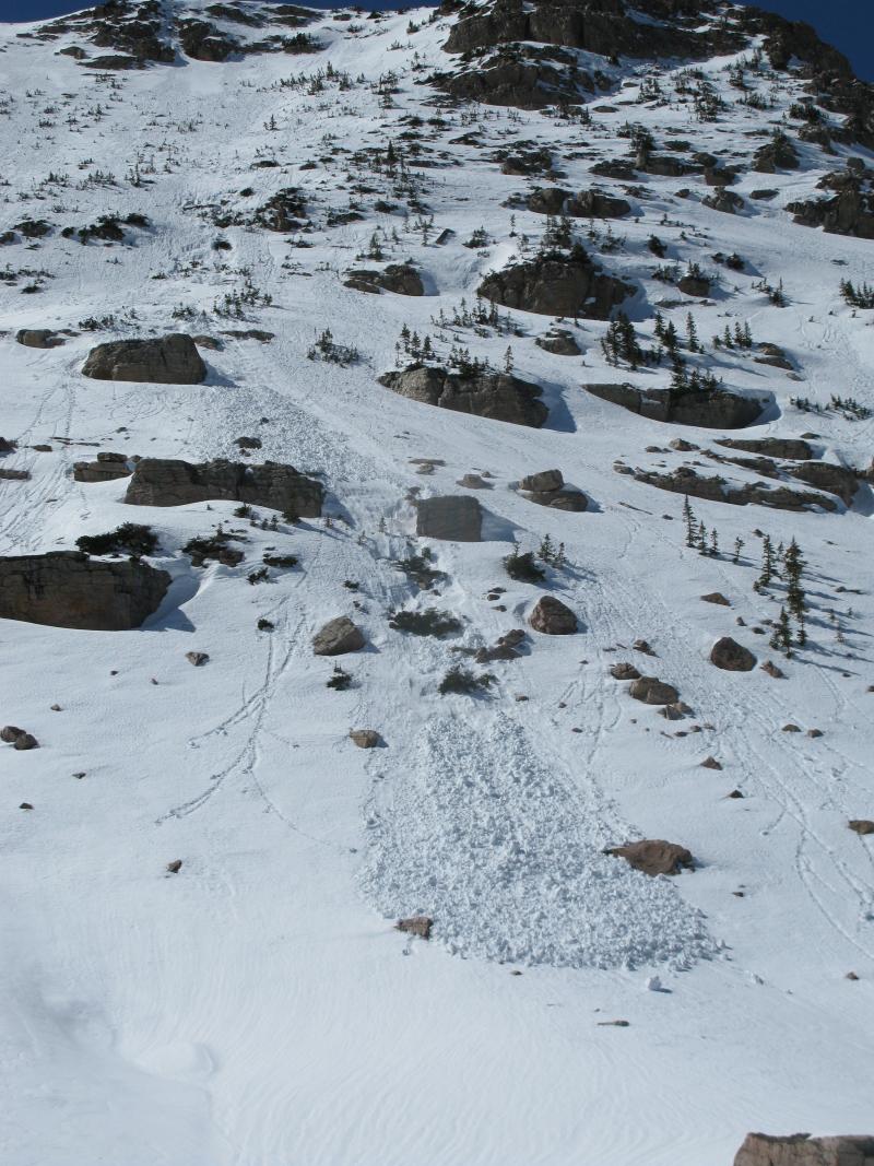
We're starting the day out quite a bit warmer and the snow surface is going to get soft and punchy in short order. None-the-less, clear skies can aid in a superficial surface freeze and I think there's a window of supportability this morning. However, the sun is high in the sky and it's not going to take long before the bottom falls out. While the avalanche danger is generally Low this morning, remember that as the surface snow heats up or if you find yourself sinking into damp, manky snow, simply move on to a cooler aspect that isn't getting baked by the intense April sun or just call it a day and move onto other things. Also, think about avoiding terrain traps like gullies or steep roads cuts, especially during the heat of the day, when even a small, seemingly harmless avalanche can stack up a surprising amount of cement-like debris.
While not particularly huge, wet slides like this one near Lofty Lake Peak have the potential to gouge deeper into the snowpack as they descend the slope, stacking up impressive piles of cement-like debris.
|
 |
weather We can expect partly cloudy skies with temperatures warming into the mid 50's. Winds shift to the southeast later today and increase slightly. Clouds thicken overnight and lows hover right around freezing. Hit or miss snow showers and perhaps a little rain starts filling in during the evening, but with a mild airmass in place, snow levels and snow densities will be on the high side. Saturday looks cloudy and warm with scattered rain and snow showers. A somewhat moist and unsettled pattern continues through much of next week.
|
| general announcements Remember your information can save lives. If you see anything we should know about, please participate in the creation of our own community avalanche advisory by submitting snow and avalanche conditions. You can call me directly at 801-231-2170, email [email protected], or email by clicking HERE If Craig is unavailable you can reach his partner Trent at 801-455-7239, email [email protected] This is a great time of year to schedule a free avalanche awareness presentation for your group or club. You can contact me at 801-231-2170 or email [email protected]. To register for the first in our series of on-the-snow sled specific classes you can register here. The information in this advisory is from the US Forest Service which is solely responsible for its content. This advisory describes general avalanche conditions and local variations always occur. The information in this advisory expires 24 hours after the date and time posted, but will be updated by 7:00 AM on Saturday, April 9th.
|