| Please join us at the 23rd annual Black Diamond Fall Fundraiser Party Thursday Sept 15. Tickets are on sale now here, at the Black Diamond store & at REI. Special bonus raffle for online ticket purchasers! |
| Please join us at the 23rd annual Black Diamond Fall Fundraiser Party Thursday Sept 15. Tickets are on sale now here, at the Black Diamond store & at REI. Special bonus raffle for online ticket purchasers! |
| Advisory: Uintas Area Mountains | Issued by Craig Gordon for Tuesday - April 5, 2016 - 4:07am |
|---|

|
bottom line As the day heats up, expect the avalanche danger to rise to MODERATE. Human triggered wet slides and sluffs become possible on all steep sunny slopes, especially during the heat of the day.
|
 |
special announcement We're starting to wrap things up for the season and this Sunday April 10th will be the last of our regularly scheduled advisories. |
 |
current conditions Skies are beginning to clear in the wake of last night's cold front, but overnight lows barely dipped to freezing at many locations. Along the high ridges it's slightly cooler, in the mid 20's, and westerly winds are blowing in the 30's and 40's. The snow surface is a mixed bag of supportable and unsupportable crusts, but if you decide to blow off working on your taxes today you can still find patches of soft settled snow on upper elevation, north facing slopes. Uinta weather station network info is found here. Trip reports and observations are found here.
|
 |
recent activity No new avalanche activity to report. Recent avalanche observations are found here See or trigger an avalanche? Shooting cracks? Hear a collapse? It's simple. Go here to fill out an observation.
|
| type | aspect/elevation | characteristics |
|---|

|
|
LIKELIHOOD
 LIKELY
UNLIKELY
SIZE
 LARGE
SMALL
TREND
 INCREASING DANGER
SAME
DECREASING DANGER
|
|
description
Clearing skies and cooling temperatures this morning will most likely provide the snow surface a superficial, albeit short-lived refreeze. While the avalanche danger is generally LOW this morning, it won't take long for the intense April sun to loosen the snow surface. Fortunately, today's avalanche danger is fairly predictable and wet slides and sluffs are pretty straight-forward. As the surface snow heats up or if you find yourself sinking into damp, manky snow, simply get off and out from under steep sun-exposed slopes.
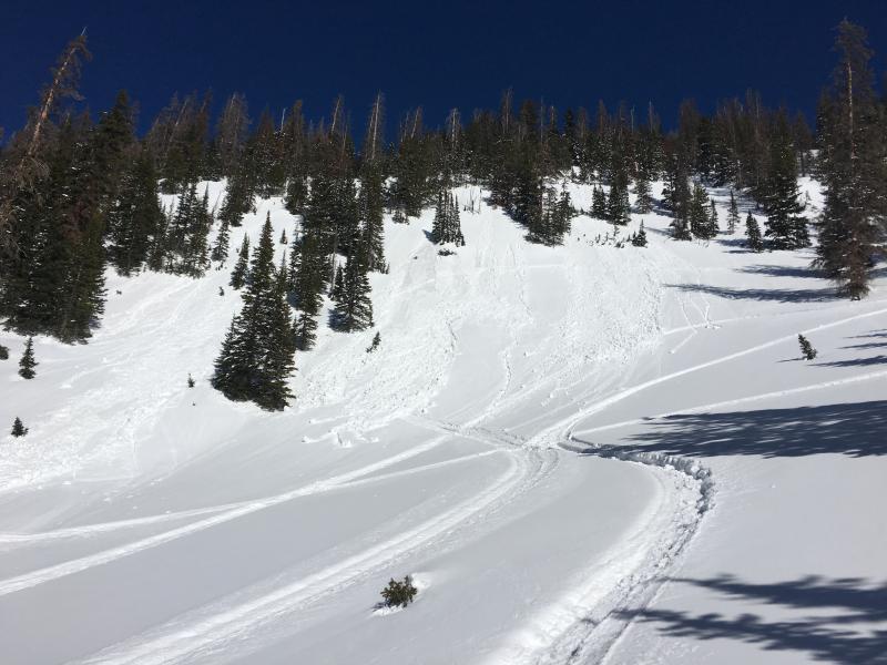
Wet avalanche activity from late in the day Saturday.
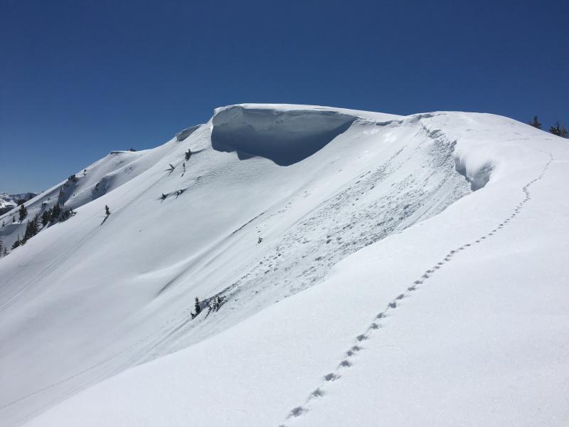
Cornices have grown large and can break a little further back than you might expect.
|
 |
weather Partly cloudy skies and cooler temperatures are on tap for us. Today's highs don't vary much from where we're at and overnight lows dip into the low 20's. West and northwest winds blow in the 30's and 40's along the high peaks. High pressure builds for the latter half of the week, producing clear skies and a warming trend.
|
| general announcements Remember your information can save lives. If you see anything we should know about, please participate in the creation of our own community avalanche advisory by submitting snow and avalanche conditions. You can call me directly at 801-231-2170, email [email protected], or email by clicking HERE If Craig is unavailable you can reach his partner Trent at 801-455-7239, email [email protected] This is a great time of year to schedule a free avalanche awareness presentation for your group or club. You can contact me at 801-231-2170 or email [email protected]. To register for the first in our series of on-the-snow sled specific classes you can register here. The information in this advisory is from the US Forest Service which is solely responsible for its content. This advisory describes general avalanche conditions and local variations always occur. The information in this advisory expires 24 hours after the date and time posted, but will be updated by 7:00 AM on Wednesday, April 6th.
|