| Please join us at the 23rd annual Black Diamond Fall Fundraiser Party Thursday Sept 15. Tickets are on sale now here, at the Black Diamond store & at REI. Special bonus raffle for online ticket purchasers! |
| Please join us at the 23rd annual Black Diamond Fall Fundraiser Party Thursday Sept 15. Tickets are on sale now here, at the Black Diamond store & at REI. Special bonus raffle for online ticket purchasers! |
| Advisory: Uintas Area Mountains | Issued by Craig Gordon for Tuesday - March 29, 2016 - 4:10am |
|---|

|
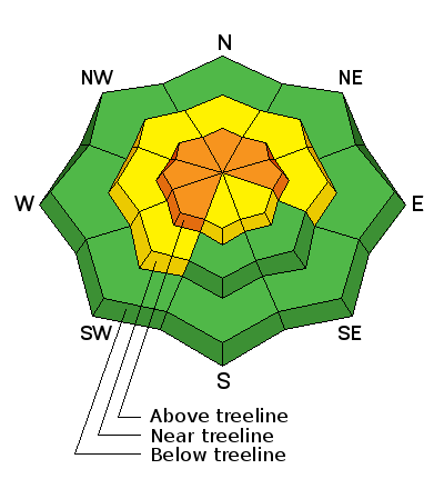
bottom line At and above treeline in the wind zone a CONSIDERABLE avalanche danger exists and human triggered avalanches are likely on all steep wind drifted slopes. Heads up- recent winds have had an easterly component to their direction, which is unusual for us, and I suspect many slopes facing west will have fresh drifts several feet deep. Mid elevation terrain offers MODERATE avalanche danger and human triggered avalanches are possible on steep slopes with recent deposits of wind drifted snow. Out of the wind the avalanche danger is generally LOW.
|
 |
special announcement Check out the Adventure and Gear Expo on April 8 & 9 at the Southtowne Expo Center. Use the code GOUAC to get a $2 discount on entrance tickets and the Adventure and Gear Expo will donate $2 to the UAC. http://www.adventuregearfest.com/ Spring powder special! We have reduced the price of donated Snowbasin lift tickets to $50 and Sundance tickets to $35, about half of window price. Take advantage of fresh powder on a fat snowpack and benefit the Utah Avalanche Center at the same time. Every penny spent on these donated tickets benefits the Utah Avalanche Center. |
 |
current conditions Yesterday's slug of moisture moving through northern Utah translated to about 9" of medium density snow in the high terrain. Temperatures remained mild overnight and in the upper 20's and low 30's. Southeast winds are the big news and they've been blowing 30-60 mph along the high ridges for the past 24 hours. On a go-anywhere base, mid elevation, wind sheltered terrain is gonna be the ticket today. Uinta weather station network info is found here. Trip reports and observations are found here.
|
 |
recent activity Shallow soft slabs breaking in the new storm snow were reported on steep wind drifted slopes yesterday afternoon. Recent avalanche observations are found here See or trigger an avalanche? Shooting cracks? Hear a collapse? It's simple. Go here to fill out an observation.
|
| type | aspect/elevation | characteristics |
|---|

|
|
LIKELIHOOD
 LIKELY
UNLIKELY
SIZE
 LARGE
SMALL
TREND
 INCREASING DANGER
SAME
DECREASING DANGER
|
|
description
A good shot of snow settled over the region yesterday and southerly winds had plenty of fresh snow to whip into wind drifts, sensitive to the additional weight of a rider. As a matter of fact, on the leeward side of upper elevation ridges and around terrain features like chutes and gullies, many steep slopes easily released before you could even get on them to ride. While not particularly deep, the sensitive nature of the new storm snow is a red flag. With more wind overnight I think today's slabs have the potential to break even deeper and wider and they'll be packing a punch. Once triggered, today's slides can easily boss you around and have the potential to quickly ruin your day. By now you know the drill- look for clues to unstable snow like shooting cracks around your skis, board, or sled and of course the most obvious... recent avalanche activity on the same types of slopes you wanna ride on.
|
 |
weather After a brief lull in the storm, snowfall intensities should increase early this morning with another 3"-6" possible. Southerly winds blow in the 40's and 50's, but decrease throughout the day. High temperatures don't vary much from where we're at this morning and dip into the teens overnight. Snow showers linger into Wednesday morning and then we start to dry out through the end of the work week.
|
| general announcements Remember your information can save lives. If you see anything we should know about, please participate in the creation of our own community avalanche advisory by submitting snow and avalanche conditions. You can call me directly at 801-231-2170, email [email protected], or email by clicking HERE If Craig is unavailable you can reach his partner Trent at 801-455-7239, email [email protected] This is a great time of year to schedule a free avalanche awareness presentation for your group or club. You can contact me at 801-231-2170 or email [email protected]. To register for the first in our series of on-the-snow sled specific classes you can register here. The information in this advisory is from the US Forest Service which is solely responsible for its content. This advisory describes general avalanche conditions and local variations always occur. The information in this advisory expires 24 hours after the date and time posted, but will be updated by 7:00 AM on Wednesday, March 30th.
|


