| Please join us at the 23rd annual Black Diamond Fall Fundraiser Party Thursday Sept 15. Tickets are on sale now here, at the Black Diamond store & at REI. Special bonus raffle for online ticket purchasers! |
| Please join us at the 23rd annual Black Diamond Fall Fundraiser Party Thursday Sept 15. Tickets are on sale now here, at the Black Diamond store & at REI. Special bonus raffle for online ticket purchasers! |
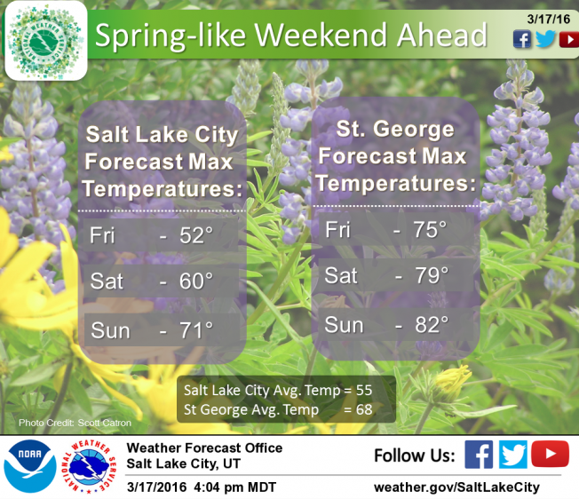
| Advisory: Uintas Area Mountains | Issued by Craig Gordon for Friday - March 18, 2016 - 4:21am |
|---|

|
bottom line In the wind zone at and above treeline, a MODERATE avalanche danger exists and human triggered avalanches are possible on steep, wind drifted slopes, especially those that face the north half of the compass. Any slide that breaks to old snow near the ground has the potential to break deeper and wider than you might expect and can quickly ruin your day. Out of the wind the avalanche danger is generally LOW.
|
 |
special announcement Huge thanks to everyone at Park City Powder Cats for your very generous donation yesterday to the Avalanche Center. I deeply appreciate our great partnership and everything you do for our organization... y'all rock!
Please help guide our discussions of website maintenance, upgrades or possible changes in coming years. Take this brief survey. As a way of saying thanks we'll be raffling a free avalanche class and other free stuff like hats, beanies, water bottles, etc. |
 |
current conditions West and southwest winds continued to crank into the 50's and 60's until about 8:00 last night when they started to relax somewhat. Currently along the high ridges, westerly winds are blowing 20-30 mph and temperatures are in the mid teens and low 20's. Our big, upper elevation, open bowls have sustained a little bit of wind damage and the snow surface is thick and slightly upside down. However, lose a little elevation, swing around to wind sheltered, north facing terrain and you'll be treated to soft, creamy snow on a go-anywhere base. If you're confused by avalanche danger ratings, you're not alone. Check out a slick viddy describing how it all works.
Uinta weather station network info is found here. Trip reports and observations are found here.
|
 |
recent activity One report of a rider triggered slab breaking up to 2' deep and 40' wide on a steep leeward slope in the wind zone. Otherwise... no news of the weird. Recent avalanche observations are found here See or trigger an avalanche? Shooting cracks? Hear a collapse? It's simple. Go here to fill out an observation.
|
| type | aspect/elevation | characteristics |
|---|

|
|
LIKELIHOOD
 LIKELY
UNLIKELY
SIZE
 LARGE
SMALL
TREND
 INCREASING DANGER
SAME
DECREASING DANGER
|
|
description
I think a lot of our wind drift issues are starting to relax somewhat and the snowpack is feeling comfortable in its own skin. Yesterday while I was out, I found pockety wind slabs, but they were isolated to steep, leeward terrain in the wind zone. While today's slabs might be a little stubborn, once triggered they'll have some mass behind them and they'll be packing a punch. If you're travels take you into big, upper elevation terrain today... ride defensively. You're best plan of attack is avoiding any fat, rounded piece of snow, especially if it sounds or feels hollow like a drum.
Cornices have grown quite large the past few days and may break back further than you might expect. Best to avoid being on or underneath these boxcar sized pieces of snow.
|
| type | aspect/elevation | characteristics |
|---|

|
|
LIKELIHOOD
 LIKELY
UNLIKELY
SIZE
 LARGE
SMALL
TREND
 INCREASING DANGER
SAME
DECREASING DANGER
|
|
description
Less obvious and certainly more dangerous is the possibility of triggering an avalanche that breaks to sugary snow near the ground. While not widespread, fact is, we still have terrain that harbors weak snow. The usual suspects come to mind... steep, upper elevation, north facing slopes, especially those with a thin, weak snowpack need to be carefully evaluated or better yet, simply avoid terrain with these characteristics.
|
 |
weather High pressure is building and we'll see mostly sunny skies with temperatures rising into the mid 30's and overnight lows in the 20's. West and northwest winds blow in the 40's along the high ridges, but diminish this morning and back off into the mid 20's by midday. A strong warming trend is on tap for Saturday and continues into Sunday, before unsettled weather returns for early next week.
|
| general announcements Remember your information can save lives. If you see anything we should know about, please participate in the creation of our own community avalanche advisory by submitting snow and avalanche conditions. You can call me directly at 801-231-2170, email [email protected], or email by clicking HERE If Craig is unavailable you can reach his partner Trent at 801-455-7239, email [email protected] This is a great time of year to schedule a free avalanche awareness presentation for your group or club. You can contact me at 801-231-2170 or email [email protected]. To register for the first in our series of on-the-snow sled specific classes you can register here. The information in this advisory is from the US Forest Service which is solely responsible for its content. This advisory describes general avalanche conditions and local variations always occur. The information in this advisory expires 24 hours after the date and time posted, but will be updated by 7:00 AM on Saturday, March 19th.
|