| Please join us at the 23rd annual Black Diamond Fall Fundraiser Party Thursday Sept 15. Tickets are on sale now here, at the Black Diamond store & at REI. Special bonus raffle for online ticket purchasers! |
| Please join us at the 23rd annual Black Diamond Fall Fundraiser Party Thursday Sept 15. Tickets are on sale now here, at the Black Diamond store & at REI. Special bonus raffle for online ticket purchasers! |
| Advisory: Uintas Area Mountains | Issued by Trent Meisenheimer for Monday - March 14, 2016 - 5:22am |
|---|

|
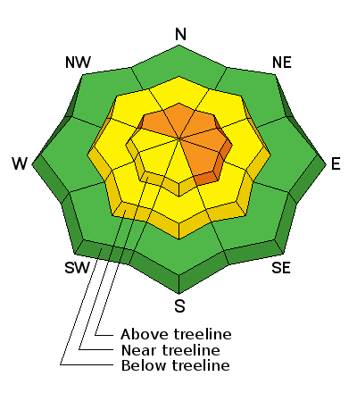
bottom line In the wind zone at and above treeline, a CONSIDERABLE avalanche danger exists and human triggered avalanches are likely on steep, wind drifted slopes, especially those that face the north half of the compass . Any slide that breaks to old snow near the ground will be deep and dangerous. Mid elevation terrain offers MODERATE avalanche danger and human triggered avalanche are possible on steep slopes with recent deposits of wind drifted snow. Still want to ride pow and have a great day? It's easy.... tone down your slope angles or simply boondock in the trees and meadows far away from anything steep.
|
 |
current conditions Today will be a day of increasing avalanche danger throughout the range. We have a cold pacific storm on our door step this morning and the southerly winds are blowing 30 mph and gusting into the 50's and 60's along the high elevation terrain. Overnight we picked up 1-2 inches of new snow and temperatures are hovering in the upper 20's at 10,000 feet. If you're confused by avalanche danger ratings, you're not alone. Check out a slick viddy describing how it all works.
Uinta weather station network info is found here. Trip reports and observations are found here.
|
 |
recent activity No new avalanche activity reported yesterday. However, John Mletschnig has a great observation found here Recent avalanche observations are found here See or trigger an avalanche? Shooting cracks? Hear a collapse? It's simple. Go here to fill out an observation.
|
| type | aspect/elevation | characteristics |
|---|

|
|
LIKELIHOOD
 LIKELY
UNLIKELY
SIZE
 LARGE
SMALL
TREND
 INCREASING DANGER
SAME
DECREASING DANGER
|
|
description
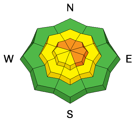
The most obvious in your face danger today will be wind slabs. Today's wind and new snow will rapidly form fresh drifts sensitive to the additional weight of a rider. They will be most pronounced on slopes that face northwest through southeast at upper elevations. Today's slabs may break deeper and wider than you might expect and could knock you off your skis, board or sled.
|
| type | aspect/elevation | characteristics |
|---|

|
|
LIKELIHOOD
 LIKELY
UNLIKELY
SIZE
 LARGE
SMALL
TREND
INCREASING DANGER
SAME
DECREASING DANGER
|
|
description
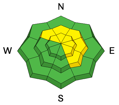
Less obvious and certainly more dangerous is the possibility of triggering an avalanche that breaks to old, weak, sugary snow near the ground. We still have places that harbor shallow weak snow in the range and this weeks storm will be a good test on these buried weak layers. I would avoid any steep, upper elevation terrain, especially if it faces the north half of the compass, and particularly if it's thin and rocky. Any slide that breaks to old snow is going to be deep and wide, quickly ruining your day. Stick to simple terrain like open meadows or tight trees, with nothing hanging overhead.
Photo of weak sugary (faceted) snow found yesterday by John Mletschnig in the Mill Creek drainage. This photo is a good example of the weak snow still at the ground in many locations. |
 |
weather Winds will continue to blow into the 30's and 40's from the south before they eventually switch and start to blow from the northwest later this morning. Temperatures will drop 10-15 degrees as a result of the cold air that arrives with this storm system. A winter storm warning is in effect throughout the range today and into tomorrow. Snow will start to fall and accumulate today and through much of the evening as a moist and somewhat unstable west-northwest flow remains in place. This should be a good shot of snow for the Uinta's and 8-16 inches of new snow by late Tuesday is a good bet.
|
| general announcements Remember your information can save lives. If you see anything we should know about, please participate in the creation of our own community avalanche advisory by submitting snow and avalanche conditions. You can call me directly at 801-231-2170, email [email protected], or email by clicking HERE If Craig is unavailable you can reach his partner Trent at 801-455-7239, email [email protected] This is a great time of year to schedule a free avalanche awareness presentation for your group or club. You can contact me at 801-231-2170 or email [email protected]. To register for the first in our series of on-the-snow sled specific classes you can register here. The information in this advisory is from the US Forest Service which is solely responsible for its content. This advisory describes general avalanche conditions and local variations always occur. The information in this advisory expires 24 hours after the date and time posted, but will be updated by 7:00 AM on Tuesday, March 15th.
|