| Please join us at the 23rd annual Black Diamond Fall Fundraiser Party Thursday Sept 15. Tickets are on sale now here, at the Black Diamond store & at REI. Special bonus raffle for online ticket purchasers! |
| Please join us at the 23rd annual Black Diamond Fall Fundraiser Party Thursday Sept 15. Tickets are on sale now here, at the Black Diamond store & at REI. Special bonus raffle for online ticket purchasers! |
| Advisory: Uintas Area Mountains | Issued by Craig Gordon for Saturday - March 12, 2016 - 4:42am |
|---|

|
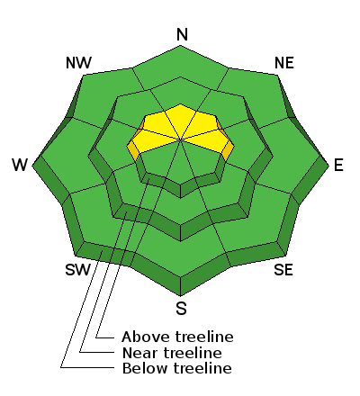
bottom line Most terrain throughout the range offers LOW avalanche danger. However, while it makes up a small portion of the terrain available to ride today, pockets of MODERATE avalanche danger exist and human triggered avalanches are possible, especially on steep, wind drifted slopes and particularly in terrain with a thin, weak snowpack. While it's becoming more the exception than the rule, any avalanche that fails on weak, sugary snow near the ground, has the potential to break deeper and wider than you might expect. If you're confused by avalanche danger ratings, you're not alone. Click here to check out a slick viddy describing how it all works.
|
 |
current conditions A thick blanket of clouds rolled into the region yesterday, lingering through the night. A brief shot of moisture slid through overnight as well. Hard to say exactly, but there might be a trace to an inch of new snow. Temperatures are in the upper 20's and southerly winds are blowing 30-50 mph along the high ridges. Snow surface conditions run the gamut of supportable and unsupportable crusts. I think you'll find a short-lived window of corn on low and mid elevation south aspects with shallow powder still lingering on high elevation north facing slopes. Everything in-between offers character building potential. Uinta weather station network info is found here. Trip reports and observations are found here.
|
 |
recent activity A few shallow wind drifts sensitive to the additional weight of a rider were reported in steep, upper elevation, leeward terrain. Otherwise... pretty quiet on the eastern front. Recent avalanche observations are found here See or trigger an avalanche? Shooting cracks? Hear a collapse? It's simple. Go here to fill out an observation.
|
| type | aspect/elevation | characteristics |
|---|

|
|
LIKELIHOOD
 LIKELY
UNLIKELY
SIZE
 LARGE
SMALL
TREND
 INCREASING DANGER
SAME
DECREASING DANGER
|
|
description
Upper elevation, southerly winds have been cranking into the 40's and 50's since about midmorning Friday. When it comes to wind, the Uinta's never disappoint. As a matter of fact, the range is an overachiever. Even when I think all the new snow has been baked in place by strong spring sunshine and warm temperatures, Uinta-esque wind rakes the the high ridges and channels through terrain features, finding just enough loose snow to whip into fresh wind slabs. The good news is... today's shallow slabs are confined to the highest, leeward terrain throughout the range and in general these are manageable, easy to detect, and easier to avoid. Lose a little elevation, you lose the problem, and you're treated to soft settled snow. Done and done. In addition to fresh drifts, a rogue slab breaking into weak snow near the ground isn't out of the question and our usual suspects come to mind... steep, rocky terrain with a shallow, weak snowpack. Any slide that breaks to weak snow near the ground has the potential to quickly ruin your day.
|
 |
weather A few lingering snow showers hang over the region this morning, but accumulations will be negligible. By early afternoon, skies become partly cloudy and temperatures bump into the mid and upper 30's. Southwest winds diminish somewhat, blowing in the 30's and 40's along the high ridges. Under clearing skies, temperatures dip into the mid 20's overnight. A weak system rolls through the region Sunday afternoon, followed by a stronger storm late Monday. While the computer models sort through the exact details, it looks like a colder, wetter pattern for the beginning of the work week is a good bet.
|
| general announcements Remember your information can save lives. If you see anything we should know about, please participate in the creation of our own community avalanche advisory by submitting snow and avalanche conditions. You can call me directly at 801-231-2170, email [email protected], or email by clicking HERE If Craig is unavailable you can reach his partner Trent at 801-455-7239, email [email protected] This is a great time of year to schedule a free avalanche awareness presentation for your group or club. You can contact me at 801-231-2170 or email [email protected]. To register for the first in our series of on-the-snow sled specific classes you can register here. The information in this advisory is from the US Forest Service which is solely responsible for its content. This advisory describes general avalanche conditions and local variations always occur. The information in this advisory expires 24 hours after the date and time posted, but will be updated by 7:00 AM on Sunday, March 13th.
|


