| Please join us at the 23rd annual Black Diamond Fall Fundraiser Party Thursday Sept 15. Tickets are on sale now here, at the Black Diamond store & at REI. Special bonus raffle for online ticket purchasers! |
| Please join us at the 23rd annual Black Diamond Fall Fundraiser Party Thursday Sept 15. Tickets are on sale now here, at the Black Diamond store & at REI. Special bonus raffle for online ticket purchasers! |
| Advisory: Uintas Area Mountains | Issued by Craig Gordon for Thursday - March 3, 2016 - 4:12am |
|---|


|
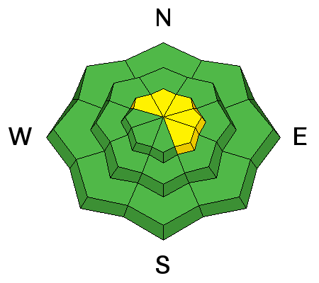
bottom line While the avalanche danger is generally LOW, pockets of MODERATE avalanche danger exist on steep, upper elevation, leeward slopes, especially those facing the north half of the compass. Remember- any avalanche that fails on weak, sugary snow near the ground, has the potential to break deeper and wider than you might expect.
|
 |
special announcement The Utah Avalanche Center greatly values in longtime partnership with our world-class resorts and is blowing out the remaining donated lift tickets from Alta, Snowbird, Snowbasin, Sundance, and Nordic Valley with reduced prices. Every penny you spend and turn you make benefits the Utah Avalanche Center. Check out our Garage Sale! Chock full of sweet backcountry gear - you can find the goods on our Facebook page here. |
 |
current conditions Skies are partly cloudy, temperatures in the mid 20's, and westerly winds finally relaxed late Wednesday and are currently blowing 20-30 mph along the high peaks. The past few storms only added a few inches to our snowpack, but have helped fill in some of the old ruts and heavy traffic in popular areas. Billiard table smoothness is found on south facing terrain and on the other side of the compass, soft, creamy powder. Uinta weather station network info is found here. Trip reports and observations are found here.
|
 |
recent activity A handful of shallow wind drifts were spotted on steep, leeward slopes above treeline. Recent avalanche observations are found here See or trigger an avalanche? Shooting cracks? Hear a collapse? It's simple. Go here to fill out an observation.
|
| type | aspect/elevation | characteristics |
|---|

|
|
LIKELIHOOD
 LIKELY
UNLIKELY
SIZE
 LARGE
SMALL
TREND
 INCREASING DANGER
SAME
DECREASING DANGER
|
|
description
Most of our wind drift issues seem so yesterday and I think today you'll find them pretty well behaved and predictable. Of course, if you're getting into steep, unforgiving, radical terrain remember- even a small slide can knock you off your feet or sled and take you for a fast, body bruising ride into trees or over a cliff band. Found on steep, leeward slopes in the wind zone, above treeline, today's shallow slabs are easy to detect by their fat, rounded appearance and easy to avoid. Simply lose a little elevation and you'll lose the problem.
Ted found this shallow slab in the wind zone around Bald Mountain yesterday. Less predictable, is any slide that fails on weak, sugary snow near the ground, or what we call persistent slabs. Remember- persistent slabs have the potential to break deeper and wider than you might expect. Steep, rocky terrain facing the north half of the compass and particularly slopes that avalanched near the ground earlier this season should be considered suspect.
Breaking deeper and certainly less predictable, is any avalanche that fails on weak snow near the ground like this sled triggered slab in Gold Hill Basin last week.
|
 |
weather High, thin clouds hang over the mountains, as yet another weak little system starts sliding into the region tonight. In the meantime, it'll be a beautiful day with temperatures rising into the low 50's and westerly winds blowing 15-25 mph along the high ridges. A few flurries are possible tonight and overnight lows dip into the low 30's. A break in the action for Friday and then Saturday looks warm and windy as a moist storm sets its sights on the region, ushering in a round of snow for Sunday through Sunday evening. 6-12 inches of high density snow by late Sunday looks like a good bet.
|
| general announcements Remember your information can save lives. If you see anything we should know about, please participate in the creation of our own community avalanche advisory by submitting snow and avalanche conditions. You can call me directly at 801-231-2170, email [email protected], or email by clicking HERE If Craig is unavailable you can reach his partner Trent at 801-455-7239, email [email protected] This is a great time of year to schedule a free avalanche awareness presentation for your group or club. You can contact me at 801-231-2170 or email [email protected]. To register for the first in our series of on-the-snow sled specific classes you can register here. The information in this advisory is from the US Forest Service which is solely responsible for its content. This advisory describes general avalanche conditions and local variations always occur. The information in this advisory expires 24 hours after the date and time posted, but will be updated by 7:00 AM on Friday, March 4th.
|


