| Please join us at the 23rd annual Black Diamond Fall Fundraiser Party Thursday Sept 15. Tickets are on sale now here, at the Black Diamond store & at REI. Special bonus raffle for online ticket purchasers! |
| Please join us at the 23rd annual Black Diamond Fall Fundraiser Party Thursday Sept 15. Tickets are on sale now here, at the Black Diamond store & at REI. Special bonus raffle for online ticket purchasers! |
| Advisory: Uintas Area Mountains | Issued by Craig Gordon for Wednesday - February 24, 2016 - 5:34am |
|---|

|
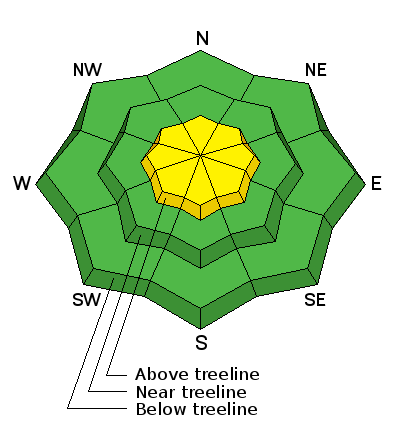
bottom line While not widespread, pockets of MODERATE avalanche danger exist on steep, leeward slopes in the wind zone, at and above treeline. While it's becoming more the exception than the rule, any avalanche that breaks to weak, sugary snow near the ground, has the potential to break deeper and wider than you might expect. Out of the wind the avalanche danger is generally LOW.
|
 |
special announcement Thursday 2/25 - Utah Adventure Journal presents adventure photographer Jim Harris at Snowbird's Wildflower Lounge. More Details Here. Check out our Garage Sale! Chock full of sweet backcountry gear - you can find the goods on our Facebook page here. |
 |
current conditions Wow... what an amazing moon out there this morning! Clear skies allowed temperatures to fall into the single digits and low teens and southwest winds ramped up around 10:00 last night, they're currently blowing 20-30 mph along the high peaks. Monday's little storm went a long way, greatly improving riding and turning conditions.
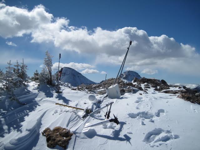
Man down! Last Thursday's winds gusting to over a 100 mph were too much for one of our automated weather sites. Huge thanks to Ted Scroggin for the Herculean effort yesterday getting the Lofty Lake Peak wind site dusted off, upright, and back online again. Uinta weather station network info is found here.
On the other side of the coin. Man up... then down... then up... and down again. Locals are taking advantage of stable snow conditions and getting into big Uinta terrain. Trip reports and observations are found here.
|
 |
recent activity
A few shallow, yet very manageable fresh drifts and sluffs were noted along the leeward side of upper elevation ridges. Recent avalanche observations are found here See or trigger an avalanche? Shooting cracks? Hear a collapse? It's simple. Go here to fill out an observation.
|
| type | aspect/elevation | characteristics |
|---|

|
|
LIKELIHOOD
 LIKELY
UNLIKELY
SIZE
 LARGE
SMALL
TREND
 INCREASING DANGER
SAME
DECREASING DANGER
|
|
description
Northwest winds are expected to ramp up throughout the day and they'll have no problem forming shallow slabs along the leeward side of upper elevation ridges. In general, today's wind drifts are manageable in size and predictably break at or below your skis, board, or sled. Remember- if you're travels take you into steep, unforgiving terrain, think about the consequences and keep in mind, even a small slide can easily boss you around.
|
 |
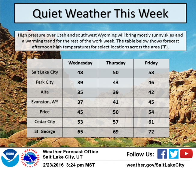
weather It'll be a beautiful day in the mountains. Look for mostly sunny skies with temperatures climbing into the mid 30's. Northwest winds might become a nuisance as the day wares on with average speeds in the 30's and gusts in the 40's and 50's along the high peaks. Quiet weather and a warming trend is on tap for the remainder of the work week. A weak storm is slated for Saturday.
|
| general announcements Remember your information can save lives. If you see anything we should know about, please participate in the creation of our own community avalanche advisory by submitting snow and avalanche conditions. You can call me directly at 801-231-2170, email [email protected], or email by clicking HERE If Craig is unavailable you can reach his partner Trent at 801-455-7239, email [email protected] This is a great time of year to schedule a free avalanche awareness presentation for your group or club. You can contact me at 801-231-2170 or email [email protected]. To register for the first in our series of on-the-snow sled specific classes you can register here. The information in this advisory is from the US Forest Service which is solely responsible for its content. This advisory describes general avalanche conditions and local variations always occur. The information in this advisory expires 24 hours after the date and time posted, but will be updated by 7:00 AM on Thursday, February 25th.
|