| Please join us at the 23rd annual Black Diamond Fall Fundraiser Party Thursday Sept 15. Tickets are on sale now here, at the Black Diamond store & at REI. Special bonus raffle for online ticket purchasers! |
| Please join us at the 23rd annual Black Diamond Fall Fundraiser Party Thursday Sept 15. Tickets are on sale now here, at the Black Diamond store & at REI. Special bonus raffle for online ticket purchasers! |
| Advisory: Uintas Area Mountains | Issued by Craig Gordon for Saturday - February 20, 2016 - 4:27am |
|---|

|
bottom line In the wind zone, at and above treeline, a MODERATE avalanche danger exists and human triggered slides are possible on steep, wind drifted slopes. While it's becoming more the exception than the rule, any avalanche that breaks to weak, sugary snow near the ground, has the potential to be deep and dangerous.
|
 |
special announcement Here's a great new video which defines responsibilty to ourselves and others in the backcountry- Backcountry Responsibility Objective from Trent Meisenheimer on Vimeo. |
 |
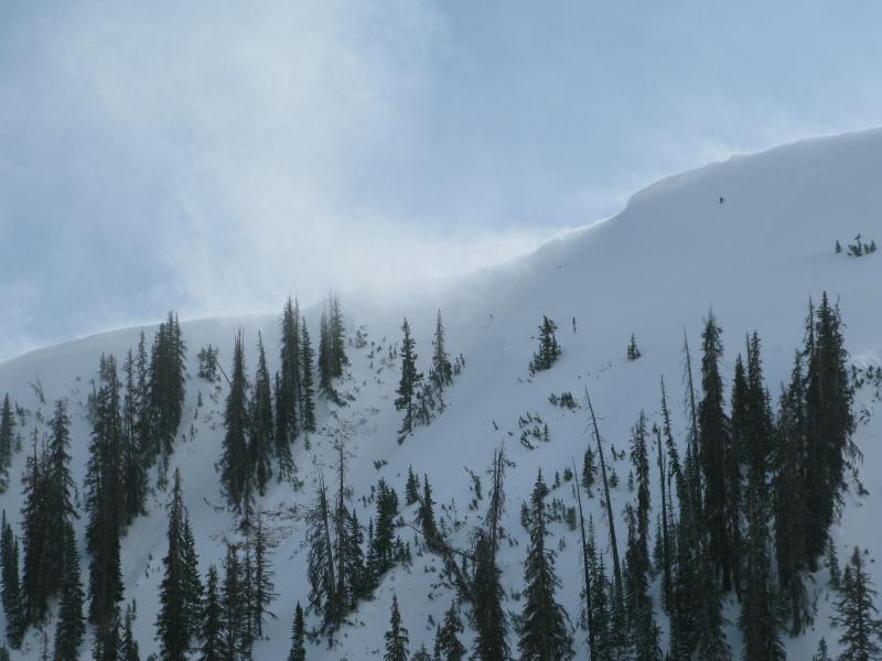
current conditions High clouds drifted into the region overnight, as a weak system slides through the north half of the state. Current temperatures are in the mid 20 to upper 20's and west-southwest winds are blowing 20-40 mph along the high peaks. Thursdays storm helped freshen things up somewhat and today you'll still find soft, settled snow in wind sheltered, shady terrain.
JG kills it with his pit profiles. Here you can clearly see our current snowpack setup. More on his travels are found here.
Heads up! Thursday's ferocious winds toppled trees throughout the range. Probably a good idea to have a saw handy in case you find yourself dead-ended in the woods. Trip reports and observations are found here.
|
 |
recent activity A few shallow, yet very manageable fresh drifts were noted along the leeward side of upper elevation ridges. Recent avalanche observations are found here See or trigger an avalanche? Shooting cracks? Hear a collapse? It's simple. Go here to fill out an observation.
|
| type | aspect/elevation | characteristics |
|---|

|
|
LIKELIHOOD
 LIKELY
UNLIKELY
SIZE
 LARGE
SMALL
TREND
 INCREASING DANGER
SAME
DECREASING DANGER
|
|
description
Yesterday's west and southwest winds blew in the 40's and 50's along the high peaks, and had no problem finding enough loose snow to whip into fresh drifts, sensitive to the additional weight of a rider. Manageable in size and predictably breaking at or below your skis, board, or sled, I think this will be the theme again today. The good news is, this is a pretty straight-forward avalanche problem, because if you lose a little elevation... you'll lose the problem.
Yesterday's winds rapidly formed drifts along the leeward side of upper elevation ridges.
|
| type | aspect/elevation | characteristics |
|---|

|

|
LIKELIHOOD
 LIKELY
UNLIKELY
SIZE
 LARGE
SMALL
TREND
INCREASING DANGER
SAME
DECREASING DANGER
|
|
description
It's been a week since we've seen or heard of any avalanche activity breaking to weak snow near the ground. As a matter of fact, the last reported deep slab avalanche was in Race Track Bowl on February 13th... more details here . While most of our terrain is turning the corner towards a homogenous, predictable snowpack, there's still isolated areas where strong, solid feeling snow rests on top of weak, sugary snow near the ground. Of course, our usual suspects come to mind, in particular, steep rocky terrain and slopes that previously avalanched during the Solstice Storm and have remained shallow all season. It's not full on green light conditions out there today and I'd continue to carefully evaluate any steep slope with these characteristics.
|
 |
weather A weak weather system ushers in a few clouds and maybe a couple of flakes, but I don't expect we'll see much accumulation, as the bulk of the storm is north of the region. West and southwest winds are going to be a nuisance, gusting into the 40's and 50's along the high peaks. Temperatures don't vary much from where we're at this morning and under partly cloudy skies tonight, they should dip into the low 20's. A break is slated for Sunday with a better shot of snow shaping up for late Monday and Tuesday.
|
| general announcements Remember your information can save lives. If you see anything we should know about, please participate in the creation of our own community avalanche advisory by submitting snow and avalanche conditions. You can call me directly at 801-231-2170, email [email protected], or email by clicking HERE If Craig is unavailable you can reach his partner Trent at 801-455-7239, email [email protected] This is a great time of year to schedule a free avalanche awareness presentation for your group or club. You can contact me at 801-231-2170 or email [email protected]. To register for the first in our series of on-the-snow sled specific classes you can register here. The information in this advisory is from the US Forest Service which is solely responsible for its content. This advisory describes general avalanche conditions and local variations always occur. The information in this advisory expires 24 hours after the date and time posted, but will be updated by 7:00 AM on Sunday, February 21st.
|