| Please join us at the 23rd annual Black Diamond Fall Fundraiser Party Thursday Sept 15. Tickets are on sale now here, at the Black Diamond store & at REI. Special bonus raffle for online ticket purchasers! |
| Please join us at the 23rd annual Black Diamond Fall Fundraiser Party Thursday Sept 15. Tickets are on sale now here, at the Black Diamond store & at REI. Special bonus raffle for online ticket purchasers! |
| Advisory: Uintas Area Mountains | Issued by Trent Meisenheimer for Thursday - February 18, 2016 - 5:13am |
|---|

|
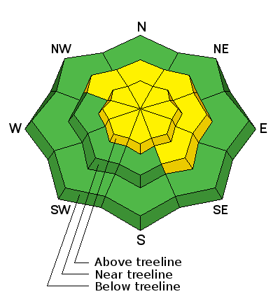
bottom line At and above treeline, a MODERATE avalanche danger exists and human triggered avalanches are possible on steep slopes, especially those with recent deposits of wind drifted snow. Any avalanche that breaks to weak, sugary snow near the ground has the potential to be deep and dangerous.
|
 |
special announcement Huge thanks to Wellers Recreation for hosting last nights companion rescue class and to Andy, Tyler, Jimmy, Patrick, Trace, and Kelsey for taking time out of their busy lives to make it happen. Here's a great new video which defines responsibilty to ourselves and others in the backcountry- Backcountry Responsibility Objective from Trent Meisenheimer on Vimeo. |
 |
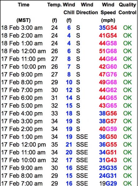
current conditions The wind is the big news this morning - south winds are blowing 40-50mph and gusting into the 70's at the 10,000' ridge lines. We have picked up 2-3 inches of new snow overnight and temperatures remain on the warm side with most trail heads at or near 32 deg. Higher up around 10,000ft the temperature has cooled a bit and is 27 deg. The snow surface yesterday made me think I was walking on the moon.
Wind speeds at 10,600ft in elevation.
Trip reports and observations are found here.
|
 |
recent activity No new avalanche activity was reported yesterday. Recent avalanche observations are found here See or trigger an avalanche? Shooting cracks? Hear a collapse? It's simple. Go here to fill out an observation.
|
| type | aspect/elevation | characteristics |
|---|

|
|
LIKELIHOOD
 LIKELY
UNLIKELY
SIZE
 LARGE
SMALL
TREND
 INCREASING DANGER
SAME
DECREASING DANGER
|
|
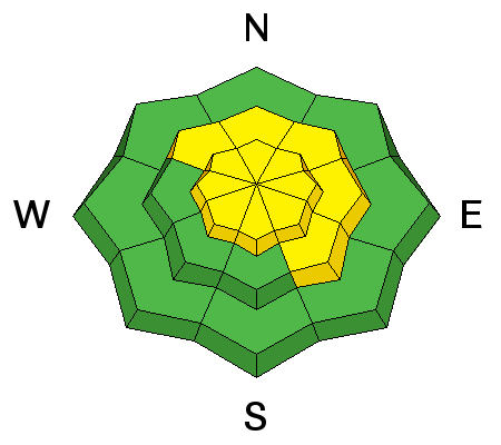
description
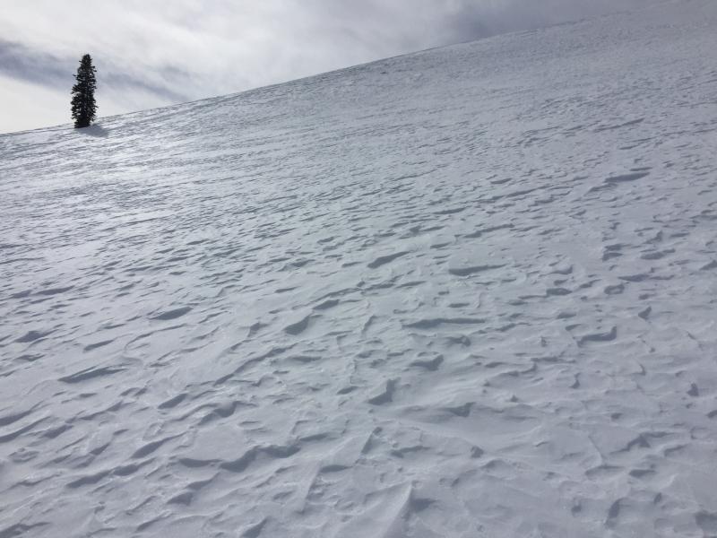
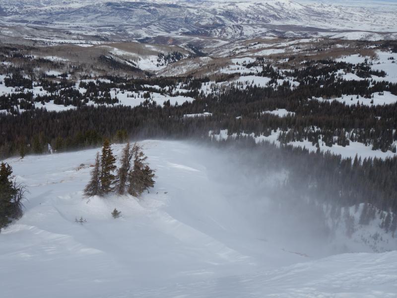
The winds are howling this morning and should continue throughout most of the day. If you find yourself at or above tree line and on terrain steeper than 35 degrees - be on the lookout for fresh drifts of wind blown snow on any terrain feature, this includes gulleys, road cuts, chutes, break overs, and creek bottoms. They should be easy to spot - fresh drifts will look rounded and pillowy. These new drifts of snow will be sensitive to the weight of a rider and could be up to a couple of feet deep. I would expect to find these drifts in unusual places due to the very strong winds. The good news is that wind slabs settle out very quickly and by the weekend they will likely not be a problem. As for today the best bet would be to leave them alone. Picture taken yesterday as the winds started to move the snow around. (Kikkert Photo)
|
| type | aspect/elevation | characteristics |
|---|

|
|
LIKELIHOOD
 LIKELY
UNLIKELY
SIZE
 LARGE
SMALL
TREND
 INCREASING DANGER
SAME
DECREASING DANGER
|
|
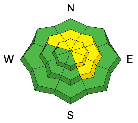
description
Today's wind slabs will be the biggest concern, they will also be the most obvious and manageable avalanche problem. However, don't forget... even a small slide can get quickly out of hand if it breaks to weak sugary snow near the ground. And yes, while it's becoming harder to trigger a deep, dangerous avalanche, we're still finding places that have weak sugary snow, with stronger, more dense snow resting on top. Steep, mid and upper elevation terrain that faces the north half of the compass, and particularly slopes that previously avalanched during the big Solstice Storm should be considered suspect and still need to be carefully evaluated.
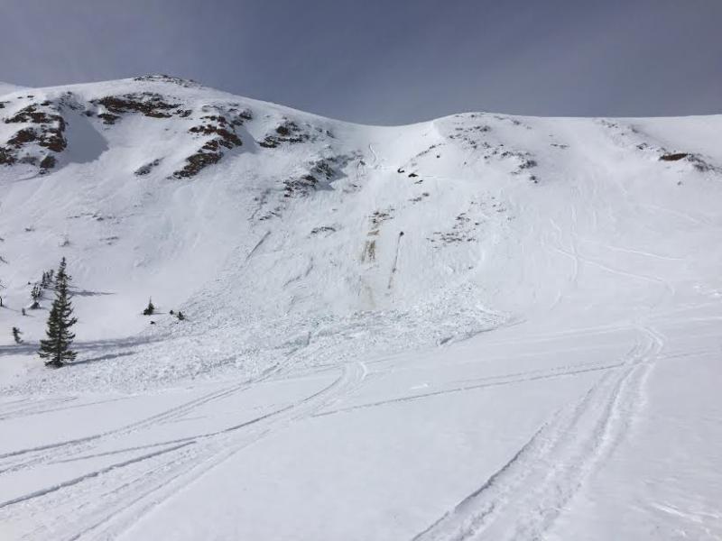
Here's a great example of a shallow slide that breaks to weak snow, deeper in the snowpack. This sled triggered avalanche in Race Track Bowl occurred on Feb. 13th and it's what we call a "repeater"... meaning it slid earlier in the season.
|
 |
weather A strong and fast moving storm is on our door step this morning. Winds will continue to blow into the 30's and 40's out of the south before switching to the west as the storm arrives. Temperatures will drop and we should see some snow starting around the noon hour. The snow will be dense and heavy, and we should see about 3-6 inches of new snow when it's all said and done. The storm system exits the area by the early evening hours. Friday and Saturday look to be partly cloudy with hopefully another small storm moving in on Sunday evening into Monday.
|
| general announcements Remember your information can save lives. If you see anything we should know about, please participate in the creation of our own community avalanche advisory by submitting snow and avalanche conditions. You can call me directly at 801-231-2170, email [email protected], or email by clicking HERE If Craig is unavailable you can reach his partner Trent at 801-455-7239, email [email protected] This is a great time of year to schedule a free avalanche awareness presentation for your group or club. You can contact me at 801-231-2170 or email [email protected]. To register for the first in our series of on-the-snow sled specific classes you can register here. The information in this advisory is from the US Forest Service which is solely responsible for its content. This advisory describes general avalanche conditions and local variations always occur. The information in this advisory expires 24 hours after the date and time posted, but will be updated by 7:00 AM on Friday, February 19th.
|