| Please join us at the 23rd annual Black Diamond Fall Fundraiser Party Thursday Sept 15. Tickets are on sale now here, at the Black Diamond store & at REI. Special bonus raffle for online ticket purchasers! |
| Please join us at the 23rd annual Black Diamond Fall Fundraiser Party Thursday Sept 15. Tickets are on sale now here, at the Black Diamond store & at REI. Special bonus raffle for online ticket purchasers! |
| Advisory: Uintas Area Mountains | Issued by Craig Gordon for Sunday - February 7, 2016 - 5:24am |
|---|

|
bottom line At and above treeline, especially in the wind zone, a MODERATE avalanche danger exists and human triggered avalanches are possible on steep, wind drifted slopes. Any avalanche that breaks to weak, sugary snow near the ground has the potential to be deep and dangerous. Remember- MODERATE avalanche danger means we can still trigger large avalanches in isolated areas. Wind sheltered terrain that is under 30 degrees in slope steepness is the ticket for finding both LOW avalanche danger and great riding conditions.
|
 |
special announcement Today should be a spectacular day in the mountains with great riding conditions. However, if you're getting out on the snow, make sure your crew wears and knows how to use basic rescue gear - beacon, shovel, and probe. Last year the Utah Avalanche Center alongside many great partners (Boondockers, Alpine Assassins, ISMA) put together a video called " Knowledge Is Powder " it's worth watching. Knowledge Is Powder - Snowmobiling from Trent Meisenheimer on Vimeo. |
 |
current conditions High pressure is building and skies cleared overnight, with temperatures hovering in the upper teens and low 20's. West and northwest winds ramped midday Saturday and are currently blowing 25-35 mph along the ridges, with gusts in the 40's near the high peaks. As valley inversions set in, it'll be a stunning day in the mountains, where the air is clear, the riding conditions are five star, and the travel is easy.
Excellent riding and turning conditions are found in wind sheltered terrain. Trip reports and observations are found here.
|
 |
recent activity
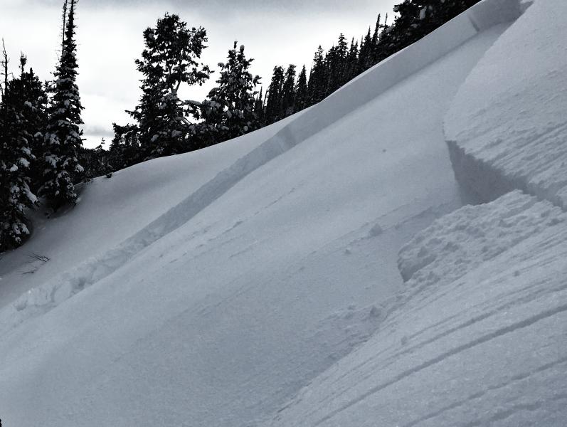
Bordering on manageable, this storm slab broke a couple feet deep, on a steep, cross-loaded, east-southeast facing aspect. Fortunately the rider read the terrain, was quick on his feet, and pulled off to an island of safety. (Provo photo) Recent avalanche observations are found here. See or trigger an avalanche? Shooting cracks? Hear a collapse? It's simple. Go here to fill out an observation.
|
| type | aspect/elevation | characteristics |
|---|

|
|
LIKELIHOOD
 LIKELY
UNLIKELY
SIZE
 LARGE
SMALL
TREND
 INCREASING DANGER
SAME
DECREASING DANGER
|
|
description
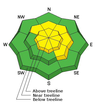
West and northwest winds increased yesterday and overnight, finding enough loose snow to blow around and form shallow slabs that'll be sensitive to the additional weight of a rider. Confined mostly to the leeward side of upper elevation ridges, I wouldn't be surprised to also find a fresh drift or two lurking in cross-loaded terrain features like chutes, gullies, or sub-ridges. Easy to detect by their fat, rounded appearance, any fresh drift in the wind zone has the potential to break deeper and wider than you might expect.
|
| type | aspect/elevation | characteristics |
|---|

|

|
LIKELIHOOD
 LIKELY
UNLIKELY
SIZE
 LARGE
SMALL
TREND
 INCREASING DANGER
SAME
DECREASING DANGER
|
|
description
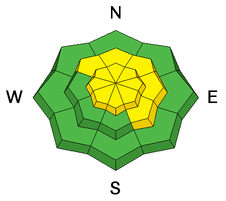
While new wind drifts are today's most obvious and straight-forward avalanche problem, don't get complacent thinking this is the only avalanche dragon out there. The last deep slab avalanche on January 27th near Current Creek Peak, resulted in a close call and a full burial... yeah, it's a great reminder of the sleeping avalanche problem we can't forget. (More info found here ) Deeply triggered slides are elusive, but here's the common theme... steep terrain that faces the north half of the compass, at or above tree line, and particularly slopes that previously avalanched during the big Solstice Storm. Terrain with these characteristics had weak sugary snow develop due to their shallow nature, and January storms added roughly 3-5 feet of stronger snow on top. You know the drill- strong snow on weak snow... no es bueno. Complicating matters is the fact that we can't tell what slopes avalanched back in December because everything has filled back in and they all look the same. My strategy is to assume that all slopes approaching 35 degrees facing the north half of the compass are suspect. The good news is the snowpack is on the mend and I bet it'll gain even more strength the next few days. Practicing a little patience now could have big returns in the near future.
|
 |
weather High pressure strengthens today, resulting in a significant warming trend for the first half of the week. High temperatures reach into the mid 30's with overnight lows in the teens. Northwest winds are gonna be a bit annoying this morning, blowing in the 30's and 40's along the high peaks, but should diminish by about lunch time. Looks like our next chance of snow is about a week out.
|
| general announcements Remember your information can save lives. If you see anything we should know about, please participate in the creation of our own community avalanche advisory by submitting snow and avalanche conditions. You can call me directly at 801-231-2170, email [email protected], or email by clicking HERE If Craig is unavailable you can reach his partner Trent at 801-455-7239, email [email protected] This is a great time of year to schedule a free avalanche awareness presentation for your group or club. You can contact me at 801-231-2170 or email [email protected]. To register for the first in our series of on-the-snow sled specific classes you can register here. The information in this advisory is from the US Forest Service which is solely responsible for its content. This advisory describes general avalanche conditions and local variations always occur. The information in this advisory expires 24 hours after the date and time posted, but will be updated by 7:00 AM on Monday, February 8th.
|