| Please join us at the 23rd annual Black Diamond Fall Fundraiser Party Thursday Sept 15. Tickets are on sale now here, at the Black Diamond store & at REI. Special bonus raffle for online ticket purchasers! |
| Please join us at the 23rd annual Black Diamond Fall Fundraiser Party Thursday Sept 15. Tickets are on sale now here, at the Black Diamond store & at REI. Special bonus raffle for online ticket purchasers! |
| Advisory: Uintas Area Mountains | Issued by Craig Gordon for Sunday - January 17, 2016 - 5:15am |
|---|

|
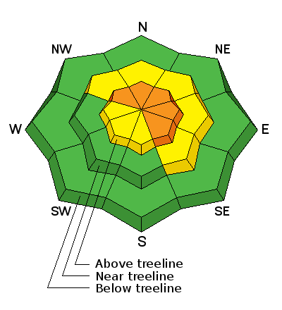
bottom line In the wind zone, above treeline, a CONSIDERABLE avalanche danger exists. Human triggered avalanches are likely on steep, wind drifted slopes, especially those that face the north half of the compass, and particularly on slopes with an easterly component to their aspect . At treeline, in steep, mid elevation terrain, a MODERATE avalanche danger is found and human triggered avalanches are possible on steep slopes with recent deposits of wind drifted snow. Lose the wind and you'll lose the problem. A LOW avalanche danger exists at lower elevations, particularly in wind sheltered terrain.
|
 |
special announcement
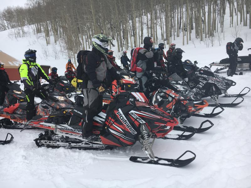
Huge thanks and a big shout out to Park City Powder Cats for hosting yesterday's sled specific Avy 101. I couldn't pull off such a successful class without the help from a truly talented posse of instructors. Thanks to Dan, Phatty, Nick, and Zak from the Boondockers for sharing their riding skills with the group. And Trent, Andy, Tyler, Cody, Jason, and Mark for helping spread the avalanche gospel.... amen! |
 |
current conditions Last nights storm is working its way east and in its wake an evenly distributed 3" of dense, spongy snow fell across the range. Bigger news are the winds. West and southwest winds cranked into the 50's and 60's through the night, reaching a cresendo around 2:00 this morning. They've switched to the west, but are still pretty annoying, blowing 30-40 mph along the high ridges. There's quite a bit of wind damge in our big, open terrain, but lose some elevation or head to the wind sheltered trees and you'll be treated to deep, cold snow.
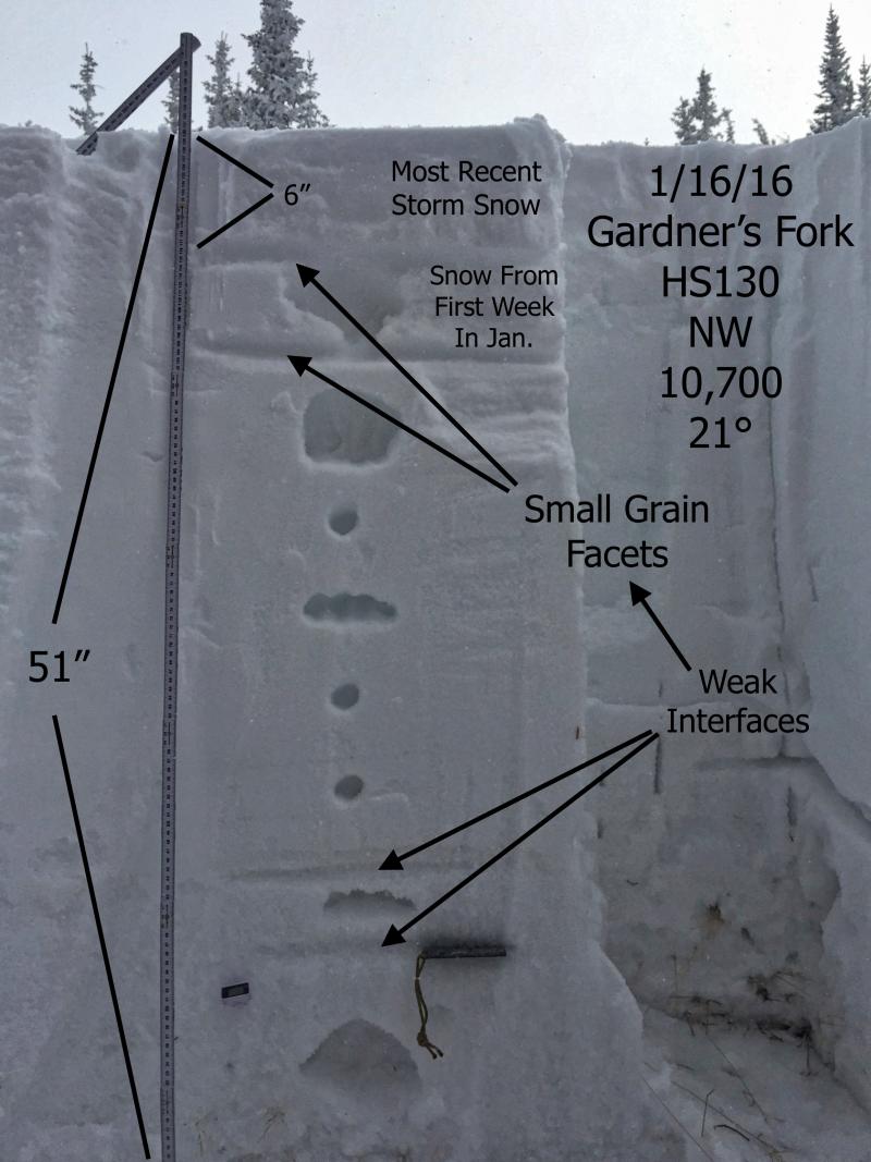
JG does such a killer job with his pit profiles. Here, his pit clearly defines the weak layers we're dealing with at the moment. Most of our instabilities are pretty straight-forward and focus within the new snow/old snow interface. Shears breaking to weak snow near the ground are getting ragged and lack energy, suggesting a turn towards stronger snow. JG's trip report from yesterday is found here. Trip reports and observations are found here.
|
 |
recent activity
Ted was in Gold Hill Basin yesterday and found winds forming sensitive, yet fairly predictable drifts along the leeward side of upper elevation ridges. More on Ted's North Slope travels are found here. Recent avalanche observations are found here. See or trigger an avalanche? Shooting cracks? Hear a collapse? It's simple. Go here to fill out an observation. |
| type | aspect/elevation | characteristics |
|---|

|
|
LIKELIHOOD
 LIKELY
UNLIKELY
SIZE
 LARGE
SMALL
TREND
 INCREASING DANGER
SAME
DECREASING DANGER
|
|
description
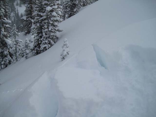
Winds have been blowing for a couple of days and there's no shortage of light density snow available to whip into drifts, sensitive to the additional weight of a rider. I think last nights strong winds coupled with denser snow, created a more connected slab and I bet today's drifts are several feet deep, especially along the leeward side of upper elevation ridges. These won't be deep scary avalanches, but they will be big enough to knock you off your sled, board, or skis and take you for a fast, body brusing ride. Remember- even a small slide can quickly get out of hand if it carries you over a cliff or slams you into a group of trees. The ticket to riding safely today is looking for and avoiding any fat, rounded piece of snow, especially if it sounds hollow like a drum.
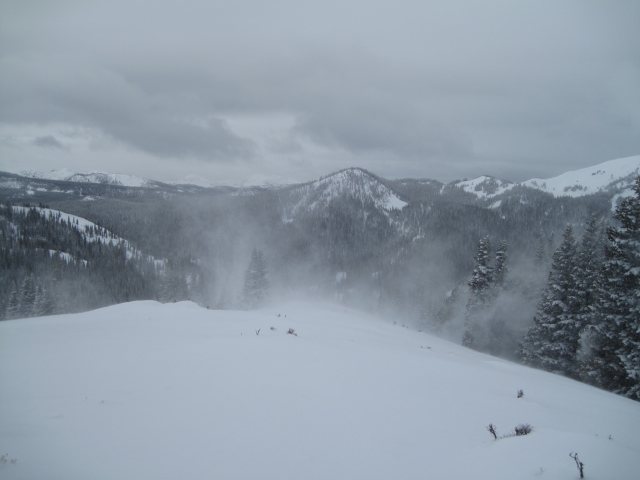
Winds increased along the ridges yesterday and continued to howl overnight. (Scroggin photo)
|
 |
weather Much like Elvis, the storm has taken its final bow, left the stadium, and we're left with strong ridgetop winds through early morning. Along the high ridges, westerly winds blow in the 30's and 40's, gusting into the 50's and 60's. The breezy conditions should mellow somewhat and skies begin to clear by late morning. Temperatures warm into the low 30's with overnight lows in the mid 20's. Another storm is slated to impact the region Monday.
|
| general announcements Remember your information can save lives. If you see anything we should know about, please participate in the creation of our own community avalanche advisory by submitting snow and avalanche conditions. You can call me directly at 801-231-2170, email [email protected], or email by clicking HERE This is a great time of year to schedule a free avalanche awareness presentation for your group or club. You can contact me at 801-231-2170 or email [email protected]. To register for the first in our series of on-the-snow sled specific classes you can register here. The information in this advisory is from the US Forest Service which is solely responsible for its content. This advisory describes general avalanche conditions and local variations always occur. The information in this advisory expires 24 hours after the date and time posted, but be will be updated by 7:00 AM on Monday, January 18th.
|