| Please join us at the 23rd annual Black Diamond Fall Fundraiser Party Thursday Sept 15. Tickets are on sale now here, at the Black Diamond store & at REI. Special bonus raffle for online ticket purchasers! |
| Please join us at the 23rd annual Black Diamond Fall Fundraiser Party Thursday Sept 15. Tickets are on sale now here, at the Black Diamond store & at REI. Special bonus raffle for online ticket purchasers! |
| Advisory: Uintas Area Mountains | Issued by Craig Gordon for Wednesday - January 6, 2016 - 4:18am |
|---|

|
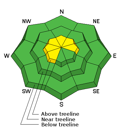
bottom line In the wind zone at and above treeline, a MODERATE avalanche danger exists and human triggered avalanches are possible on steep, wind drifted slopes, especially those that face the north half of the compass. Any slide that breaks to old snow near the ground will be deep and dangerous. Lose the wind and you lose the problem. You'll find a LOW avalanche danger at lower elevations, particularly in wind sheltered terrain and on slopes facing the south half of the compass.
|
 |
current conditions Mostly cloudy skies, a whopping inch of snow in the past 24 hours, and temperatures in the mid teens and low 20's are in store for you this morning. Since Monday, southeast winds have been blowing in the 20's and 30's, but have mellowed out for the moment and are in the 10-20 mph range along the high ridges. The strong winds have jacked most of our big, open terrain and upper elevation bowls. Mid and lower elevation terrain is going to be the ticket today for soft settled powder Trip reports and observations are found here.
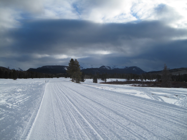
Even Homer would put down the doughnut for this smooth racetrack. Mmmm, fresh roy. (Scroggin photo)
|
 |
recent activity Nothing new to report on this front. Recent avalanche observations are found here. See or trigger an avalanche? Shooting cracks? Hear a collapse? It's simple. Go here to fill out an observation.
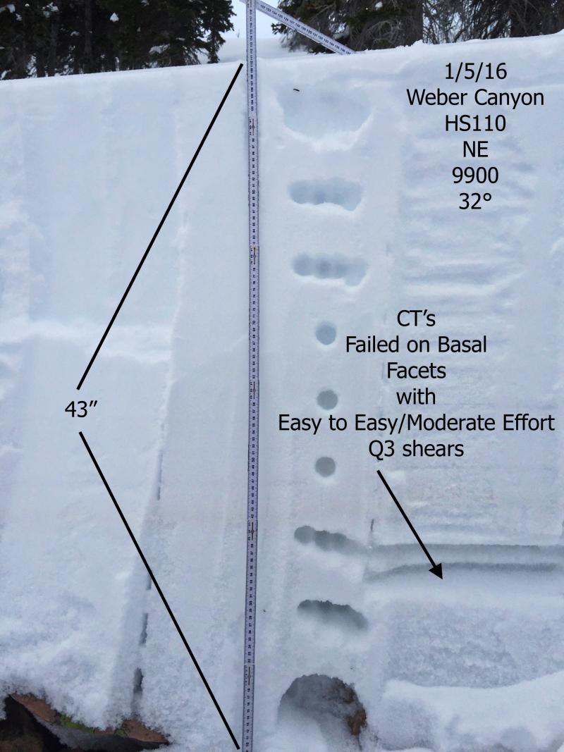
Is this guy awesome or what? JG's detailed and most excellent illustration of snowpack structure in Weber Canyon. (JG Photo) |
| type | aspect/elevation | characteristics |
|---|

|
|
LIKELIHOOD
 LIKELY
UNLIKELY
SIZE
 LARGE
SMALL
TREND
 INCREASING DANGER
SAME
DECREASING DANGER
|
|
description
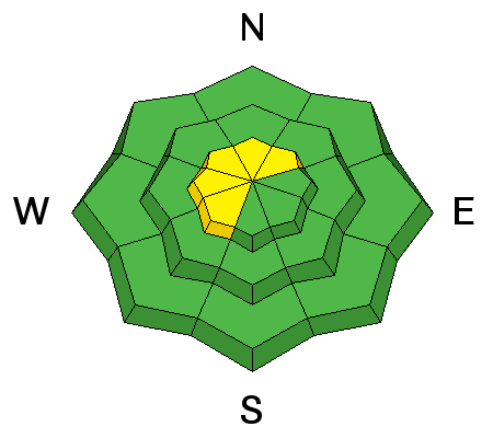
Though there's only an inch of fresh snow to work with, the recent southeast winds formed sensitive, albeit shallow, wind drifts along the leeward side of upper elevation ridges. Due to the easterly component to the recent winds, you'll find fresh slabs in unusual terrain features that face west or cross-loaded in chutes and gullies. While mostly manageable in size and depth and predictably breaking at or below you skis, board, or sled, a manageable drift could get out of hand if it slams you into a group of trees or carries you over a cliff band.
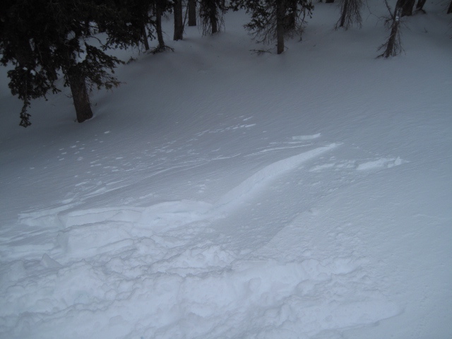
Ted was stomping around Gold Hilll yesterday and found sesitive fresh drifts in wind loaded terrain. (Scroggin photo)
|
| type | aspect/elevation | characteristics |
|---|

|
|
LIKELIHOOD
 LIKELY
UNLIKELY
SIZE
 LARGE
SMALL
TREND
INCREASING DANGER
SAME
DECREASING DANGER
|
|
description
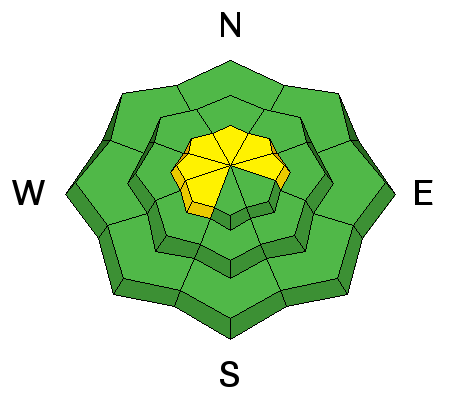
The snowpack seems more comfortable in its own skin and it's been a week since we've heard of any avalanches breaking to old snow near the ground. While this suggests our snowpack is turning the corner towards stability, I'd still continue to carefully evaluate any steep, upper elevation terrain, especially if it faces the north half of the compass, and particularly if it's thin and rocky. Any slide that breaks to old snow is gonna be deep and wide, quickly ruining your day, if not your season.
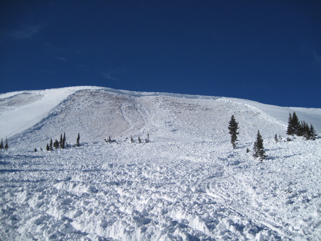
You definitely don't want to be on the receiving end of a deep, dangerous slide like this avalanche, triggered low on the slope the day after Christmas, while a group of sledders were side-hilling. |
 |
weather A weak but moist storm system slides through the region today and tonight giving us a trace to a couple of traces, or is it tri... trey, of snow. It'll be warm with highs reaching into the low 30's and overnight lows dipping into the 20's. Southwest winds remain reasonable and in the 10-20 mph range. Expect unsettled conditions tomorrow with minor snow accumulations possible. Thursday night through Friday night is probably our better shot of measurable snow, but amounts aren't huge, maybe just enough to soften the old snow surface. |
| general announcements Remember your information can save lives. If you see anything we should know about, please participate in the creation of our own community avalanche advisory by submitting snow and avalanche conditions. You can call me directly at 801-231-2170, email [email protected], or email by clicking HERE This is a great time of year to schedule a free avalanche awareness presentation for your group or club. You can contact me at 801-231-2170 or email [email protected]. To register for the first in our series of on-the-snow sled specific classes you can register here. The information in this advisory is from the US Forest Service which is solely responsible for its content. This advisory describes general avalanche conditions and local variations always occur. The information in this advisory expires 24 hours after the date and time posted, but be will be updated by 7:00 AM on Saturday, January 9th by Trent Meisenheimer.
|