| Please join us at the 23rd annual Black Diamond Fall Fundraiser Party Thursday Sept 15. Tickets are on sale now here, at the Black Diamond store & at REI. Special bonus raffle for online ticket purchasers! |
| Please join us at the 23rd annual Black Diamond Fall Fundraiser Party Thursday Sept 15. Tickets are on sale now here, at the Black Diamond store & at REI. Special bonus raffle for online ticket purchasers! |
| Advisory: Uintas Area Mountains | Issued by Trent Meisenheimer for Wednesday - December 30, 2015 - 4:59am |
|---|

|
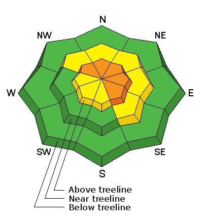
bottom line At and above treeline, a CONSIDERABLE avalanche danger exists and human triggered avalanches are likely on steep, wind drifted slopes, especially those facing the north half of the compass. Any slide that breaks to old snow near the ground will be deep, dangerous, and quite possibly, unsurvivable. Mid elevation terrain offers MODERATE avalanche danger and human triggered avalanches are possible on steep slopes with recent deposits of wind drifted snow. You'll find a LOW avalanche danger at lower elevations, particularly on slopes facing the south half of the compass. Looking for a place to ride today and avoid avalanches altogether? Simply stick to low angle terrain with no steep slopes above or adjacent to where you're riding or choose big, wide open meadows where you can practice carving deep trenches.
|
 |
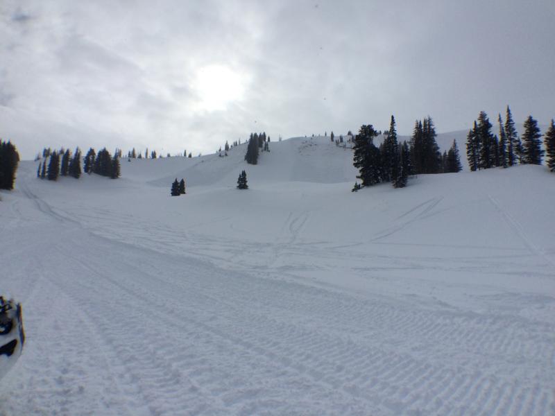
current conditions It's going to be a very cold start with cloudy skies, trailhead temperatures are currently in the low single digits. For the past 24hrs the winds have remained very calm out of the west, blowing 5-15mph even along the high terrain. We have picked up a trace to one inch of new snow overnight. You can still find very nice soft settled powder in many sheltered locations. Trip reports and observations are found here.
Craig Gordon has been hard at work installing beacon checkers at the trail heads this week. Hats off to him for keeping this amazing program rolling and for keeping us on top of the greatest snow instead of buried beneath it. This one at Nobletts trail head. Remember to roll by them and make sure your beacon is sending a signal. If it's a green "circle" like above, you're sending a signal. Red "X" means you're not.
|
 |
recent activity Dave Kikkert - snow safety at the Park City Powder Cats reported three separate sled triggered avalanches yesterday. Each of them were on a northeast aspect around 10,000' in elevation. The avalanches broke to the ground failing on old weak sugary (faceted) snow. They were roughly 2-3' deep 100' wide and could easily bury a person. This tells us that avalanches can still be triggered at or above tree line on the north half of the compass across the Uinta range.
(Photo: Dave Kikkert - recently triggered avalanches in upper Whitney Basin.) Recent avalanche observations are found here. See or trigger an avalanche? Shooting cracks? Hear a collapse? It's simple. Go here to fill out an observation. |
| type | aspect/elevation | characteristics |
|---|

|

|
LIKELIHOOD
 LIKELY
UNLIKELY
SIZE
 LARGE
SMALL
TREND
 INCREASING DANGER
SAME
DECREASING DANGER
|
|
description
I am like anyone else. I look up to different individuals in my life for advice, especially advice about the snowpack. Every mentor - friend - colleague - that I know and trust, continues telling me that the snowpack structure is no good. We have a massive slab (3-6 feet of dense strong snow) sitting on very weak sugary (faceted) snow at the ground, and slopes that face the north half of the compass that are approaching 35 degrees in slope steepness should be avoided. This doesn't mean the season is over for us. In fact this is really good news! This past storm did wonders for us and eventually we can turn the corner to a deep homogenous (even layered snowpack). For now, it's not the time to get after the steep northerly facing terrain, we need to give the snowpack time to breathe and adjust to its new load. The safest option is boondocking in the trees and meadows far away from anything steep. Most of the recent avalanches have been triggered low on the slope from riders carving powder below the hanging steep slopes above. Deep slabs are tricky because we can have many tracks on the slope before it decides to fail. Riding beneath steep shady slopes is like standing below a massive log pile and pulling the bottom log out.... having all the logs fall down on you. (Deep dangerous avalanches can still be triggered - Photo: Ted Scroggin, Double Hill Sunday December 27th)
It's a bit complicated now because you can probably ride plenty of steep slopes and not trigger a slide and think you're good to go. However, the kind of avalanche dragon we're dealing with- DEEP SLABS- often lets you get well out onto the slope before you find a weakness in the pack, collapse the slope, and then BOOM... or in this case WHOOMPH, you're staring down the barrel of a very dangerous slide. Click HERE to view a viddy that pretty much sums up what we're dealing with.
|
 |
weather We will continue to see on and off again snow showers throughout the day as series of weak storms move through the state. West northwest winds will remain light, and well behaved with speeds less than 20mph across the exposed terrain. Temperatures will remain cold today and tonight with highs in the teens and overnight lows dropping to the single digits. On Thursday we will have partly cloudy skies as high pressure builds for Friday.
|
| general announcements Remember your information can save lives. If you see anything we should know about, please participate in the creation of our own community avalanche advisory by submitting snow and avalanche conditions. You can call me directly at 801-231-2170, email [email protected], or email by clicking HERE This is a great time of year to schedule a free avalanche awareness presentation for your group or club. You can contact me at 801-231-2170 or email [email protected]. To register for the first in our series of on-the-snow sled specific classes you can register here. The information in this advisory is from the US Forest Service which is solely responsible for its content. This advisory describes general avalanche conditions and local variations always occur. The information in this advisory expires 24 hours after the date and time posted, but be will be updated by 7:00 AM on Thursday, December 30th by Craig Gordon.
|