| Please join us at the 23rd annual Black Diamond Fall Fundraiser Party Thursday Sept 15. Tickets are on sale now here, at the Black Diamond store & at REI. Special bonus raffle for online ticket purchasers! |
| Please join us at the 23rd annual Black Diamond Fall Fundraiser Party Thursday Sept 15. Tickets are on sale now here, at the Black Diamond store & at REI. Special bonus raffle for online ticket purchasers! |
| Advisory: Uintas Area Mountains | Issued by Craig Gordon for Tuesday - December 29, 2015 - 4:28am |
|---|


|
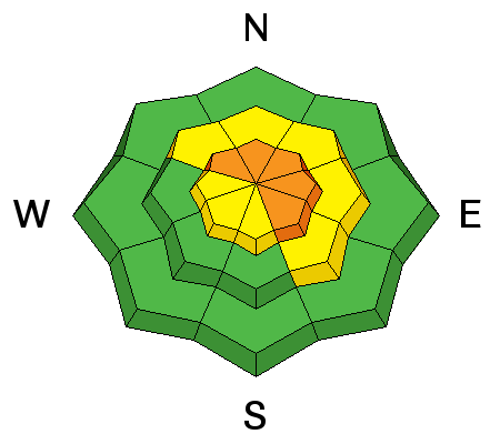
bottom line At and above treeline, a CONSIDERABLE avalanche danger exists and human triggered avalanches are likely on steep, wind drifted slopes, especially those facing the north half of the compass. Any slide that breaks to old snow near the ground will be deep, dangerous, and quite possibly, unsurvivable. Mid elevation terrain offers MODERATE avalanche danger and human triggered avalanches are possible on steep slopes with recent deposits of wind drifted snow. You'll find a LOW avalanche danger at lower elevations, particularly on slopes facing the south half of the compass. Looking for a place to ride today and avoid avalanches altogether? Simply stick to low angle terrain with no steep slopes above or adjacent to where you're riding or choose big, wide open meadows where you can practice carving deep trenches.
|
 |
current conditions Under a blanket of clouds, light snow is falling this morning with just an inch of white paint accumulating overnight. Temperatures are cold and near zero at the trailheads and along the ridges. Winds are light and variable, blowing 5-10 mph even along the high peaks. The Solstice storm snow is settling and it's not quite the wallowfest it was just a few days ago. Excellent riding and turning conditions are found throughout the range. Trip reports and observations are found here.
Now that there's enough snow to stick these signs in, we're getting our trailhead beacon checkers out and about. This one at Nobletts went up yesterday. Remember to roll by them and make sure your beacon is sending a signal. If it's a green "circle" like above, you're sending a signal. Red "X" means you're not.
|
 |
recent activity
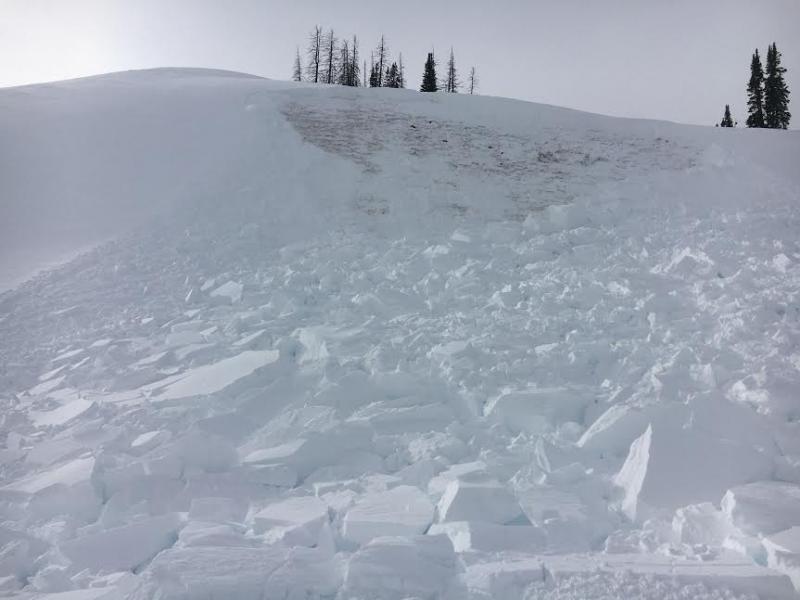
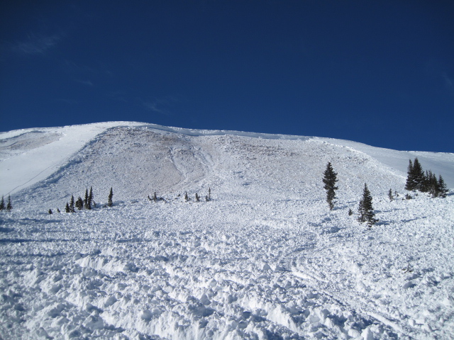
We found this sled triggered pocket on our way to maintain the Currant Creek Weather station. Looks like a rider initiated the slide low on the slope and just like big brother below, the avalanche broke to weak snow near the ground. Not quite a deadly as the Double Hill slide triggered over the weekend, this is a huge red flag none-the-less... steep, wind loaded terrain remains sketchy and still needs to be avoided.
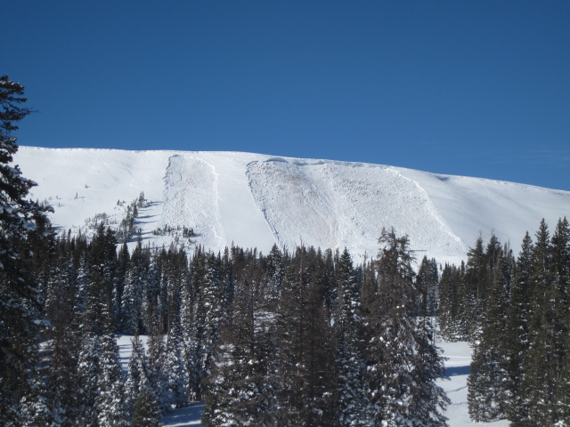
Ted spotted this avalanche on Double Hill in the Whitney Basin on his way to work Sunday. Triggered low on the slope sometime Saturday afternoon, the slide was 7 ft. deep, 200 ft. wide, running 500 ft. vertical. Of course Ted Scroggin knows the Uinta's like no other and his great write-up documenting this close call is found HERE. Recent avalanche observations are found here. See or trigger an avalanche? Shooting cracks? Hear a collapse? It's simple. Go here to fill out an observation. |
| type | aspect/elevation | characteristics |
|---|

|
|
LIKELIHOOD
 LIKELY
UNLIKELY
SIZE
 LARGE
SMALL
TREND
 INCREASING DANGER
SAME
DECREASING DANGER
|
|
description
Not much has changed on this front and the little pocket we discovered in our travels yesterday pretty much confirms the fact that you can still trigger avalanches that break to the ground. While not nearly in the same ballpark as Saturday's deep, dangerous, Double Hill avalanche, we gotta remember that the biggest clue to avalanches is.... well it's avalanches! Duh.... right? Well it's funny (and not in a HA-HA kind of way) how we often don't connect the dots and think, "If we're triggering slides on small slopes, what's gonna happen if I hit the bigger terrain with similar characteristics?" And right now it's a bit complicated because you can probably ride plenty of steep slopes and not trigger a slide and think you're good to go. However, the kind of avalanche dragon we're dealing with- DEEP SLABS- often let you get well out onto the slope before you find a weakness in the pack, collapse the slope, and then BOOM... or in this case WHOOMPH, you're staring down the barrel of a very dangerous slide. Making matters more complicated is you can often trigger a slide of this magnitude from low on the slope, as was the case the past few days. Since there's so many variables with huge consequences if we screw up, the way I deal with this kind of avalanche problem is patience and avoidance. Patience- I know eventually the snowpack is gonna heal, it just needs time. Avoidance- I stay off of and out from under steep wind drifted slopes, especially those that face the north half of the compass, but still have a blast on low angle terrain away from anything steep above or connected to where I'm riding. Done and done! Click HERE to view a viddy that pretty much sums up what we're dealing with.
Down at the arcade... not a very friendly pinball alley. Trees become baseball bats as the avalanche slams us into them going 40 or 50 mph. Remember- trauma smokes 1/4 of us when we get caught in a slide... what a miserable way to exit this earthly existence.
|
 |
weather A couple of weak weather systems brush-by the state through Wednesday, but we'll only pick up a few of inches the next few days. Temperatures remain cold with highs barely reaching into the low teens and overnight lows diving to near zero degrees. Winds remain light, variable, and less than 20 mph along the high ridges. High pressure builds for the latter half of the week producing a slow warming trend with mostly sunny skies in the mountains and valley inversions developing at lower elevations.
|
| general announcements Remember your information can save lives. If you see anything we should know about, please participate in the creation of our own community avalanche advisory by submitting snow and avalanche conditions. You can call me directly at 801-231-2170, email [email protected], or email by clicking HERE This is a great time of year to schedule a free avalanche awareness presentation for your group or club. You can contact me at 801-231-2170 or email [email protected]. To register for the first in our series of on-the-snow sled specific classes you can register here. The information in this advisory is from the US Forest Service which is solely responsible for its content. This advisory describes general avalanche conditions and local variations always occur. The information in this advisory expires 24 hours after the date and time posted, but be will be updated by 7:00 AM on Wednesday, December 30th by Trent Meisenheimer.
|