| Please join us at the 23rd annual Black Diamond Fall Fundraiser Party Thursday Sept 15. Tickets are on sale now here, at the Black Diamond store & at REI. Special bonus raffle for online ticket purchasers! |
| Please join us at the 23rd annual Black Diamond Fall Fundraiser Party Thursday Sept 15. Tickets are on sale now here, at the Black Diamond store & at REI. Special bonus raffle for online ticket purchasers! |
| Advisory: Uintas Area Mountains | Issued by Craig Gordon for Monday - December 28, 2015 - 4:16am |
|---|

|
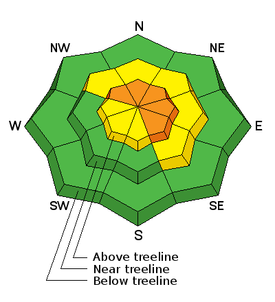
bottom line At and above treeline, a CONSIDERABLE avalanche danger exists and human triggered avalanches are likely on steep, wind drifted slopes, especially those facing the north half of the compass. Any slide that breaks to old snow near the ground will be deep, dangerous, and quite possibly, unsurvivable. Mid elevation terrain offers MODERATE avalanche danger and human triggered avalanches are possible on steep slopes with recent deposits of wind drifted snow. You'll find a LOW avalanche danger at lower elevations, particularly on slopes facing the south half of the compass. Looking for a place to ride today and avoid avalanches altogether? Simply stick to low angle terrain with no steep slopes above or adjacent to where you're riding or choose big, wide open meadows where you can practice carving deep trenches.
|
 |
current conditions High clouds drifted into the area overnight as a weak storm system slated to arrive later tonight, noses into the region. Temperatures are near zero at the trailheads and in the low to mid teens along the ridges. South and southwest winds increased around midnight and are currently blowing 15-25 mph along the high peaks. The Solstice storm snow is settling and it's not quite the wallowfest it was just a few days ago. Excellent riding and turning conditions are found throughout the range. Trip reports and observations are found here.
|
 |
recent activity
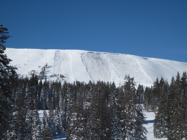
Ted spotted this avalanche on Double Hill in the Whitney Basin on his way to work yesterday. Triggered low on the slope sometime Saturday, the slide was 7 ft. deep, 200 ft. wide, running 500 ft. vertical. Of course Ted Scroggin knows the Uinta's like no other and his great write-up documenting this close call is found HERE. Recent avalanche observations are found here. See or trigger an avalanche? Shooting cracks? Hear a collapse? It's simple. Go here to fill out an observation. |
| type | aspect/elevation | characteristics |
|---|

|
|
LIKELIHOOD
 LIKELY
UNLIKELY
SIZE
 LARGE
SMALL
TREND
 INCREASING DANGER
SAME
DECREASING DANGER
|
|
description
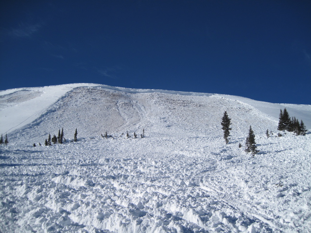
Saturday's deep, dangerous, slide exemplifies the fact that things are still spooky and unpredictable on the eastern front. Remember- last weeks Solstice storm put a huge amount of weight on a fragile, weak snowpack. Sure a lot of steep terrain avalanched naturally throughout the storm cycle, but still many slopes wait for us to come along and knock the legs out from underneath... and here's the tricky part. You can probably ride plenty of steep slopes and not trigger a slide and think you're good to go. However, the kind of avalanche dragon we're dealing with- DEEP SLABS- often let you get well out onto the slope before you find a weakness in the pack, collapse the slope, and then BOOM... or in this case WHOOMPH, you're staring down the barrel of a very dangerous slide. Making matters more complicated is you can often trigger a slide of this magnitude from low on the slope, as was the case in the Double Hill slide. Since there's so many variables with huge consequences if we screw up, the way I deal with this kind of avalanche dragon is patience and avoidance. Patience- I know eventually the snowpack is gonna heal, it just needs time. Avoidance- I stay off of and out from under steep slopes, but still have a blast on low angle terrain away from anything steep above or connected to where I'm riding. Done and done! Click HERE to view a viddy that pretty much sums up what we're dealing with.
Down at the arcade... not a very friendly pinball alley. Trees become baseball bats as the avalanche slams us into them going 40 or 50 mph. Remember- trauma smokes 1/4 of us when we get caught in a slide... what a miserable way to exit this earthly existence.
|
 |
weather Mostly cloudy skies and scattered snow showers are on tap through midweek. Temperatures remain cold the next couple of days with highs in the mid teens and low 20's and overnight lows in the single digits. Southwest winds remain reasonable, in the 10-20 mph range with a few gusts in the 30's along the high peaks. High pressure returns for the New Year.
|
| general announcements Remember your information can save lives. If you see anything we should know about, please participate in the creation of our own community avalanche advisory by submitting snow and avalanche conditions. You can call me directly at 801-231-2170, email [email protected], or email by clicking HERE This is a great time of year to schedule a free avalanche awareness presentation for your group or club. You can contact me at 801-231-2170 or email [email protected]. To register for the first in our series of on-the-snow sled specific classes you can register here. The information in this advisory is from the US Forest Service which is solely responsible for its content. This advisory describes general avalanche conditions and local variations always occur. The information in this advisory expires 24 hours after the date and time posted, but be will be updated by 7:00 AM on Tuesday, December 29th by Trent Meisenheimer.
|