| Please join us at the 23rd annual Black Diamond Fall Fundraiser Party Thursday Sept 15. Tickets are on sale now here, at the Black Diamond store & at REI. Special bonus raffle for online ticket purchasers! |
| Please join us at the 23rd annual Black Diamond Fall Fundraiser Party Thursday Sept 15. Tickets are on sale now here, at the Black Diamond store & at REI. Special bonus raffle for online ticket purchasers! |
| Advisory: Uintas Area Mountains | Issued by Trent Meisenheimer for Thursday - December 24, 2015 - 4:41am |
|---|


|
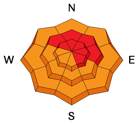
bottom line At mid and upper elevations at and above treeline, a HIGH avalanche danger exists, especially on steep, wind drifted terrain facing the north half of the compass. Both natural and human triggered avalanches are very likely, particularly on slopes with an easterly component to their aspect. Any slide triggered today will be deep, dangerous, and quite possibly, unsurvivable. Backcountry travel in avalanche terrain is not recommended.
|
 |
avalanche warningTHE FOREST SERVICE UTAH AVALANCHE CENTER IN SALT LAKE CITY HAS EXTENDED THE BACKCOUNTRY AVALANCHE WARNING. * TIMING...EXTENDED THROUGH 6 AM MST FRIDAY * AFFECTED AREA...ALL THE MOUNTAINS OF NORTHERN AND CENTRAL UTAH AND SOUTHEASTERN IDAHO TO INCLUDE THE WASATCH RANGE, THE BEAR RIVER RANGE, THE WESTERN UINTAS AND THE MANTI-SKYLINE PLATEAU. OTHER MOUNTAIN RANGES WILL LIKELY BE AFFECTED AS WELL * AVALANCHE DANGER...THE AVALANCHE DANGER FOR THE WARNING AREA IS HIGH * IMPACTS...HEAVY SNOWFALL COMBINED WITH STRONG WINDS HAS CREATED WIDESPREAD AREAS OF UNSTABLE SNOW. HUMAN TRIGGERED AVALANCHES ARE LIKELY AND WILL OCCUR IN MANY AREAS. STAY OFF OF AND OUT FROM UNDER SLOPES STEEPER THAN 30 DEGREES. |
 |
special announcement Very dangerous avalanche conditions exist and slides can be triggered not only on steep wind drifted slopes, but also low on the slope and from adjacent terrain. Once triggered, today's avalanches will break deep and wide, taking out the entire seasons snowpack. This is the exact type of setup that leads to avalanche accidents that always have a sad, devastating ending. |
 |
current conditions The onslaught of storms continued yesterday as a moist northwest flow was over the region. The winds were the big news yesterday blowing 50-60mph out of the west nothwest and damaging much of the powder snow in the high terrain. Thankfully the wind has mellowed out and is currently 15-20mph out of the west southwest. We've picked up 14 inches of new snow in the past 24 hrs. It's going to be a cold start this morning with mountain temperatures hovering in the single digits at the trail heads. Winds will be predominatly out of the west southwest as yet another storm approaches northern utah. Trip reports and observations are found here.
|
 |
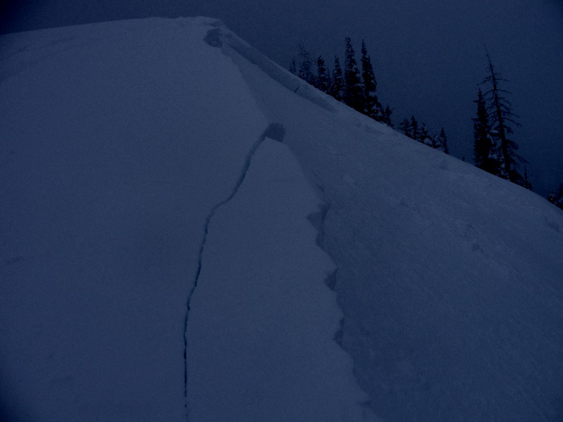
recent activity The snowpack struggles to find itself and hangs in the balance after this week's strong winds and new storm snow. Natural and remotely triggered (from a distance) avalanches were reported from the backcountry yesterday. Reports of large booming collapses and shooting cracks that traveled long distances are still the norm. The writing is on the wall, and all the red flags are there. Picture below is from observer Michael Janulaitis from Hoyt Peak. He triggered this avalanche by simply riding down the safety of the ridge. It demonstrates that avalanches can still be triggered and we are not in the clear just yet.
Recent avalanche activity is not limited to only the Western Uinta mountains. Much of the state of Utah is under and avalanche warning and continues to produce large nature avalanches. Picture below is the valley crasher from the Provo mountains yesterday.
Recent avalanche observations are found here and a viddy recap of last weeks avalanche cycle is found here See or trigger an avalanche? Shooting cracks? Hear a collapse? It's simple. Go here to fill out an observation. |
| type | aspect/elevation | characteristics |
|---|

|
|
LIKELIHOOD
 LIKELY
UNLIKELY
SIZE
 LARGE
SMALL
TREND
 INCREASING DANGER
SAME
DECREASING DANGER
|
|
description
Large and Natural human triggered avalanches continue across the Western Uinta mountains. It's still pretty simple! We have very strong snow on top of very weak snow. Unfortunate this ugly set up isn't going away any time soon. A brief explanation below. Early season snow grew very weak and sugary (faceted) and now we have loaded up the weak snow at the ground with dense, heavy wind driven snow. As a result the sugary faceted snow is no match for the heavy snow on top. To give you an idea of how this works, imagine stacking Champagne glasses on table - then we put a piece of glass over the top of all the Champagne glasses. Next we stack brick by brick on top of the glass. It wont take much time before all the Champagne glasses fail catastrophically. Now, picture this same set up on a 38 degree slope in the backcountry. The Champagne glasses are the weak layer (sugary faceted snow) and the bricks are the heavy new wind driven snow (the slab). All you need to do is add the additional weight of a rider to the slope and the whole mountain will shatter like a paine of glass sending all the bricks down on top of you. Photo - Champagne Glasses (weak layer analogy)
Photo - Actual sugary faceted snow on the ground (champagne glasses)
If you are caught in one of these monsters the best case senerio is you're buried under feet of bone crushing snow. Worst case senario is you're beatened to death by the trauma of this type of avalanche. Fact is.... conditions remain very scary throughout the range. Photo - Consequence of the avalanche (1/4 are killed from trauma) Photo - Size of the avalanches (stacked bricks on champagne glasses)
This doesn't mean you can't ride. What it does mean, is we need to avoid avalanche terrain all together. Simply stick to slopes under 30 deg in slope steepness with no steeper slopes above or adjacent to where you're riding. Simple terrain will allow you success to come back home tonight. Simple means - flat meadows and very low angle trees.
|
 |
weather Yet another winter storm is on its way towards northern Utah. Winds veer to the southwest as the day progresses and increase into the 20's and 30's across the high ridges. Temperatures warm into the mid teens and low twenties. The storm is expected around the midnight hour tonight. Snow amounts tomorrow will be in the 6-12 inch range by late Christmas day. High pressure builds in after Christmas for the weekend.
|
| general announcements Remember your information can save lives. If you see anything we should know about, please participate in the creation of our own community avalanche advisory by submitting snow and avalanche conditions. You can call me directly at 801-231-2170, email [email protected], or email by clicking HERE This is a great time of year to schedule a free avalanche awareness presentation for your group or club. You can contact me at 801-231-2170 or email [email protected]. To register for the first in our series of on-the-snow sled specific classes you can register here. The information in this advisory is from the US Forest Service which is solely responsible for its content. This advisory describes general avalanche conditions and local variations always occur. The information in this advisory expires 24 hours after the date and time posted, but be will be updated by 7:00 AM on Friday, December 25th by Craig Gordon.
|