| Please join us at the 23rd annual Black Diamond Fall Fundraiser Party Thursday Sept 15. Tickets are on sale now here, at the Black Diamond store & at REI. Special bonus raffle for online ticket purchasers! |
| Please join us at the 23rd annual Black Diamond Fall Fundraiser Party Thursday Sept 15. Tickets are on sale now here, at the Black Diamond store & at REI. Special bonus raffle for online ticket purchasers! |
| Advisory: Uintas Area Mountains | Issued by Craig Gordon for Saturday - December 19, 2015 - 5:21am |
|---|

|
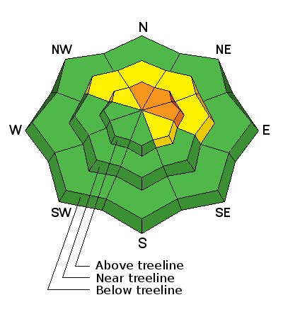
bottom line Dangerous avalanche conditions exist at and above treeline. While not widespread and limited to small portion of the terrain available to ride in, a CONSIDERABLE avalanche danger exists on steep, wind drifted slopes facing the north half of the compass and particularly those with an easterly component to their aspect. Human triggered avalanches are likely on slopes with these characteristics. Any slide triggered today has the potential to break wider and deeper than you might expect, resulting in a dangerous avalanche. You'll find a MODERATE avalanche danger at mid elevations and human triggered avalanches are possible on steep, wind drifted slopes. Low elevations and terrain sheltered from the wind generally offers a LOW avalanche danger.
|
 |
current conditions It's warm and windy this morning with temperatures in the mid to upper 20's. Southerly winds ramped up overnight and they're blowing in the 30's and 40's with gusts to 60 mph along the highest peaks. While our terrain is starting to fill in, the fact is it still remains quite thin. If there's a lump in the snow it's a sled wrecking, base gouging rock... go lightly!
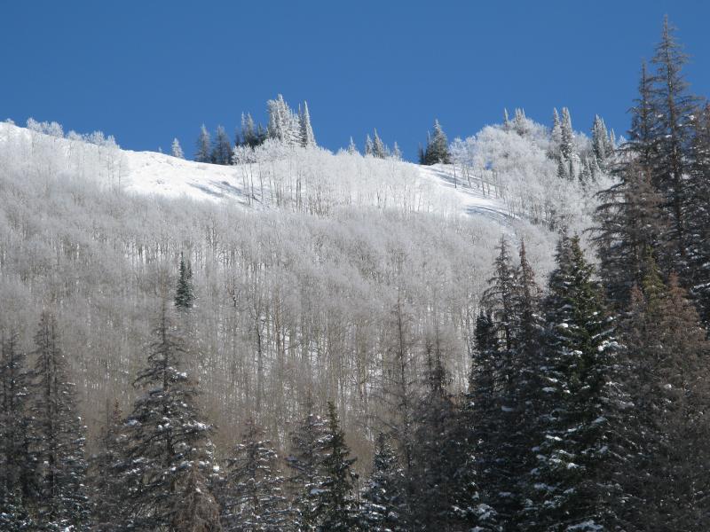
Sure is pretty... unfortunately Thursday nights storm coated the Uinta's with a layer of rime, creating a zipper crust throughout the range. Recent trip reports and observations are found here.
|
 |
recent activity
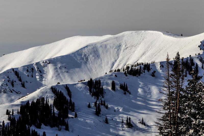
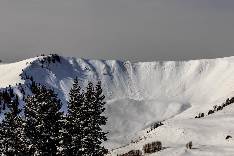
Beautiful avalanche photos above shot by Johnny Adolphson
Wednesday night's raging winds tipped the scales, resulting in numerous avalanches breaking deep, wide, and to the ground. A quick viddy recap is found here Recent avalanche observations are found here. See or trigger an avalanche? Shooting cracks? Hear a collapse? It's simple. Go here to fill out an observation. |
| type | aspect/elevation | characteristics |
|---|

|
|
LIKELIHOOD
 LIKELY
UNLIKELY
SIZE
 LARGE
SMALL
TREND
 INCREASING DANGER
SAME
DECREASING DANGER
|
|
description
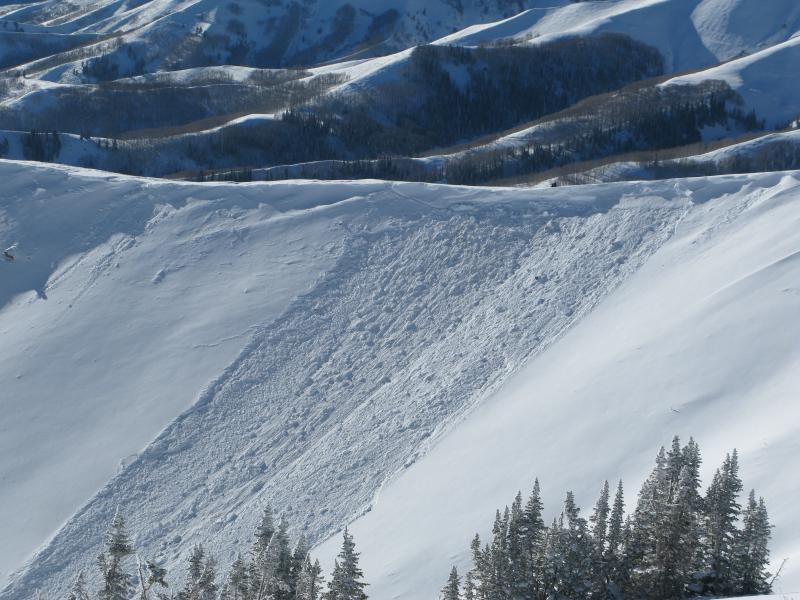
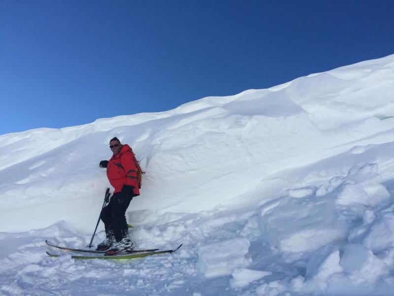
We were out yesterday in upper Weber Canyon taking a look at some of the avalanches that occurred as a result of Wednesday nights nuking winds, and I gotta tell ya, it's not terribly surprising to discover slides breaking to weak snow near the ground. In fact, we were shocked there weren't even more avalanches! What we discovered is... you need just the right combination of windloaded terrain, that has weak snow near the ground, and is steep enough to slide. Sounds simple enough, right? Well the problem is, some slopes have adjusted and gained strength, while others, maybe due to terrain features or a nuance in the snowpack, are just waiting for one of us to come along and knock the legs out from under the slab. The bottom line is- I don't need to be a snow scientist to know this is a spooky setup. No matter how you cut it, once initiated, today's avalanches can easily break to weak snow near the ground resulting in a large, dangerous slide. The most likely place to encounter these conditions is going to be in terrain at or above tree line, especially on shady slopes with an easterly component to their aspect. Remember- any slide that breaks to ground will reveal a nasty array of trauma inducing, season ending obstacles.
Tyler St. Jeor snapped this image of me standing next to one of the recent slides we looked at. Triggering an avalanche today is gonna be a bad deal...
... especially if you got buried in a terrain trap like this gully where debris would stack up very deeply.
|
 |
weather Clouds are drifting into the region ahead of a quick hitting storm that should deliver 4"-6" of snow overnight. In the mean-time, expect southerly winds to ramp up, blowing in the 30's and 40's with gusts in the 70's along the high peaks. Temperatures rise into the mid 30's before dipping into the teens overnight. A break in the action is slated for Sunday and then stormy weather is still on tap for a good portion of next week.
|
| general announcements Remember your information can save lives. If you see anything we should know about, please participate in the creation of our own community avalanche advisory by submitting snow and avalanche conditions. You can call me directly at 801-231-2170, email [email protected], or email by clicking HERE This is a great time of year to schedule a free avalanche awareness presentation for your group or club. You can contact me at 801-231-2170 or email [email protected]. To register for the first in our series of on-the-snow sled specific classes you can register here. The information in this advisory is from the US Forest Service which is solely responsible for its content. This advisory describes general avalanche conditions and local variations always occur. The information in this advisory expires 24 hours after the date and time posted, but be will be updated by 7:00 AM on Sunday, December 20th.
|