| Please join us at the 23rd annual Black Diamond Fall Fundraiser Party Thursday Sept 15. Tickets are on sale now here, at the Black Diamond store & at REI. Special bonus raffle for online ticket purchasers! |
| Please join us at the 23rd annual Black Diamond Fall Fundraiser Party Thursday Sept 15. Tickets are on sale now here, at the Black Diamond store & at REI. Special bonus raffle for online ticket purchasers! |
| Advisory: Uintas Area Mountains | Issued by Craig Gordon for Friday - December 18, 2015 - 4:07am |
|---|

|
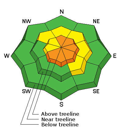
bottom line At and above treeline the avalanche danger is CONSIDERABLE and human triggered avalanches are likely, especially on steep, wind drifted slopes facing the north half of the compass and particularly those with an easterly component to their aspect. Any slide triggered today has the potential to break wider and deeper than you might expect creating a dangerous avalanche. You'll find a MODERATE avalanche danger at mid elevations and human triggered avalanches are possible on steep, wind drifted slopes. Low elevations and terrain sheltered from the wind generally offers a LOW avalanche danger.
|
 |
special announcement Dangerous avalanche conditions exist in the western Uinta's particularly on the North Slope. Large, dangerous, human triggered avalanches are likely today and you should avoid being on or underneath steep wind drifted slopes, especially those facing the north half of the compass. |
 |
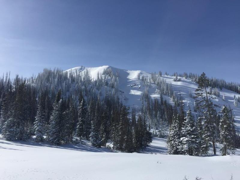
current conditions A dusting of snow fell last night, but skies are beginning to clear as weak high pressure moves into the region. Westerly winds are blowing 15-25 mph along the high peaks and temperatures have warmed into the mid teens and low 20's. The recent round of snow vastly improved riding conditions, but the range still remains quite thin. If there's a lump in the snow it's a sled wrecking, base gouging rock... go lightly! Recent trip reports and observations are found here.
|
 |
recent activity
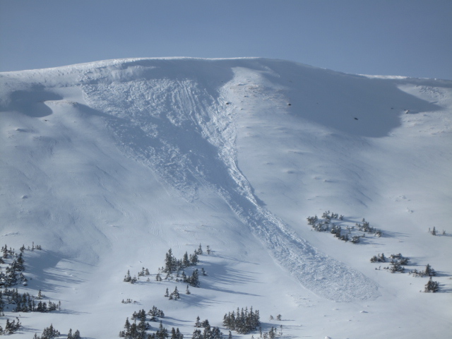
The North Slope went off Wednesday night! Ted found this natural slide on Double Hill yesterday.
Tyler's travels took him to Currant Creek yesterday where the snowpack was less active, but steep wind drifted, upper elevation terrain did experience a "pockety" natural avalanche cycle. In addition numerous large slides were reported in Upper Weber Canyon and Michael J triggered a slide off Hoyt Peak. Recent avalanche observations are found here. See or trigger an avalanche? Shooting cracks? Hear a collapse? It's simple. Go here to fill out an observation. |
| type | aspect/elevation | characteristics |
|---|

|
|
LIKELIHOOD
 LIKELY
UNLIKELY
SIZE
 LARGE
SMALL
TREND
 INCREASING DANGER
SAME
DECREASING DANGER
|
|
description
The range experienced a widespread, natural avalanche cycle Wednesday night when westerly winds ramped up into the 50's and 60's. While much of our steep, upper elevation, wind drifted terrain avalanched naturally, there's still plenty of slopes that remain intact just waiting for a trigger to come along and knock the legs out from under the slab. These are tricky avalanche conditions because you may be able to trigger avalanches from the flats or at a distance, so you'll want to be aware of what kind of terrain is above you and what you're connected to. That fact is... we have strong snow on weak snow and this is a spooky setup. No matter how you cut it, once initiated, today's avalanches can easily break to weak snow near the ground resulting in a large, dangerous slide. The most likely place to encounter these conditions is going to be in terrain at or above tree line, especially on slopes with an easterly component to their aspect. Remember- any slide that breaks to ground will reveal a nasty array of trauma inducing, season ending obstacles.
|
 |
weather A couple of flurries linger over the area early this morning, but in general skies should clear rapidly as the morning progresses, with considerably warmer temperatures this afternoon. High temperatures climb into the mid 30's and southwest winds increase tonight ahead of the next cold front, which should bring another quick round of snowfall Saturday night. Wet, warm, and unsettled weather is slated for next week!
|
| general announcements Remember your information can save lives. If you see anything we should know about, please participate in the creation of our own community avalanche advisory by submitting snow and avalanche conditions. You can call me directly at 801-231-2170, email [email protected], or email by clicking HERE This is a great time of year to schedule a free avalanche awareness presentation for your group or club. You can contact me at 801-231-2170 or email [email protected]. To register for the first in our series of on-the-snow sled specific classes you can register here. The information in this advisory is from the US Forest Service which is solely responsible for its content. This advisory describes general avalanche conditions and local variations always occur. The information in this advisory expires 24 hours after the date and time posted, but be will be updated by 7:00 AM on Saturday, December 19th.
|