| Please join us at the 23rd annual Black Diamond Fall Fundraiser Party Thursday Sept 15. Tickets are on sale now here, at the Black Diamond store & at REI. Special bonus raffle for online ticket purchasers! |
| Please join us at the 23rd annual Black Diamond Fall Fundraiser Party Thursday Sept 15. Tickets are on sale now here, at the Black Diamond store & at REI. Special bonus raffle for online ticket purchasers! |
| Advisory: Uintas Area Mountains | Issued by Craig Gordon for Tuesday - December 15, 2015 - 3:48am |
|---|

|
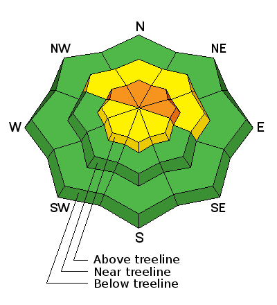
bottom line At and above treeline the avalanche danger is CONSIDERABLE and human triggered avalanches are likely. Any slide triggered today has the potential to break wider and deeper than you might expect creating a dangerous avalanche. A MODERATE avalanche danger is found on steep, wind drifted slopes at mid elevations and human triggered avalanches are possible. Low elevations and terrain sheltered from the wind generally offers a LOW avalanche danger.
|
 |
current conditions A good shot of snow finally developed over the range late Monday and the North Slope is clearly the winner, stacking up 16" of utra-light, cold 'moke. About 1/2 that amount fell the further south you travel through Mirror Lake and Currant Creek. Northwest winds have rollercoastered all night, peaking into the mid 30's around midnight, but in general are pretty well-behaved this morning, averaging 10-20 mph along the high peaks. It's crisp out there this morning with temperatures in the single digits and windchill factors producing a body numbing -15 degrees along the ridges. Sure, the new snow is helping to fill things in, but the fact is, the range is still quite shallow. Road rides or grassy meadows are still your best best to avoid a season ending injury to both yo body and yo sled.
Recent trip reports and observations are found here.
|
 |
recent activity No new avalanches have been reported from the backcountry. See or trigger an avalanche? Shooting cracks? Hear a collapse? It's simple. Go here to fill out an observation. |
| type | aspect/elevation | characteristics |
|---|

|
|
LIKELIHOOD
 LIKELY
UNLIKELY
SIZE
 LARGE
SMALL
TREND
 INCREASING DANGER
SAME
DECREASING DANGER
|
|
description
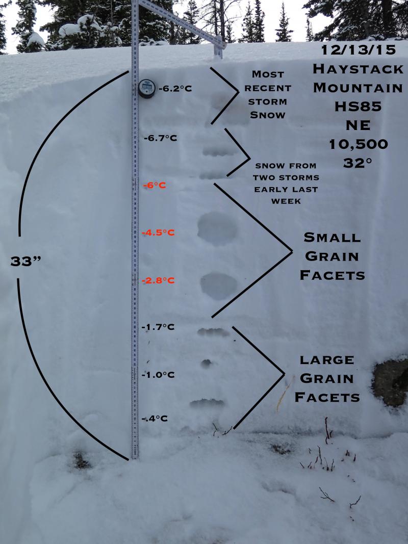
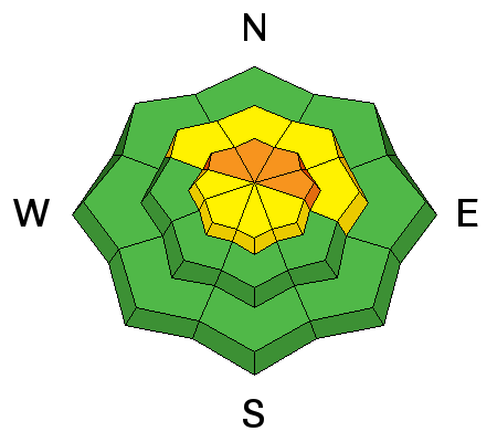
Winds were busy at work the past few days, forming drifts or what we call wind slabs, on the leeward side of upper elevation ridges and around terrain features like chutes and gullies. Unfortunately, the slabs formed earlier in the storm are now covered over with new snow, making them harder to detect and they're resting on a variety of weak layers buried in our snowpack. While predictable in size to begin with, once triggered, a relitively manageable looking slide could quickly get out of hand as it breaks deeper into weak layers buried in the snowpack. The most likely place to encounter these conditions is going to be on slopes facing the north half of the compass at or above tree line. Remember- any slide that breaks to ground is going to reveal a nasty array of season ending obstacles.
JG's most excellent snowpit diagram, clearly illustrates the pre-storm snowpack structure.
|
 |
weather One last gasp of storminess slides through the area this morning, giving us a few more inches of snow, but in general things are winding down. West and northwest winds blow in the 20's and 30's along the high peaks and temperatures only climb into the mid teens before crashing to near zero overnight. A grazing system may bring light additional snow accumulations tomorrow into Thursday, followed by a significant warming trend into the weekend.
|
| general announcements Remember your information can save lives. If you see anything we should know about, please participate in the creation of our own community avalanche advisory by submitting snow and avalanche conditions. You can call me directly at 801-231-2170, email [email protected], or email by clicking HERE This is a great time of year to schedule a free avalanche awareness presentation for your group or club. You can contact me at 801-231-2170 or email [email protected]. To register for the first in our series of on-the-snow sled specific classes you can register here. The information in this advisory is from the US Forest Service which is solely responsible for its content. This advisory describes general avalanche conditions and local variations always occur. The information in this advisory expires 24 hours after the date and time posted, but be will be updated by 7:00 AM on Wedesday, December 16th.
|