| Please join us at the 23rd annual Black Diamond Fall Fundraiser Party Thursday Sept 15. Tickets are on sale now here, at the Black Diamond store & at REI. Special bonus raffle for online ticket purchasers! |
| Please join us at the 23rd annual Black Diamond Fall Fundraiser Party Thursday Sept 15. Tickets are on sale now here, at the Black Diamond store & at REI. Special bonus raffle for online ticket purchasers! |
| Advisory: Skyline Area Mountains | Issued by Brett Kobernik for Saturday - April 9, 2016 - 6:43am |
|---|

|
bottom line The avalanche danger is generally LOW today.
|
 |
special announcement Tomorrow, Sunday, April 10th will be the last regular avalanche advisory for the season. |
 |
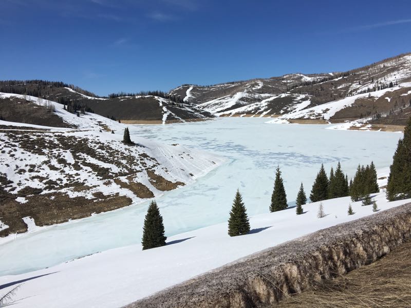
current conditions Well, it sure does feel like spring in the mountains. Most of the terrain has a stout melt-freeze crust from numerous days of heating and cooling at night. The lower and mid elevations have seen substantial melting as has lots of the higher elevation south facing slopes. This is looking at the south facing slopes around Electric Lake: However, there is still decent coverage on the north facing slopes. Looking up Lake Canyon, it still looks like winter:
A minor weather disturbance moved through producing a light snow shower in the hills early Friday evening. Overnight temperatures got down into the low 30s and wind speeds are fairly light. |
 |
recent activity We have not seen any significant avalanche activity for a long time now. I'm not anticipating anything significant this weekend. |
| type | aspect/elevation | characteristics |
|---|

|
|
LIKELIHOOD
 LIKELY
UNLIKELY
SIZE
 LARGE
SMALL
TREND
 INCREASING DANGER
SAME
DECREASING DANGER
|
|
description
Currently the snowpack is quite stable and you can really travel around on most terrain without much concern. It is always good to continue safe backcountry protocol though. It's easy to let our guard down. Pay attention to the snow during the day and move off of steep slopes if the snow becomes really wet and soft. Only put one rider on a slope at a time and make sure you're not stopped in the avalanche runnout zone at the bottom of a slope. |
 |
weather A closed low pressure system over Southern California will move through the southern deserts and push some weather disturbances through our area which might produce a little snow in the higher terrain. It looks like the best chance for snow will be later today and tonight. The storm is going to be warm so any snow will be the heavier type. Today's highs should be in the low to mid 40s. The rain/snow level is going to be pretty high also. Wind will be from the south but won't get real strong. Weather will remain unsettled on Sunday with clouds and possible snow showers. All told, this storm will only produce a few inches of snow at best. |
| general announcements We will publish full detailed advisories Saturday and Sunday mornings by 7am. We will also be publishing basic avalanche danger ratings & info during the week. If you are getting out into the mountains, we love to hear from you! You can SUBMIT OBSERVATIONS ONLINE or EMAIL US If you would like to have avalanche advisories emailed to you, SIGN UP HERE We can provide basic avalanche awareness presentations for your school, group or club. To enquire, CLICK HERE |