| Please join us at the 23rd annual Black Diamond Fall Fundraiser Party Thursday Sept 15. Tickets are on sale now here, at the Black Diamond store & at REI. Special bonus raffle for online ticket purchasers! |
| Please join us at the 23rd annual Black Diamond Fall Fundraiser Party Thursday Sept 15. Tickets are on sale now here, at the Black Diamond store & at REI. Special bonus raffle for online ticket purchasers! |
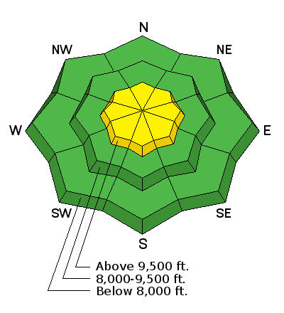
| Advisory: Skyline Area Mountains | Issued by Brett Kobernik for Saturday - March 26, 2016 - 6:28am |
|---|

|
bottom line The majority of the terrain out there has a LOW avalanche danger. The danger may be slightly higher in the upper elevations which received the most snow. Investigate how sensitive the new snow is before getting into steeper terrain. Use caution around cornices since they've grown in size over the last few weeks.
|
 |
current conditions There was a storm that rolled through late Monday and Tuesday which added 4 to 12 inches of snow to the Skyline. There is no doubt that the mid Skyline around Ephraim and Manti Canyons faired better with more snow than the northern area around Fairview Canyon. Temperatures remained fairly cool during the week. We had some stronger wind Thursday into Friday which did scour and drift the snow in the higher terrain. Cornices have grown pretty large. We have a little snow storm in progress right now and, so far, we've picked up 3 to 4 inches of snow overnight. We should see a bit more through mid day today. Temperatures dipped into the teens overnight and the wind is light to moderate in speed from the northwest. |
 |
recent activity No significant avalanche activity was reported this week. Backcountry observations on Thursday and Friday included reports of mostly stable snow. Formal snow stability tests didn't yield any significant results. Click HERE for an observation with some more detailed snow analysis. |
| type | aspect/elevation | characteristics |
|---|

|
|
LIKELIHOOD
 LIKELY
UNLIKELY
SIZE
 LARGE
SMALL
TREND
 INCREASING DANGER
SAME
DECREASING DANGER
|
|
description
Your main focus today will once again be how the newest snow is behaving. This should be a fairly manageable situation for experienced backcountry travelers. Look for any natural avalanche activity that may have occurred in the last 24 hours. Watch for cracking within the new snow. "Sidehill" and or "ski cut" small steep test slopes to see if the new snow breaks away under you. If you can safely get a cornice to fall onto a slope (where no one is below you!), this could give you some good indication on how stable the snow is. My best guess is that the new snow won't increase the avalanche danger much. |
 |
weather We should see a bit more snowfall into mid day today perhaps picking up another few inches. Ridgetop high temperatures will max out around freezing and wind speeds should increase slightly from the north. Sunday looks like a nice day with partly cloudy skies, ridgetop high temperatures around 40 and light southerly wind increasing a bit in speed late in the day. It looks like we'll have another storm that will effect the area early next week with unsettled weather through Thursday. We should see different periods of snow starting Monday lingering into Thursday. It's hard to say how much we'll end up with all said and done but I'm thinking in the 6 to 10 inch range by mid week. |
| general announcements We will publish full detailed advisories Saturday and Sunday mornings by 7am. We will also be publishing basic avalanche danger ratings & info during the week. If you are getting out into the mountains, we love to hear from you! You can SUBMIT OBSERVATIONS ONLINE or EMAIL US If you would like to have avalanche advisories emailed to you, SIGN UP HERE We can provide basic avalanche awareness presentations for your school, group or club. To enquire, CLICK HERE |


