| Please join us at the 23rd annual Black Diamond Fall Fundraiser Party Thursday Sept 15. Tickets are on sale now here, at the Black Diamond store & at REI. Special bonus raffle for online ticket purchasers! |
| Please join us at the 23rd annual Black Diamond Fall Fundraiser Party Thursday Sept 15. Tickets are on sale now here, at the Black Diamond store & at REI. Special bonus raffle for online ticket purchasers! |
| Advisory: Skyline Area Mountains | Issued by Brett Kobernik for Tuesday - February 23, 2016 - 6:53am |
|---|

|
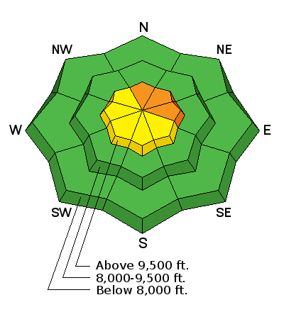
bottom line The 4 to 6 inches of new snow coupled with some stronger wind along the highest terrain has increased the avalanche danger to CONSIDERABLE on specific slopes. Today and Wednesday are the most likely days to trigger an avalanche that breaks to the ground. Areas of concern are north through east facing slopes approaching 40 degrees in steepness which have already avalanched earlier this season and are filled back in. The additional weight of the new wind blown snow will make these slopes more sensitive again. Out of the described terrain the avalanche danger is generally LOW to MODERATE. Slopes under 35 degrees in steepness are also much safer.
|
 |
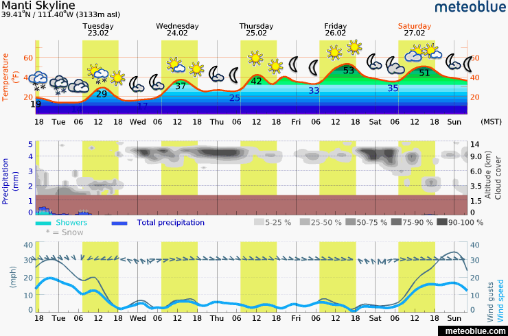
current conditions It looks like the storm on Monday produced the high end of the forecast snow amounts or a bit more than expected. It's looking like we wound up with 4 to 6 inches of snow or perhaps a bit more in the most favored areas. |
 |
weather
|
| general announcements We will publish full detailed advisories Saturday and Sunday mornings by 7am. We will also be publishing basic avalanche danger ratings & info during the week. If you are getting out into the mountains, we love to hear from you! You can SUBMIT OBSERVATIONS ONLINE or EMAIL US If you would like to have avalanche advisories emailed to you, SIGN UP HERE We can provide basic avalanche awareness presentations for your school, group or club. To enquire, CLICK HERE |