| Please join us at the 23rd annual Black Diamond Fall Fundraiser Party Thursday Sept 15. Tickets are on sale now here, at the Black Diamond store & at REI. Special bonus raffle for online ticket purchasers! |
| Please join us at the 23rd annual Black Diamond Fall Fundraiser Party Thursday Sept 15. Tickets are on sale now here, at the Black Diamond store & at REI. Special bonus raffle for online ticket purchasers! |
| Advisory: Skyline Area Mountains | Issued by Brett Kobernik for Monday - January 18, 2016 - 7:04am |
|---|

|
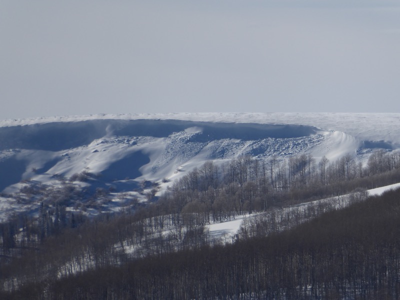
bottom line The majority of the terrain out there has a LOW to MODERATE avalanche danger. The avalanche danger is more pronounced along the upper elevation east facing terrain especially along and just below the ridges. Avoid any obviously large drifts that are on steep slopes. Hill climbing and high marking in the upper elevation east facing steep slopes is the most likely way to trigger an avalanche today.
|
 |
current conditions Wind on Sunday makes the headline today. It picked up and blew from the northwest transporting snow and forming cornices along the higher ridges. It was blowing hard enough to get down into the mid elevations and stir things up as well. It did slow down late in the afternoon. There is still a little breeze and the direction is starting to shift to the southwest. Temperatures are quite mild out there this morning in the upper 20s in the higher terrain. Link to video: Skyline 20160117 from Brett Kobernik on Vimeo. |
 |
recent activity Some of the cornices that were forming on Sunday broke off naturally and triggered small pockets below them also. These in the photo below were the largest ones that I came across. I suspect there may have been some that were bigger.
|
| type | aspect/elevation | characteristics |
|---|

|
|
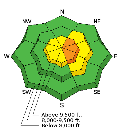
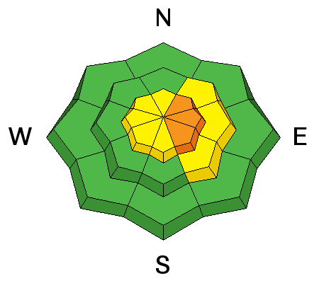
LIKELIHOOD
 LIKELY
UNLIKELY
SIZE
 LARGE
SMALL
TREND
 INCREASING DANGER
SAME
DECREASING DANGER
|
|
description
You will again want to avoid the big east facing steep bowls and watch for cornices and large drifts along the ridges today. The southwest wind will probably transport some more snow today. These fresh drifts will be more stubborn and harder to trigger today but some of them are going to be large enough to be dangerous. These will be more unpredictable than on Sunday as to which ones will release. |
 |
weather We'll have mostly cloudy skies today with mild temperatures and west southwest wind blowing in the moderate speed category. It may be slightly gusty along the upper ridges. A storm will move in later today and snow is possible this afternoon. it looks like most of the snow will fall tonight. It's looking like we'll pick up 3 to 6 inches by Tuesday morning. The long range still looks active but none of the storms look real big. Another one will move through on Wednesday and then another is being advertised for Saturday. |
| general announcements We will publish full detailed advisories Saturday and Sunday mornings by 7am. We will also be publishing basic avalanche danger ratings & info during the week. If you are getting out into the mountains, we love to hear from you! You can SUBMIT OBSERVATIONS ONLINE or EMAIL US If you would like to have avalanche advisories emailed to you, SIGN UP HERE We can provide basic avalanche awareness presentations for your school, group or club. To enquire, CLICK HERE |