| Please join us at the 23rd annual Black Diamond Fall Fundraiser Party Thursday Sept 15. Tickets are on sale now here, at the Black Diamond store & at REI. Special bonus raffle for online ticket purchasers! |
| Please join us at the 23rd annual Black Diamond Fall Fundraiser Party Thursday Sept 15. Tickets are on sale now here, at the Black Diamond store & at REI. Special bonus raffle for online ticket purchasers! |
| Advisory: Skyline Area Mountains | Issued by Brett Kobernik for Sunday - January 17, 2016 - 6:44am |
|---|

|
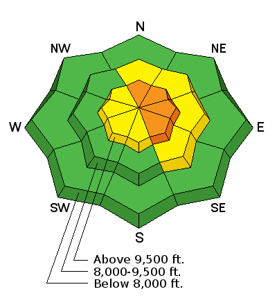
bottom line Away from the higher ridgelines, things are pretty safe out there. A LOW to MODERATE danger exists in most terrain. However, in steep upper elevation terrain where the wind has been blowing snow, human triggered avalanches are likely and a CONSIDERABLE avalanche danger exists. Avoid obvious deep drifts on steep slopes. Watch for cracking as you travel which indicates instability. This danger is most pronounced above 9500 feet on north through east facing slopes.
|
 |
current conditions It looks like the north end of the Skyline picked up about 5 inches of new medium density snow overnight. Stations farther south are not registering much new snow. It does look like the wind picked up for a period overnight with gusts near 40. However, I was expecting worse. Temperatures are in the low 20s. Riding conditions remain excellent. |
| type | aspect/elevation | characteristics |
|---|

|
|
LIKELIHOOD
 LIKELY
UNLIKELY
SIZE
 LARGE
SMALL
TREND
 INCREASING DANGER
SAME
DECREASING DANGER
|
|
description
The wind is the wild card again today. To be honest, I don't really know how dangerous the wind has made things out there. We will have to go out and look for clues to tell us if there are new areas of wind deposited snow that might avalanche. What I'll be looking for today is places where the new snow is obviously deeper than what has fallen over the last few days. This indicates that it has been drifted in. I'll also be looking for any cracking on the snow surface as I travel. I'll be feeling the new snow to see if it feels "upside down" with stiffer snow on the surface and lighter snow underneath. Keep in mind that there was weak snow on the surface prior to the recent storms. We have been able to identify it in snowpits but it hasn't been reactive yet. We have not seen any cracking or avalanche activity on it yet. Areas that have recent deposits of wind drifted snow may be enough to make this layer reactive. Link to video from Saturday: Skyline 20160116 from Brett Kobernik on Vimeo. |
 |
weather Snow showers are still possible this morning but the storm should move out and we should see clearing this afternoon. Westerly wind looks like it will continue to be slightly gusty along the upper ridges. Ridgetop temperatures are going to be in the upper 20s. For Monday, another storm is going to move in late morning and produce snow and wind. The wind continues to look gusty through this next storm. We could see a few inches of accumulation during the day but it looks like the majority will fall Monday night. It looks like 3 to 5" of snow. Temperatures are going to be mild in the upper 20s through this storm. The weather pattern looks active through the long range with numerous storms lined up. |
| general announcements We will publish full detailed advisories Saturday and Sunday mornings by 7am. We will also be publishing basic avalanche danger ratings & info during the week. If you are getting out into the mountains, we love to hear from you! You can SUBMIT OBSERVATIONS ONLINE or EMAIL US If you would like to have avalanche advisories emailed to you, SIGN UP HERE We can provide basic avalanche awareness presentations for your school, group or club. To enquire, CLICK HERE |


