| Please join us at the 23rd annual Black Diamond Fall Fundraiser Party Thursday Sept 15. Tickets are on sale now here, at the Black Diamond store & at REI. Special bonus raffle for online ticket purchasers! |
| Please join us at the 23rd annual Black Diamond Fall Fundraiser Party Thursday Sept 15. Tickets are on sale now here, at the Black Diamond store & at REI. Special bonus raffle for online ticket purchasers! |
| Advisory: Skyline Area Mountains | Issued by Brett Kobernik for Sunday - December 20, 2015 - 6:54am |
|---|

|
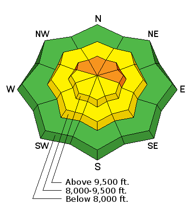
bottom line The avalanche danger remains CONSIDERABLE on the upper elevation terrain that faces northwest through east. Human triggered avalanches are likely in these areas. The easiest way to avoid getting caught is to avoid the steeper northwest through east facing upper elevation terrain until the old weak snow becomes more stable. The danger will increase as the week goes on with additional snowfall expected.
|
 |
current conditions Temperatures along the ridges this morning are still pretty mild with most of the higher stations in the mid 20s. Southwest winds bumped up in speed slightly on Saturday but mainly just along the ridges. The wind did drift a little snow around in the highest terrain. |
 |
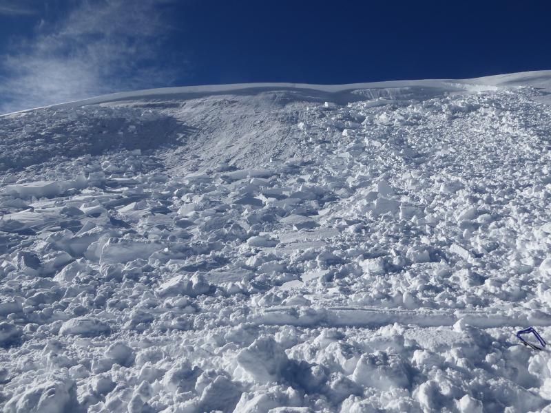
recent activity There was a pretty good size snowmobiler triggered avalanche on Saturday in Jollys Hole in the upper north fork of Manti Canyon. Two riders were playing around the bottom of the slope. The first sidehilled the lower part of the slope without incident. The second went just a bit higher and he triggered the avalanche which broke about 200 feet above him. He was not caught and was able to throttle his sled out of the way before the avalanche caught up to him. Weak old snow from early in the season was the weak layer that failed. The avalanche averaged 4 feet deep but was up to 6 feet in places. This is the exact terrain where we have seen recent natural avalanches. The slope was at around 10,000' and faced east northeast.
|
| type | aspect/elevation | characteristics |
|---|

|
|
LIKELIHOOD
 LIKELY
UNLIKELY
SIZE
 LARGE
SMALL
TREND
 INCREASING DANGER
SAME
DECREASING DANGER
|
|
description
Triggering an avalanche that breaks into old weak sugary snow near the ground is the biggest threat out there today and will continue to be the biggest threat into the week as more storms roll through. Pay attention to any collapsing that might happen as you're traveling today. That is when the snowpack all of a sudden makes a loud "Whumpfing" noise. This is caused by the old weak sugary faceted snow near the ground as it collapses under the weight of the newer snow and you. |
 |
weather We're going to see a quick moving storm roll through this morning which may add an inch of snow or so. Temperatures will remain in the mid 20s along the ridges. Another quick hitting impulse will move through tonight perhaps adding a few more inches. Monday has a chance of snow showers as well. Wind will be from the west and it doesn't look to strong over the next couple of days. A more powerful system will move through Tuesday with stronger westerly wind and a good shot of snow. This system will linger through Wednesday. Things look unsettled through the end of the week. We could see the addition of a couple of feet of snow by the end of the week. |
| general announcements We will publish full detailed advisories Saturday and Sunday mornings by 7am. We will also be publishing basic avalanche danger ratings & info during the week. If you are getting out into the mountains, we love to hear from you! You can SUBMIT OBSERVATIONS ONLINE or EMAIL US If you would like to have avalanche advisories emailed to you, SIGN UP HERE We can provide basic avalanche awareness presentations for your school, group or club. To enquire, CLICK HERE |