25th Annual Black Diamond Fall Fundraising Party
Thursday, September 13; 6:00-10:00 PM; Black Diamond Parking Lot
25th Annual Black Diamond Fall Fundraising Party
Thursday, September 13; 6:00-10:00 PM; Black Diamond Parking Lot
| Advisory: Salt Lake Area Mountains | Issued by Mark Staples for Saturday - April 14, 2018 - 7:43am |
|---|

|
bottom line Since Thursday morning in the Cottonwood Canyons, 12-28 inches of snow has fallen. Because the old snow underneath is hard and frozen, avalanche issues exist only in the new snow. First, watch for wind slabs at the upper elevations where the avalanche danger is MODERATE. Many wind slabs should be well bonded this morning but there are probably some that can still be triggered. Second, as the day warms, the new snow on slopes receiving direct sunshine should become wet and produce some wet loose avalanches. The avalanche danger on these slopes at mid and upper elevations is MODERATE as well. Slopes that do not have wind-blown snow and are not getting wet from warming have a LOW danger. We've been waiting all winter for conditions like these.
|
 |
special announcement The last regular avalanche forecast will be tomorow, Sunday April 15. After that, we will issue intermittent advisories for the Salt Lake mountains through the end of April with each snowfall. We will continue to post all observations so please keep sending those in. |
 |
current conditions Under clear skies this morning temperatures dropped into the teens F. Winds from the NW are blowing 5-10 mph with gusts of 25 mph. Snowfall started Thursday morning and continued through yesterday afternoon. Most places in the Cottonwood Canyons received 12-18 inches of snow (1-1.5 inches of water). Because it benefits from a NW flow, upper Little Cottonwood received 28" of snow (2.14 inches of water). Some lower elevations have about 6 inches of new snow. Read more about the roller-coaster weather this past week in the Week in Review, a recapitulation of the avalanche activity and mountain weather. Thanks for all the support and suggestions for this feature. |
 |
recent activity During strong winds and heavy snowfal on Thursday, soft slabs and sluffs occurred. Two larger slides were reported in the Two Dogs area in Day's Fork that occurred during the storm. One was about a foot deep and maybe 100 feet wide. The other was similar. Ski patrols yesterday in the Cottonwood Canyons triggered a few avalanches with ski cuts and explosives that were barely big enough to bury a person. Also, yesterday, a few different groups reported long running sluffs in the morning in LIttle Cottonwood Canyon. |
| type | aspect/elevation | characteristics |
|---|

|
|
LIKELIHOOD
 LIKELY
UNLIKELY
SIZE
 LARGE
SMALL
TREND
 INCREASING DANGER
SAME
DECREASING DANGER
|
|
description
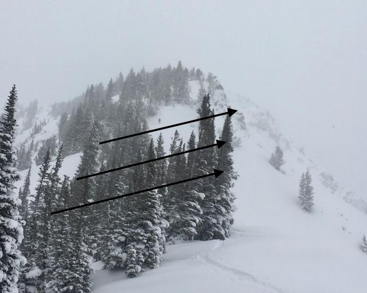
Winds have been blowing from the NW and transporting the new snow. The strongest winds occurred Thursday evening when they were blowing 30-50 mph. Winds at ridgetops continued to transport some snow yesterday. Drew and I went for a quick hike yesterday near Catherine's Pass where these recent drifts and wind slabs seemed like they were bonding to the underlying snow and ice crust. The photo below from that area shows evidence of wind transport where the trees were stripped recent snow. Check out other observations from yesterday here. Regardless of this bonding, some wind slabs could be triggered today. The higher you go in elevation, the more likely it will be that you can find one. The best option is to avoid wind slabs which is doable because you can identify them by their smooth and rounded appearance. Wind slabs can also be identified by their location which is typically under cornices or along cross-loaded gullies. Another higher risk option is to ski cut them before entering a slope.
Heads up - While not an avalanche issue, watch for isolated places where recent winds stripped the new snow off the underlying ice crust. |
| type | aspect/elevation | characteristics |
|---|

|
|
LIKELIHOOD
LIKELY
UNLIKELY
SIZE
LARGE
SMALL
TREND
 INCREASING DANGER
SAME
DECREASING DANGER
|
|
description
Th strong April sun will quickly warm slopes receiving direct sunshine. With a cold start to the day and some clouds expected in the sky, it's hard to know how quickly and how wet the new snow will become by this afternoon. The good news is that this avalanche problem is predictable. When the snow becomes wet, you'll know it because the riding conditions will deteriorate. Additionally, you'll likely see pinwheels and rollerballs of snow tumbling downhill. As this happens the danger of loose wet snow avalanches will increase. The hard ice crust underneath will make it easier for these slides to run far if it becomes wet down to this ice layer. A good strategy this time of year is to slowly change aspects through the day. If starting this morning, begin on slopes receiving direct sun. As the snow on these slopes warms move to shaded or northerly facing slopes which should harbor colder and drier snow. |
 |
weather Today will have a mix of clouds and sunshine. I'm not sure which we'll see more of, but it doesn't take much sunshine this time of year to quickly warm up the air and the snow. High temperatures at 9000 feet should climb into the low 30's F but could feel warmer in the sun. Winds will shift from the NW to W and ease. They will be blowing 5-10 mph and up to 20 mph at the highest elevations. Looking ahead, winds will shift to the SW on Sunday and bring much warmer temperatures. By Sunday evening and Monday morning, winds will increase substantially from the SW. However a cold front will arrive Monday evening and drop temperatures into the teens F. Snowfall should arrive with this cold front and possibly deliver 6-8 inches of snow by late Tuesday. |
| general announcements CLICK HERE FOR MORE GENERAL INFO AND FAQ The UAC has new support programs with Outdoor Research and Darn Tough. Support the UAC through your daily shopping. When you shop at Smith's, or online at Outdoor Research, REI, Backcountry.com, Darn Tough, Patagonia, NRS, Amazon, eBay a portion of your purchase will be donated to the FUAC. See our Donate Page for more details on how you can support the UAC when you shop. Benefit the Utah Avalanche Center when you buy or sell on eBay - set the Utah Avalanche Center as a favorite non-profit in your eBay account here and click on eBay gives when you buy or sell. You can choose to have your seller fees donated to the UAC, which doesn't cost you a penny This information does not apply to developed ski areas or highways where avalanche control is normally done. This advisory is from the U.S.D.A. Forest Service, which is solely responsible for its content. This advisory describes general avalanche conditions and local variations always occur. |