25th Annual Black Diamond Fall Fundraising Party
Thursday, September 13; 6:00-10:00 PM; Black Diamond Parking Lot
25th Annual Black Diamond Fall Fundraising Party
Thursday, September 13; 6:00-10:00 PM; Black Diamond Parking Lot
| Advisory: Salt Lake Area Mountains | Issued by Greg Gagne for Friday - April 13, 2018 - 5:10am |
|---|

|
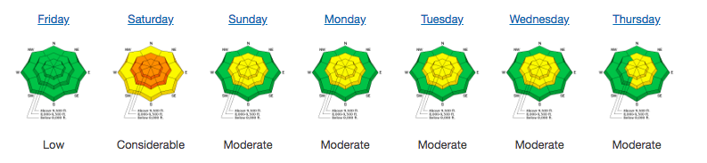
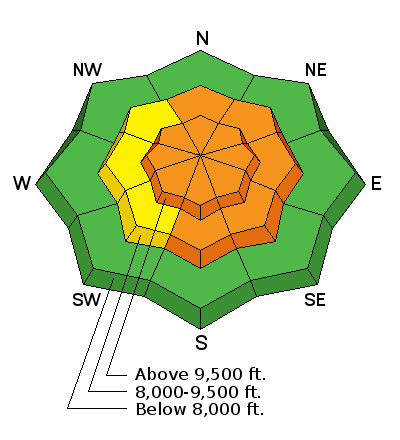
bottom line The avalanche hazard is Considerable today for wind drifts on all aspects at the mid and upper elevations. In areas that received the most snow - such as the upper Cottonwoods - there is a Considerable hazard for loose storm snow and soft slabs at the upper elevations, with a Moderate hazard at the mid elevations as well as areas that received less snow (< 12"). The safest - and best - riding conditions today will be in wind-sheltered terrain at the mid elevations.
|
 |
special announcement The last regular avalanche forecast will be issued on Sunday April 15. After that, we will issue intermittent advisories for the Salt Lake mountains through the end of April as conditions change. We will continue to post all observations so please keep sending those in.
The Wilderness Medicine Program at the University of Utah is surveying the knowledge of both regular and occasional backcountry users. Please provide your input through this survey. https://www.surveymonkey.com/r/AvalancheSafetySkillsSurvey |
 |
current conditions Mountain temperatures range from the upper single digits to mid teens and winds are out of the northwest. Ah, those winds. At 10,500' in upper Little Cottonwood (LCC) winds overnight averaged in the 20's and 30's mph, with gusts in the 40's, peaking at 61 mph. At 11,000' gusts peaked at 75 mph. Dropping 2000' to 8,500' winds were lighter, but still gusts were in the 20's and 30's mph. Under a very unstable, cold northwest flow, snow totals overnight are 11" in LCC and 6" in Big Cottonwood (BCC). Storm totals since Thursday morning are 20" in upper LCC, and 12-16" in BCC. Snowfall overnight in the Park City mountains is 3", with storm totals of 8-12". Every Friday morning we publish our Week in Review, a recapitulation of the avalanche activity and mountain weather from the previous week. Below is the link to our final week in review for this season. Thanks for all the support and suggestions for this feature.
|
 |
recent activity As snowfall began to accumulate later Thursday afternoon, avalanching in loose snow and soft slabs were reported. These were generally small and running within the storm snow, but at least one loose snow avalanche I triggered from a ski cut stepped down to the ice crust that formed this past weekend. Sensitive wind drifts were also reported along upper elevation ridgelines. Below is a quick video clip from the gusty northwest winds along the LCC/BCC ridgeline later Thursday afternoon. |
| type | aspect/elevation | characteristics |
|---|

|

|
LIKELIHOOD
 LIKELY
UNLIKELY
SIZE
 LARGE
SMALL
TREND
 INCREASING DANGER
SAME
DECREASING DANGER
|
|
description
Moderate to strong winds yesterday afternoon and overnight have created fresh wind drifts, and continued winds today - possibly increasing this afternoon - will create additional drifting. You will find fresh drifts from 12-24" on all aspects at the mid and upper elevations, and sensitive cornices will continue to grow. Although ski cuts are a very effective migitation technique with this hazard, deeper drifts are often a bit more stubborn to release. Learn more about wind slabs here. Or check out a nice video by AIARE below. Wind Slab Avalanches from AIARE Avalanche Education on Vimeo. |
| type | aspect/elevation | characteristics |
|---|

|
|
LIKELIHOOD
 LIKELY
UNLIKELY
SIZE
 LARGE
SMALL
TREND
 INCREASING DANGER
SAME
DECREASING DANGER
|
|
description
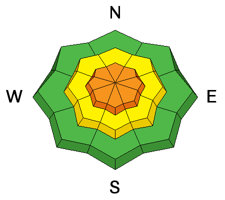
In areas that received the most snow - particularly upper Little Cottonwood - loose storm snow and soft slab avalanches will be possible, especially this morning. Yesterday afternoon I was finding the storm snow sensitive during periods of high precipitation intensity where ski cuts on steeper slopes were running within the storm snow, and sometimes stepping down to the icy crust that formed this past weekend. These slides were running far - up to ~200' - with debris piles 2-3' deep. We've since doubled the storm totals, so any avalanching today in the storm snow will result in deeper, longer-running slides. With only a small amount of snow forecasted for today, I expect storm snow instabilities to settle out as the day progresses. Just as with soft wind drifts, ski cuts are very effective at managing storm snow instabilities. Before dropping into anything steep today I recommend a ski cut at the top of each slope. As always, make sure no one is in the runout zone below and you have an island of safety to move to. |
 |
weather Today will be unsettled with instability showers dropping perhaps 1-3" of snow. Winds will be out of the northwest and remain gusty, blowing in the 20's and 30's mph at the mid and upper elevations, with stronger gusts. Temperatures may reach freezing at 8500', and will be in the mid teens at 10,000'. Clearing overnight with a cool start on Saturday. Increasing temperatures and winds on Sunday and Monday ahead of another vigorous trough out of the Pacific for Tuesday. Models are also advertisting another system for late this coming week, but it may take a more southerly track. The good news is models highlight unsettled conditions through the extended period. I know, I know. Where was this weather in January? |
| general announcements CLICK HERE FOR MORE GENERAL INFO AND FAQ The UAC has new support programs with Outdoor Research and Darn Tough. Support the UAC through your daily shopping. When you shop at Smith's, or online at Outdoor Research, REI, Backcountry.com, Darn Tough, Patagonia, NRS, Amazon, eBay a portion of your purchase will be donated to the FUAC. See our Donate Page for more details on how you can support the UAC when you shop. Benefit the Utah Avalanche Center when you buy or sell on eBay - set the Utah Avalanche Center as a favorite non-profit in your eBay account here and click on eBay gives when you buy or sell. You can choose to have your seller fees donated to the UAC, which doesn't cost you a penny This information does not apply to developed ski areas or highways where avalanche control is normally done. This advisory is from the U.S.D.A. Forest Service, which is solely responsible for its content. This advisory describes general avalanche conditions and local variations always occur. |