25th Annual Black Diamond Fall Fundraising Party
Thursday, September 13; 6:00-10:00 PM; Black Diamond Parking Lot
25th Annual Black Diamond Fall Fundraising Party
Thursday, September 13; 6:00-10:00 PM; Black Diamond Parking Lot
| Advisory: Salt Lake Area Mountains | Issued by Mark Staples for Saturday - March 17, 2018 - 7:15am |
|---|


|
bottom line Today the avalanche danger is CONSIDERABLE at upper elevations. Layers of weak facets lurking in the snowpack 2-5 feet deep can produce large avalanches today. Also, with snow and strong southerly winds, many fresh wind slabs will be found that will be easy to trigger. These wind slabs may be 1-2 feet deep. Safer conditions exist on southerly facing slopes without wind drifted snow. In these places assess bonding and stability within the new snow layers.
|
 |
special announcement Join Mark Staples and Drew Hardesty on Monday, March 19 at 7PM for an interactive discussion of the current Wasatch snowpack. The discussion will occur at RockSteady Bodyworks - 4689 Holladay Blvd Suite E in Holladay. Episode 7 of the UAC Podcast "Mastery and False Mastery - An Interview with 'Big Don' Sharaf" is live. With a snow career spanning 30 years, Don has learned about the profound value of humility and the idea of mastery and if such a thing can exist in the avalanche world. Available at the UAC blog, ITunes, Stitcher, or wherever you get your podcasts. |
 |
current conditions Overnight the upper Cottonwoods received 7 inches of snow while other areas received 4-6 inches with more falling. Temperatures this morning are in the upper teens F at ridgetops and upper 20’s F at many trailhead locations. Winds increased since yesterday and are blowing 10-20 mph gusting 30-50 mph from the S and SW at ridgetops. At lower elevations winds are averaging about 5 mph but gusting 15-30 mph. When assessing avalanche danger, we look at snow water equivalent (SWE) not snow amounts because it tells us how much weight was added to the snowpack. Buried weak layers don’t care how much snow or rain fell, only how much weight was added. More weight = more stress = increased chances of deep slab avalanches. Total water amounts since Wednesday morning are:
|
 |
recent activity A quick review of the last week including notable avalanches can be found HERE. Soft wind slabs were triggered by both backcountry skiers and ski patrols. Many were small; however one much larger one occurred in Cardiff Fork under Cardiac Ridge that was about 200 feet wide. Photo of the Cardiff slide below (M. White).
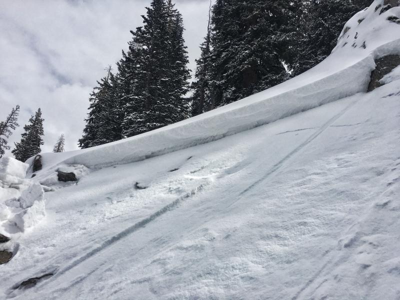
One deep slab was triggered by my partner yesterday on a north facing slope at 10,000 feet. This slide broke on a layer of weak facets just under the dust layer about 2-3 feet deep. While deep, this was a small slide because it was a relatively small slope. It broke in a rocky area which is where facets were weaker and the snowpack was shallower.
|
| type | aspect/elevation | characteristics |
|---|

|
|
LIKELIHOOD
 LIKELY
UNLIKELY
SIZE
 LARGE
SMALL
TREND
 INCREASING DANGER
SAME
DECREASING DANGER
|
|
description
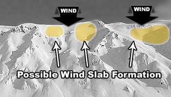
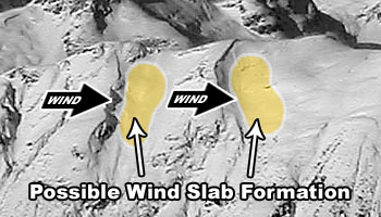
With more snow and strong S and SW winds this morning, expect to see more wind slabs that can be easily triggered today. They should be larger and much more widespread than they were yesterday. Look for fresh deposits of wind-blown snow from top-loading just under ridgetops and from cross loading along gullies. See images below of top and cross loading. Also with more snow falling today, watch for instabilities within the new snow even on slopes without wind-blown snow. Look for cracking in the new snow. Test bonding of the new snow on small slopes where the consequences of triggering an avalanche are small.
|
| type | aspect/elevation | characteristics |
|---|

|
|
LIKELIHOOD
 LIKELY
UNLIKELY
SIZE
 LARGE
SMALL
TREND
 INCREASING DANGER
SAME
DECREASING DANGER
|
|
description
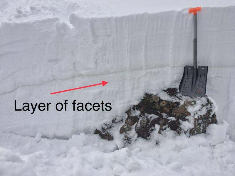
Yesterday, my partner triggered a deep slab avalanche on a small slope. Even though the avalanche broke 2-3 feet deep, it was relatively small because the slope was small. Bigger slopes can produce bigger avalanches (video). Also, it was triggered in a rocky area which is typically a good place to trigger these types of avalanches. Buried rocks make good trigger points, but you don’t always know where they exist. See the rock in my snowpit wall in the photo below as a good example. Here’s what we know about this avalanche problem
|
 |
weather A cold front in Nevada this morning is approaching northern Utah. It should bring an additional 5-9 inches of snow which should fall mostly this morning. Light snow showers should continue through the afternoon. Strong south winds will continue until his front passes, and they should start to diminish this afternoon. Temperatures shouldn’t change much from where they are this morning. They may warm a bit at lower elevations with normal daytime warming but could drop some at higher elevations once the cold front arrives. |
| general announcements CLICK HERE FOR MORE GENERAL INFO AND FAQ The UAC has new support programs with Outdoor Research and Darn Tough. Support the UAC through your daily shopping. When you shop at Smith's, or online at Outdoor Research, REI, Backcountry.com, Darn Tough, Patagonia, NRS, Amazon, eBay a portion of your purchase will be donated to the FUAC. See our Donate Page for more details on how you can support the UAC when you shop. Benefit the Utah Avalanche Center when you buy or sell on eBay - set the Utah Avalanche Center as a favorite non-profit in your eBay account here and click on eBay gives when you buy or sell. You can choose to have your seller fees donated to the UAC, which doesn't cost you a penny This information does not apply to developed ski areas or highways where avalanche control is normally done. This advisory is from the U.S.D.A. Forest Service, which is solely responsible for its content. This advisory describes general avalanche conditions and local variations always occur. |