25th Annual Black Diamond Fall Fundraising Party
Thursday, September 13; 6:00-10:00 PM; Black Diamond Parking Lot
25th Annual Black Diamond Fall Fundraising Party
Thursday, September 13; 6:00-10:00 PM; Black Diamond Parking Lot
| Advisory: Salt Lake Area Mountains | Issued by Greg Gagne for Friday - March 2, 2018 - 4:56am |
|---|

|
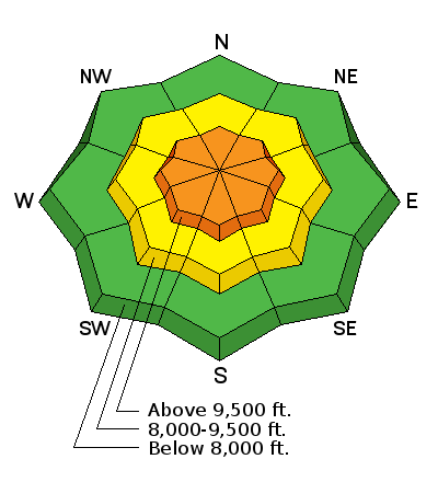
bottom line The Utah Avalanche Center has issued an avalanche watch for dangerous avalanche conditions developing later today and into this weekend. The avalanche danger is CONSIDERABLE at the upper elevations, and MODERATE at the mid elevations, for fresh wind drifts. These drifts can be found on all aspects. Deeper slides can be triggered on isolated slopes facing west through north through southeast, especially on slopes with a thinner snowpack. Strong winds today and into Saturday, and a forecasted cold front with heavy snow arriving Saturday afternoon, means this weekend will have a rising avalanche hazard. Follow utahavalanchecenter.org for the latest updates
|
 |
avalanche watch THE FOREST SERVICE UTAH AVALANCHE CENTER IN SALT LAKE CITY HAS ISSUED A BACKCOUNTRY AVALANCHE WATCH. * TIMING…IN EFFECT FROM 6 AM MST THIS MORNING TO 6 AM MST SATURDAY * AFFECTED AREA…FOR THE MOUNTAINS OF NORTHERN AND CENTRAL UTAH INCLUDING THE WASATCH RANGE...BEAR RIVER RANGE...UINTA MOUNTAINS...AND THE MANTI-SKYLINE AND WASATCH PLATEAU. * AVALANCHE DANGER…THE AVALANCHE DANGER FOR THE WARNING AREA IS CONSIDERABLE AND IS EXPECTED TO RISE TO HIGH BY SATURDAY. * IMPACTS…STRONG WINDS AND HEAVY SNOWFALL WILL LIKELY CREATE DANGEROUS AVALANCHE CONDITIONS BY LATER TODAY, AND CONTINUING INTO MONDAY. BOTH HUMAN TRIGGERED AND NATURAL AVALANCHES ARE LIKELY. STAY OFF OF AND OUT FROM UNDER SLOPES STEEPER THAN 30 DEGREES. BACKCOUNTRY TRAVELERS SHOULD CONSULT WWW.UTAHAVALANCHECENTER.ORG OR CALL 1-888-999-4019 FOR MORE DETAILED INFORMATION. THIS WARNING DOES NOT APPLY TO SKI AREAS WHERE AVALANCHE HAZARD REDUCTION MEASURES ARE PERFORMED. |
 |
special announcement I'm especially excited about this one! The latest edition of the UAC podcast is live - "A Conversation with Tom Kimbrough. Hemingway of the Wasatch". Tom is a retired climbing ranger in Grand Teton National Park, and a longtime avalanche forecaster with the UAC. A role model and mentor to many of us. Sit back and enjoy listening to Drew having a conversation with Tom! Spend some time improving your rescue skills or learning about avalanches in this upcoming Salt Lake City area class:
|
 |
current conditions Skies are generally clear and mountain temperatures are in the 20's F. Early risers will be greeted by a beautiful Sap moon setting in the western sky. 1-3" of snow fell Thursday afternoon, but good luck finding it as winds are the dominant story today. Strong winds out of the south are gusting into the 40's through the 60's, peaking at 86 mph at 11,000'. Winds are even working into the lower elevations with gusts in the 20's. Be sure to read the Week in Review summarizing mountain weather and avalanche activity for the past week.
February snow and water numbers from Alta Guard (8700') are in: 66" of snow with 5.45" of water. This is 81% and 76% of average. Not sure about you, but I thought February was pretty good. A nice reminder that, even in lean years, the Wasatch remains the envy of many others. |
 |
recent activity Moderate to strong southwesterly winds on Thursday created pockets of sensitive soft wind drifts at the mid and upper elevations. These were 2-8" thick, but not breaking out very widely. |
| type | aspect/elevation | characteristics |
|---|

|
|
LIKELIHOOD
 LIKELY
UNLIKELY
SIZE
 LARGE
SMALL
TREND
 INCREASING DANGER
SAME
DECREASING DANGER
|
|
description
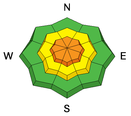
Strong winds overnight and into today will find any soft snow, and will transport it creating fresh wind drifts. Although I am expecting these drifts to be scattered, you will find fresh wind slabs on all aspects at all elevations. Cornices are becoming more widespread along ridgelines – continuing to grow with today’s increasing southerly winds. Cornices often break back further than expected, on to what often looks like flat terrain. Give them a wide berth and avoid travel below them. |
| type | aspect/elevation | characteristics |
|---|

|
|
LIKELIHOOD
 LIKELY
UNLIKELY
SIZE
LARGE
SMALL
TREND
INCREASING DANGER
SAME
DECREASING DANGER
|
|
description
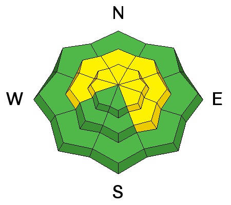
Avalanches breaking into old snow have been reported this past week. This includes layers of faceted snow at the mid-pack, as well as down near the ground. This terrain can be found above 9000' on aspects facing west through southeast. The photo below is a persistent slab avalanche earlier this week in Main Days Fork on a slope that has avalanched at least a few times this season. [Erme Catino photo]. Slopes that are most suspect include thinner snowpack areas outside of the upper Cottonwoods, as well as slopes that have already slid this season. Although we are not expecting the bulk of the snowfall with this upcoming storm to begin falling until Saturday, drifts from the strong pre-frontal winds will add stress to these weak layers.
|
 |
weather Although our friends at the Mount Washington Avalanche Center in NH might call this a gentle spring breeze, wind is the name of the game over - at least - the next 24-36 hours, and it will be a struggle to find sheltered terrain. Winds are forecasted to average in the 20's at 9000', and in the 30's mph at 10,000'. Gusts will reach the 50's at mid elevations, and into the 60's and 70's (perhaps stronger) at the upper elevations. Temperatures will range through the 20's and low 30's F. Increasing clouds with snow showers possible this afternoon. Timing for this storm continues to get pushed back, and we are now expecting serious snowfall to begin later Saturday afternoon. We are still on track for a significant storm with upwards of one to two feet of snow at the higher elevations. |
| general announcements CLICK HERE FOR MORE GENERAL INFO AND FAQ The UAC has new support programs with Outdoor Research and Darn Tough. Support the UAC through your daily shopping. When you shop at Smith's, or online at Outdoor Research, REI, Backcountry.com, Darn Tough, Patagonia, NRS, Amazon, eBay a portion of your purchase will be donated to the FUAC. See our Donate Page for more details on how you can support the UAC when you shop. Benefit the Utah Avalanche Center when you buy or sell on eBay - set the Utah Avalanche Center as a favorite non-profit in your eBay account here and click on eBay gives when you buy or sell. You can choose to have your seller fees donated to the UAC, which doesn't cost you a penny This information does not apply to developed ski areas or highways where avalanche control is normally done. This advisory is from the U.S.D.A. Forest Service, which is solely responsible for its content. This advisory describes general avalanche conditions and local variations always occur. |


