25th Annual Black Diamond Fall Fundraising Party
Thursday, September 13; 6:00-10:00 PM; Black Diamond Parking Lot
25th Annual Black Diamond Fall Fundraising Party
Thursday, September 13; 6:00-10:00 PM; Black Diamond Parking Lot
| Advisory: Salt Lake Area Mountains | Issued by Evelyn Lees for Sunday - February 25, 2018 - 6:13am |
|---|

|
bottom line The avalanche danger is CONSIDERABLE on all steep, upper elevation slopes, especially those with recent wind drifts, and on many steep mid elevation slopes. Other steep slopes have a MODERATE danger. Complex and dangerous avalanche conditions exist – cautious route finding, careful snow pack evaluation and conservative decision making essential. You will find better and safer skiing and riding conditions on the numerous lower-angled wind sheltered slopes. But be aware of what's above you and avoid travel below steep slopes.
|
 |
special announcement Avalanche mitigation work will be done in Upper McDonalds Draw today – the area is closed to backcountry touring. We have discount lift tickets for Alta, Snowbird, Brighton, Solitude, Snowbasin, and Beaver Mountain. Details and order information here. All proceeds from these go towards paying for avalanche forecasting and education! |
 |
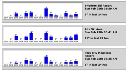
current conditions The fast moving storm is on its way out, after dropping a quick 9” in upper LCC, containing a ½” of water. 3 to 6” of snow fell in Big Cottonwood and on the Park City side. This wind blown low-density snow is capping off a week of steady snowfall.
While temperatures are actually above zero this morning, double digits readings are scarce, only to be found at the lowest elevations. Winds have varied from the southwest to northwest during the past 24 hours, reaching significant speeds at times of 15 to 20 mph averages at the mid elevations, with 25 -35 mph averages across the exposed higher peaks. |
 |
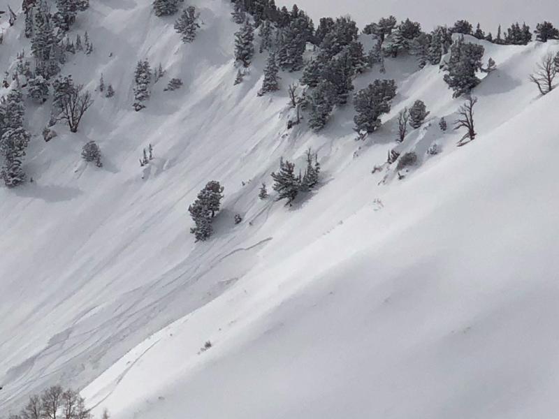
recent activity Yesterday’s most interesting avalanche was triggered at 9700’ on east facing Raymond Peak, failing on a very thin mid-pack layer of facets sandwiched in between 2 crusts. In addition, numerous small to medium size new snow avalanches and wind drifts were easily triggered. Photos of east facing Raymond slide - Gagne left, Hardesty right.
|
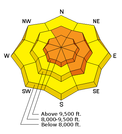
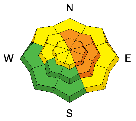
| type | aspect/elevation | characteristics |
|---|

|
|
LIKELIHOOD
 LIKELY
UNLIKELY
SIZE
 LARGE
SMALL
TREND
 INCREASING DANGER
SAME
DECREASING DANGER
|
|
description
Periods of significant winds the past 24 hours have built drifts onto a variety of aspects, most failing on the low-density snow as a weak layer. While the newest wind drifts will be easy to identify – rounded, smooth pillows of snow - yesterday’s wind slabs are now hidden under the new snow. Cracking of denser snow is sometimes an indication that you have hit a wind slab. Cornices have continued to grow along the mid and upper elevation ridge lines. They often break back further than expected, so give them a wide berth and avoid travel below them. |
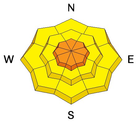
| type | aspect/elevation | characteristics |
|---|

|
|
LIKELIHOOD
 LIKELY
UNLIKELY
SIZE
 LARGE
SMALL
TREND
INCREASING DANGER
SAME
DECREASING DANGER
|
|
description
On some slopes, the faceted layers in our snowpack may have reached a breaking point. These deeper slides could be 2 to 3 feet deep, and are most likely to break on a mid-pack faceted weak layer, which exist on many aspects. Any smaller triggered slide – such as a wind slabs or sluff – has the potential to step down to one of these deeper weak layers. In the shallow snowpack areas, slides may break on the faceted snow nearer to the ground – for example, steep slopes at the mid elevations, slopes that have slid one or more times this year, and terrain with a shallower snowpack such as Millcreek, part of the Park City ridge line and lower in the Cottonwood Canyons. Cracking and collapsing are bulls-eye clues to instability, but these clues may not be present, and snow pit tests are proving to be unreliable. If you didn’t catch it yesterday, here’s Trent’s video from 8,000' on a north facing slope in Broads Fork highlighting the shallow snowpack issue. And Drew and Zinnia's video of the Raymond slide - a sneaky mid pack faceted weak layer. |
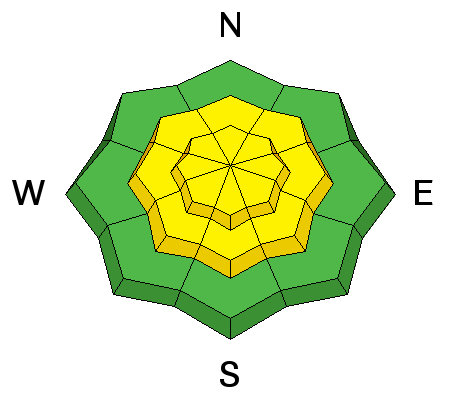
| type | aspect/elevation | characteristics |
|---|

|
|
LIKELIHOOD
LIKELY
UNLIKELY
SIZE
LARGE
SMALL
TREND
 INCREASING DANGER
SAME
DECREASING DANGER
|
|
description
Storm snow soft slabs and loose snow sluffs can be triggered today on many steep slopes. |
 |
weather This morning’s snow should taper off by around noon, with skies partially clearing. Temperatures will warm into the teens and low 20s. The westerly winds will remain brisk and gusty – at times averaging 25 mph averages at the mid elevations and 30 mph at the upper elevations. Increasing clouds and southwesterly winds tonight, with temperatures in the teens. Another small storm Monday night into Tuesday. |
| general announcements CLICK HERE FOR MORE GENERAL INFO AND FAQ The UAC has new support programs with Outdoor Research and Darn Tough. Support the UAC through your daily shopping. When you shop at Smith's, or online at Outdoor Research, REI, Backcountry.com, Darn Tough, Patagonia, NRS, Amazon, eBay a portion of your purchase will be donated to the FUAC. See our Donate Page for more details on how you can support the UAC when you shop. Benefit the Utah Avalanche Center when you buy or sell on eBay - set the Utah Avalanche Center as a favorite non-profit in your eBay account here and click on eBay gives when you buy or sell. You can choose to have your seller fees donated to the UAC, which doesn't cost you a penny This information does not apply to developed ski areas or highways where avalanche control is normally done. This advisory is from the U.S.D.A. Forest Service, which is solely responsible for its content. This advisory describes general avalanche conditions and local variations always occur. |