25th Annual Black Diamond Fall Fundraising Party
Thursday, September 13; 6:00-10:00 PM; Black Diamond Parking Lot
25th Annual Black Diamond Fall Fundraising Party
Thursday, September 13; 6:00-10:00 PM; Black Diamond Parking Lot
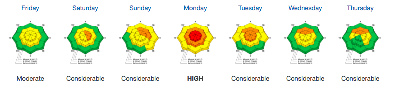
| Advisory: Salt Lake Area Mountains | Issued by Evelyn Lees for Saturday - February 24, 2018 - 6:37am |
|---|

|
bottom line It is a day of increasing avalanche danger. The avalanche danger is MODERATE this morning on all steep, wind-drifted slopes. A MODERATE hazard also exists for triggering a 1 to 3 foot deep avalanche in isolated terrain on steep slopes facing west through north through southeast at the mid and upper elevations, where a slide could fail in the older faceted snow. Evaluate snow and terrain carefully. The avalanche danger will rise to CONSIDERABLE late this afternoon or overnight with stronger winds and more snow in the forecast. The Good News: excellent and safer skiing and riding conditions can be found on lower-angled wind sheltered slopes of all aspects. Storms the past few weeks have finally provided many excellent options at the mid elevations for the first time this season.
|
 |
special announcement The free Solitude beacon park is now up and running – it’s at the far west end of the lower parking lot. We have discount lift tickets for Alta, Snowbird, Brighton, Solitude, Snowbasin, and Beaver Mountain. Details and order information here. All proceeds from these go towards paying for avalanche forecasting and education! |
 |
current conditions What a week it’s been - an all you can eat powder buffet, and free refills on the way. The Salt Lake and Park City area mountains have received 1 ½ to 2 feet of snow this week, topped off Thursday and Friday with another 6 to 9” in the Cottonwoods and 2 to 4” on the Park City side. The Ogden area mountains have received over 2 feet of snow in places, and the Provo area mountains over a foot. Cold temperatures and clouds have preserved the powder on all aspects. You may catch a glimpse of sun this morning before skies cloud up again ahead of tonight’s storm. Temperatures are back down below zero at most stations this morning, and will struggle to crawl into the single digits and teens today. The westerly winds are stronger than I would like - the 9 and 10,000’ ridge lines have 15 to 20 mph averages, and at 11,000’, speeds are averaging 35 mph, with gusts in the 40s. Be sure to check our Week in Review as you make your weekend plans:
|
 |
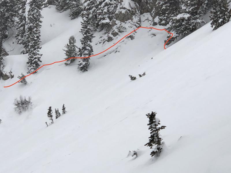
recent activity The only avalanche activity reported yesterday were small soft wind slabs, mostly confined to the upper elevations, and sluffing of the new snow. A recent large cornice fall was noted along the Park City ridge line The storm system this past Monday produced quite a few natural avalanches and a few human triggered slides that failed in older, faceted snow. Details on these slides can be found HERE. Examples include smaller slides on northeast aspects at 9700', photo on the left, with a starting zone in thin, rocky terrain and a deeper, wider slide in Mill Creek, on the right.
|
| type | aspect/elevation | characteristics |
|---|

|
|
LIKELIHOOD
 LIKELY
UNLIKELY
SIZE
 LARGE
SMALL
TREND
 INCREASING DANGER
SAME
DECREASING DANGER
|
|
description
The winds are a bit of a spoiler today – wind speeds are strong enough to drift the low-density snow and expected to continue at the current speeds. The new wind drifts or wind slabs will cracky and easy to trigger, forming along the mid and higher elevation ridge lines. Avoid any steep slopes with wind drifts, and be aware that the drifts will become more widespread and deeper as the day progresses. Cornices will also be forming along the mid and upper elevation ridge lines. They often break back further than expected, so give them a wide berth and avoid travel below them. |
| type | aspect/elevation | characteristics |
|---|

|

|
LIKELIHOOD
 LIKELY
UNLIKELY
SIZE
 LARGE
SMALL
TREND
INCREASING DANGER
SAME
DECREASING DANGER
|
|
description
As we continue to add more snow, including wind drifts, onto steep slopes, we could overload the some of the weak facet layers in the snowpack. Slides would most likely break on a mid-pack faceted weak layer, but isolated slides could break to the ground in shallow snowpack areas, including slopes that have slid one or more times this year. Any smaller triggered slide – including wind slabs – has the potential to step down to the deeper weak layers. Cracking and collapsing are bulls-eye clues to instability, but these clues may not be present. The poor structure in shallower snow pack areas is disconcerting. Trent’s video from 8,000' on a north facing slope in Broads Fork highlights the shallow snowpack issue. |
 |
weather Enjoy this morning’s break, as another storm is rapidly approaching. Any sunny skies will become cloudy by this afternoon, with light snow starting by around sunset. Temperatures will warm into the teens today, and then drop back down into the single digits tonight. The winds will remain from the west to northwest, increasing this afternoon and tonight. They will average 20 to 25 mph at the mid elevations today, with average speeds to 35 mph across the highest peaks. Tonight’s storm should bring another 8 to 12” of light Utah powder by noon on Sunday. |
| general announcements CLICK HERE FOR MORE GENERAL INFO AND FAQ The UAC has new support programs with Outdoor Research and Darn Tough. Support the UAC through your daily shopping. When you shop at Smith's, or online at Outdoor Research, REI, Backcountry.com, Darn Tough, Patagonia, NRS, Amazon, eBay a portion of your purchase will be donated to the FUAC. See our Donate Page for more details on how you can support the UAC when you shop. Benefit the Utah Avalanche Center when you buy or sell on eBay - set the Utah Avalanche Center as a favorite non-profit in your eBay account here and click on eBay gives when you buy or sell. You can choose to have your seller fees donated to the UAC, which doesn't cost you a penny This information does not apply to developed ski areas or highways where avalanche control is normally done. This advisory is from the U.S.D.A. Forest Service, which is solely responsible for its content. This advisory describes general avalanche conditions and local variations always occur. |