25th Annual Black Diamond Fall Fundraising Party
Thursday, September 13; 6:00-10:00 PM; Black Diamond Parking Lot
25th Annual Black Diamond Fall Fundraising Party
Thursday, September 13; 6:00-10:00 PM; Black Diamond Parking Lot
| Advisory: Salt Lake Area Mountains | Issued by Drew Hardesty for Wednesday - February 21, 2018 - 5:24am |
|---|


|
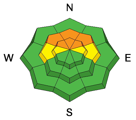
bottom line Areas of CONSIDERABLE danger exist in localized terrain on steep northwest to north to northeasterly facing slopes at the mid and upper elevations. Human triggered avalanches 1-3' deep are possible and may be triggered from below. Lingering wind slabs may still be triggered in steep wind drifted terrain and more commonplace in areas with an easterly component. Careful snowpack evaluation, cautious route-finding and conservative decision making remains essential today. The Good News: excellent and safer skiing and riding conditions can be found on non-wind loaded southerly aspects. If headed to northerly terrain, the smart money stays on low angle slopes with no overhead hazard (ie-connected to steeper slopes above or adjacent to you).
|
 |
special announcement We have discount lift tickets for Alta, Snowbird, Brighton, Solitude, Snowbasin,and Beaver Mountain. Details and order information here. All proceeds from these go towards paying for avalanche forecasting and education! |
 |
current conditions Skies are partly cloudy with winds out of the west-southwest blowing 10mph, gusting to 15. Mountain temperatures are the coldest of the season. It's Ice Station Zebra with temps down to -5°F along the ridgelines and as low as -10°F at the Spruces trailhead in mid-BCC. The wind chill registers as -24°F along the exposed ridgelines. Skiing and riding conditions are much improved and coverage now sits at 65-80" in the higher elevations of the Cottonwoods and the PC ridgeline.
|
 |
recent activity Avalanche activity reported from yesterday:
My own party experienced two very large, loud, resounding collapses and triggered a part of the hangfire while investigating Monday's close call in Toots-To-Boot in Alexander Basin of Mill Creek. Below ski guide and avalanche educator Allison Conover explains what we found at the slide. (YouTube link) |
| type | aspect/elevation | characteristics |
|---|

|
|
LIKELIHOOD
 LIKELY
UNLIKELY
SIZE
 LARGE
SMALL
TREND
 INCREASING DANGER
SAME
DECREASING DANGER
|
|
description
There's too much uncertainty. Two to three inches of snow-water-equivalent over the past week and strong southerly pre-frontal winds Saturday night into Sunday have clearly stressed - at the very least - thinner snowpack areas or areas that have avalanched previously this winter. At least five avalanches - some natural, some human triggered - have stepped into older faceted snow the last two days (Toots, Davis Gulch, West Monitor, mid-LCC control work, skier remote in the Provo mountains - all northwest through east). Loud, deep, guttural collapsing of these layers continued into yesterday, offering little reassurance of, well, much. Monday's Toots-To-Boot avalanche very well demonstrates the mercurial character of a persistent slab avalanche. The very experienced party skied on low thirty-degree terrain and it wasn't until the second person on the slope skied that it propagated back up and across the landscape to where the terrain reached the 44° steep headwall, pulling the whole thing down 300' wide. Standing just off to the side, the first skier watched the slide roar down, coming within 10' feet from where he was standing. Spatial variability exists across the range and across the slope. Areas most suspect are drainages of Mill Creek canyon, the Park City ridgeline, Summit Park, Mt Aire, Snake Creek - all areas along the periphery of the Cottonwoods. This is not to say the Cottonwood get the hall-pass; it's just that many riders may be able to get away with more...until they can't anymore. This structure showed its cards with noticeable stress cracks as low in 8500' . Slope-scale, the strength and structure can vary widely and wildly across the slope - many areas we dug near the Toots avalanche were not that alarming. |
| type | aspect/elevation | characteristics |
|---|

|

|
LIKELIHOOD
 LIKELY
UNLIKELY
SIZE
 LARGE
SMALL
TREND
 INCREASING DANGER
SAME
DECREASING DANGER
|
|
description
Lingering wind drifts may stll be sensitive to human weight in steep wind loaded terrain and most pronounced on north to east to south facing slopes that may have been loaded or cross-loaded beyond ridgelines and other terrain features. |
 |
weather We'll see increasing clouds with the first of many generally weak weather systems on tap for northern Utah. For today, winds will be from the south and southwest at 10-15mph. Temps will generally remain in the freezer for awhile...today they'll be in the single digits up high and the low teens at the mid-elevations. Saturday night into Sunday holds the best promise for additional snowfall. |
| general announcements CLICK HERE FOR MORE GENERAL INFO AND FAQ The UAC has new support programs with Outdoor Research and Darn Tough. Support the UAC through your daily shopping. When you shop at Smith's, or online at Outdoor Research, REI, Backcountry.com, Darn Tough, Patagonia, NRS, Amazon, eBay a portion of your purchase will be donated to the FUAC. See our Donate Page for more details on how you can support the UAC when you shop. Benefit the Utah Avalanche Center when you buy or sell on eBay - set the Utah Avalanche Center as a favorite non-profit in your eBay account here and click on eBay gives when you buy or sell. You can choose to have your seller fees donated to the UAC, which doesn't cost you a penny This information does not apply to developed ski areas or highways where avalanche control is normally done. This advisory is from the U.S.D.A. Forest Service, which is solely responsible for its content. This advisory describes general avalanche conditions and local variations always occur. |