25th Annual Black Diamond Fall Fundraising Party
Thursday, September 13; 6:00-10:00 PM; Black Diamond Parking Lot
25th Annual Black Diamond Fall Fundraising Party
Thursday, September 13; 6:00-10:00 PM; Black Diamond Parking Lot
| Advisory: Salt Lake Area Mountains | Issued by Mark Staples for Tuesday - February 20, 2018 - 6:12am |
|---|

|
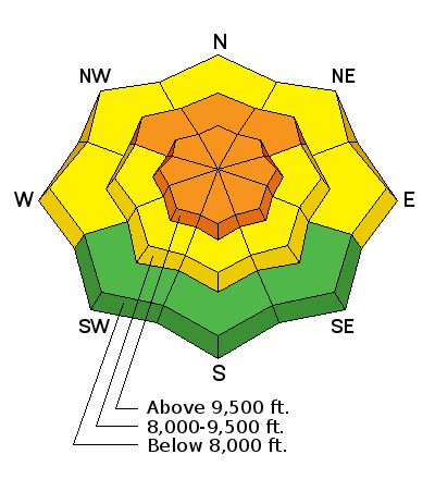
bottom line Today the avalanche danger is CONSIDERABLE on upper elevation slopes for wind slabs and persistent slab avalanches. It is also CONSIDERABLE at mid elevations on NW, N, and NE facing slopes for persistent slab avalanches. Watch for any fresh wind loading which will make avalanches more likely, and go to southerly facing slopes to avoid the persistent slab avalanche problem.
|
 |
special announcement We have discount lift tickets for Alta, Snowbird, Brighton, Solitude, Snowbasin,and Beaver Mountain. Details and order information here. All proceeds from these go towards paying for avalanche forecasting and education! |
 |
current conditions Winter continues and it's great to see. Overnight 2-4 inches of very low density snow fell in the upper Cottonwood Canyons while other places recieved 1-2 inches. A few more inches has likely fallen this morning as an band of lake-effect snowfall was passing over the valley. Storm totals are 14-22 inches of snow (1-1.6 inches of snow water equivalent). Yesterday this snow was reported to be slightly upside down, meaning that it was slightly denser on top and lighter underneath. The storm snow has settled a bit since yesterday and should be fairly consistent today with a few inches of fluff on top. Temperatures are generally a few degrees above zero F at trailheads and a few degrees below zero near ridgetops. Winds at ridgetops are averging 10 mph and gusting 15-20 mph. They blew from the NW yesterday and are westerly this morning. There has been some wind transport and wind drifting of the new snow which is easy because the snow is so light; however, this wind transport has mostly been confined to ridgetops and hasn't been too significant. |
 |
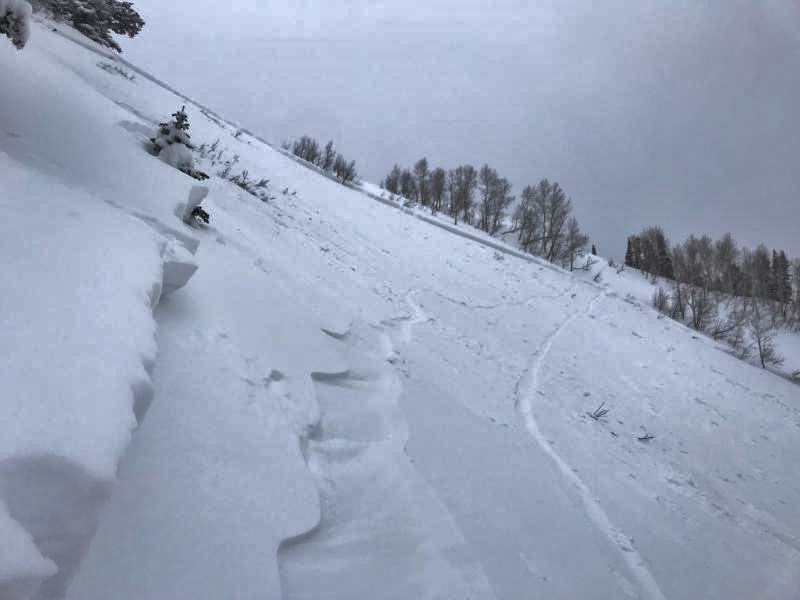
recent activity Yesterday there was a natural avalanche cycle involving the new snow around 0300 during intense snowfall. Later that morning ski patrols easily triggered many storm snow avalanches that were both soft slabs and dry loose avalanches with ski cuts and explosives. Backcountry skiers in Mill Creek Canyon reported sluffs on steep slopes involving the upper 2-4 inches of snow. There were two notable avalanches involving older layers of snow yesterday. One occurred in Alexander Basin (above Mill Creek Canyon) north of Gobblers Knob. This slide happened on a NE aspect at 9400 feet and it broke near an ice crust just below snow that fell last Thursday. It was skier triggered but no one was caught and it broke 200 feet wide. Read more about it here and see the photo below (Gustafson photo)
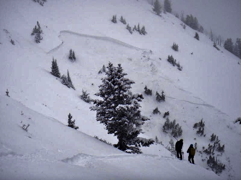
Another occurred on a westerly aspect in Davis Gulch on Gobblers Knob. It broke 3 feet deep and 80 feet wide. A skier triggered sluff triggered a soft storm slab which then triggered this avalanche. (Grainger, Young, Olafsen photo).
|
| type | aspect/elevation | characteristics |
|---|

|

|
LIKELIHOOD
 LIKELY
UNLIKELY
SIZE
 LARGE
SMALL
TREND
 INCREASING DANGER
SAME
DECREASING DANGER
|
|
description
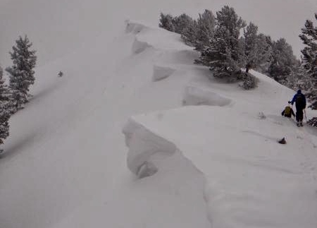
Winds are the main weather factor to watch out for today because the new snow can easily be transported. Even though winds are not too strong, they are transporting some snow at ridgetops and upper elevations with westerly winds at 11,000 feet averaging 25 mph this morning from the W. The slightest wind loading will make avalanches in the new snow more likely. The photo below shows a prime location for wind slabs just under cornices (Grainger, Young, Olafsen photo) Don't let your guard down on non-wind loaded slopes. The potential for storm slabs and dry loose avalanches is much less compared to yesterday, but they remain a possibility.
|
| type | aspect/elevation | characteristics |
|---|

|

|
LIKELIHOOD
LIKELY
UNLIKELY
SIZE
 LARGE
SMALL
TREND
INCREASING DANGER
SAME
DECREASING DANGER
|
|
description
The combined weight of yesterday's storm, last Thursday's storm, and a few other smaller ones last week is about 3 inches of snow water equivalent. Half of this weight fell in yesterday's storm. I'm honestly not sure how widespread or how reactive the persistent slab avalanche problem will be. What I do know is:
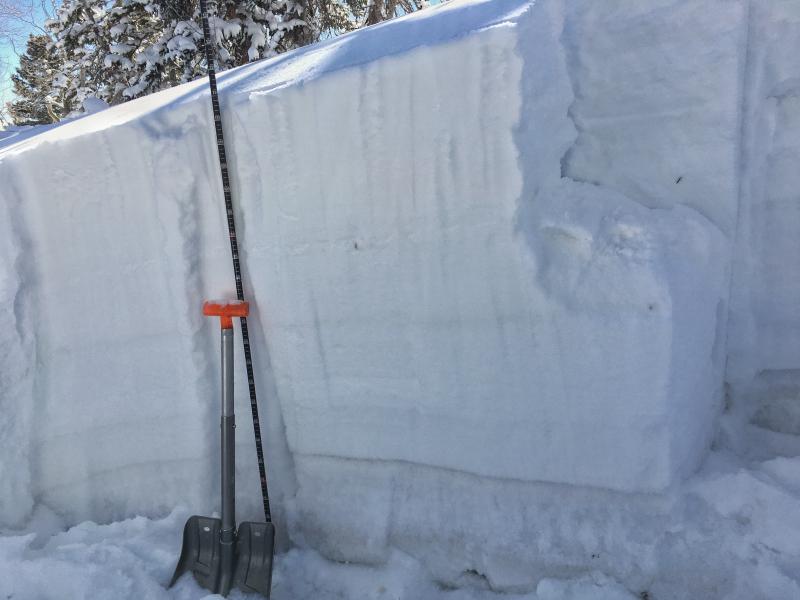
The best way to avoid this problem is ride southerly facing slopes. The good news is that the snowpack is getting deeper and this helps it get stronger over time. The other good news is that clouds and cold weather will help maintain great snow conditions on southerly aspects. Photo below shows facets near the bottom of the snowpack and they are easy to see by the dark horizontal line where this column fractured.
The next photo shows an ice crust (horizontal stripe) with some faceted snow that is just under the snow that fell on Thursday. This layer may have been the one responsible for yesterday's avalanche near Alexander Basin.
|
 |
weather A band of lake effect snowfall moved over the area this morning. The lake effect snowfall will end but there should be some snowflakes in the air today. Skies will be mostly cloudy this morning and slowly breaking up this afternoon when some sunshine may appear. Overall conditions will remain cold, with mountain temperatures struggling to reach 10 degrees F. Winds at ridgetops will remain westerly and blow 5-15 mph with gusts of 25 mph. Winds around 11,000 feet will blow 10-20 mph. |
| general announcements CLICK HERE FOR MORE GENERAL INFO AND FAQ The UAC has new support programs with Outdoor Research and Darn Tough. Support the UAC through your daily shopping. When you shop at Smith's, or online at Outdoor Research, REI, Backcountry.com, Darn Tough, Patagonia, NRS, Amazon, eBay a portion of your purchase will be donated to the FUAC. See our Donate Page for more details on how you can support the UAC when you shop. Benefit the Utah Avalanche Center when you buy or sell on eBay - set the Utah Avalanche Center as a favorite non-profit in your eBay account here and click on eBay gives when you buy or sell. You can choose to have your seller fees donated to the UAC, which doesn't cost you a penny This information does not apply to developed ski areas or highways where avalanche control is normally done. This advisory is from the U.S.D.A. Forest Service, which is solely responsible for its content. This advisory describes general avalanche conditions and local variations always occur. |