25th Annual Black Diamond Fall Fundraising Party
Thursday, September 13; 6:00-10:00 PM; Black Diamond Parking Lot
25th Annual Black Diamond Fall Fundraising Party
Thursday, September 13; 6:00-10:00 PM; Black Diamond Parking Lot
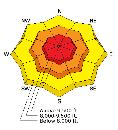
| Advisory: Salt Lake Area Mountains | Issued by Mark Staples for Monday - February 19, 2018 - 6:35am |
|---|

|
bottom line The avalanche danger is HIGH at upper elevations and CONSIDERABLE at mid elevations. Storm slab avalanches are very likely and travel in avalanche terrain is not recommended. Winds may increase later today from the NW and exacerbate this problem. Additionally this load of new snow will stress deeper layers of snow and persistent slab avalanches are likely at mid and upper elevations on NW, N and NE facing slopes.
|
 |
special announcement This morning BACKCOUNTRY CLOSURES ARE IN EFFECT. The north side of Little Cottonwood Canyon is closed from 4am to 8am from Lisa Falls to Grizzly Gulch. White Pine TH open to the south. The Canyons Village/Park City Ski Patrol will be conducting avalanche mitigation work in the Daybreak and McDonalds area today which will be closed. |
 |
current conditions Welcome back winter! This morning a foot of snow had fallen in most areas as of 6 a.m. with 13-16 inches at upper elevations in the Cottonwood Canyons and the PC Ridgeline. Snowfall was most intense from 9 p.m last night until 2 a.m. It’s relatively calm and cold. This morning winds shifted to the NW and were blowing 5-10 mph gusting 10-15 mph. Temperatures are mostly in teens F and single digits above 10,000 feet. Image below from 6:30 a.m. from a web cam at Snowbird shows 16 inches of new snow.
|
 |
recent activity At least a dozen natural avalanches occurred on the north side of the Little Cottonwood Canyon road from 9 p.m. and 2 a.m. during intense snowfall. These probably only involved the new snow. Avalanches likely occurred in many other places during that time but we don't know about them yet. No avalanches were reported yesterday during the day. |
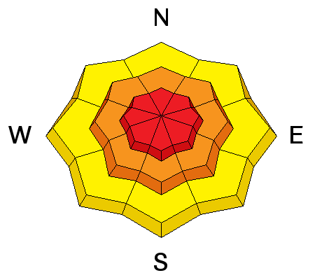
| type | aspect/elevation | characteristics |
|---|

|
|
LIKELIHOOD
 LIKELY
UNLIKELY
SIZE
 LARGE
SMALL
TREND
 INCREASING DANGER
SAME
DECREASING DANGER
|
|
description
Storm slab avalanches are likely and travel in avalanche terrain is not recommended. The surest sign of unstable conditions is recent avalanche activity which happened overnight and early this morning. Additionally, dry loose avalanches are likely with such light snow. Later today winds could start to increase from the NW. They will easily transport today’s light snow and wind slabs could become a problem as well. Even if winds don't make big obvious wind slabs, they could transport just enough snow to keep storm slab avalanches likely. These storm slab avalanches may also break under snow from last Thursday's storm near a thin ice crust that may have some facets and/or graupel snow under it. See the photo below of this layer I found yesterday in Days Fork. It has been found in other places.
|
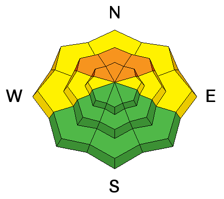
| type | aspect/elevation | characteristics |
|---|

|
|
LIKELIHOOD
 LIKELY
UNLIKELY
SIZE
 LARGE
SMALL
TREND
INCREASING DANGER
SAME
DECREASING DANGER
|
|
description
I am very nervous about avalanches breaking deeper in the snowpack on NW, N and NE facing slopes. Three weather factors have raised the danger for this avalanche problem today:
Yesterday my partner and I found two small persistent slab avalanches in Days Fork (Days Draw) that had been skier triggered in areas with a thin snowpack. These slides told me that with today's rapid, heavy load of new snow, larger persistent slab avalanches are likely. Triggering these types of avalanches will be easist in areas with snow less deep than the length of a ski pole. Once started in shallow areas, they could quickly propagate into areas with deeper snow. Overall, there is a lot of uncertainty with how the snowpack will react to this loading and which slopes will avalanche and which will not. We'll learn more in the next few days. |
 |
weather On and off snowfall today should bring another 3-6 inches of very low density snow. Winds may increase from the NW later today and blow 10-20 mph. Temperatures will remain cold and may only rise a few degrees from where they are this morning. Tonight temperatures will get even colder and should drop below 0 F. Snowfall should be over by Tuesday and mountain temperatures may not rise above the single digits F. Temperatures will remain cold only be slightly warmer for most of the week. |
| general announcements CLICK HERE FOR MORE GENERAL INFO AND FAQ The UAC has new support programs with Outdoor Research and Darn Tough. Support the UAC through your daily shopping. When you shop at Smith's, or online at Outdoor Research, REI, Backcountry.com, Darn Tough, Patagonia, NRS, Amazon, eBay a portion of your purchase will be donated to the FUAC. See our Donate Page for more details on how you can support the UAC when you shop. Benefit the Utah Avalanche Center when you buy or sell on eBay - set the Utah Avalanche Center as a favorite non-profit in your eBay account here and click on eBay gives when you buy or sell. You can choose to have your seller fees donated to the UAC, which doesn't cost you a penny This information does not apply to developed ski areas or highways where avalanche control is normally done. This advisory is from the U.S.D.A. Forest Service, which is solely responsible for its content. This advisory describes general avalanche conditions and local variations always occur. |


