25th Annual Black Diamond Fall Fundraising Party
Thursday, September 13; 6:00-10:00 PM; Black Diamond Parking Lot
25th Annual Black Diamond Fall Fundraising Party
Thursday, September 13; 6:00-10:00 PM; Black Diamond Parking Lot
| Advisory: Salt Lake Area Mountains | Issued by Drew Hardesty for Sunday - February 11, 2018 - 5:46am |
|---|

|
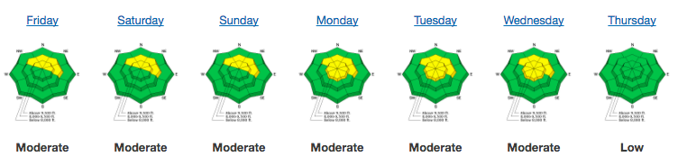
bottom line Most terrain continues with LOW danger. A MODERATE danger for new snow instabilities, however, exists in the higher elevations for shallow wind slabs and longer running dry....and then possibly wet sluffs. Remember that risk is amplified by your terrain choices. As an outlier, human triggered avalanches 1-3' deep are unlikely but not impossible in isolated terrain. Many experienced people continue to avoid steep slopes facing north through northeast at the mid and upper elevations - particularly if the slope offers a poor runout.
|
 |
special announcement The UAC Marketplace is still open. Our online marketplace still has deals on skis, packs, airbag packs, beacons, snowshoes, soft goods and much more. Benefit the Utah Avalanche Center when you buy or sell on eBay - set the Utah Avalanche Center as a favorite non-profit in your eBay account here and click on eBay gives when you buy or sell. You can choose to have your seller fees donated to the UAC, which doesn't cost you a penny |
 |
current conditions It'll be nothing short of glorious in the mountains today. Skies are clear and with the passing of the cold front, mountain temperatures have plummeted to the single digits. In many cases, overnight lows are twenty and even thirty degrees lower than they were 48 hours ago. Winds are northwesterly, blowing 15mph, gusting to 20. Along the 11,000' ridgelines, winds are 25mph with gusts to 30. Under promise and over deliver. This "Little Storm That Could" produced 4-7" of 6% density snow with water equivalent amounts of 0.2-.0.4". Riding conditions have again improved, although they'll be a bit scratchy underneath on some of the steeper lines. Our Week in Review for February 2-8:
Year in Review. Back in mid to late December, we took stock of our thin snowpack and how it may play a role in avalanche conditions for the winter. Since then, we've had many many very close calls involving very experienced individuals. And now, almost two months later, how is our winter stacking up? Jim Steenburgh, in his highly recommended blog Wasatch Weather Weenies, brings us up to date. (Teaser: we sit firmly in 2nd place after the disastrous winter of 76/77.) |
 |
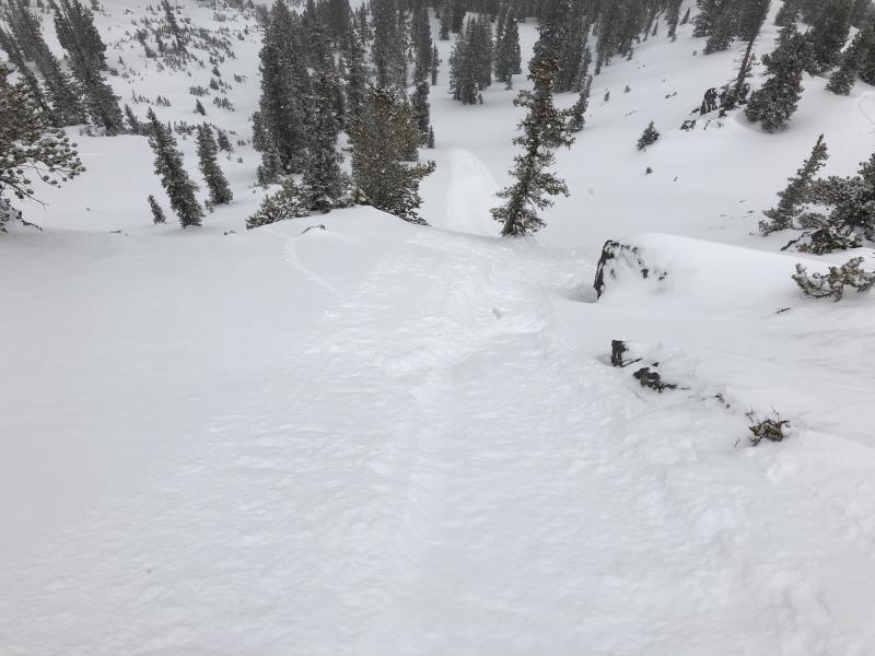
recent activity Ski area control teams found shallow soft slabs 3-6" deep by late in the day. Minor sluffing also noted (Gagne pic)
|
| type | aspect/elevation | characteristics |
|---|

|
|
LIKELIHOOD
 LIKELY
UNLIKELY
SIZE
 LARGE
SMALL
TREND
 INCREASING DANGER
SAME
DECREASING DANGER
|
|
description
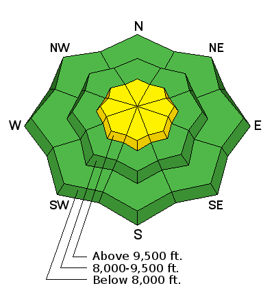
Shallow wind slabs will be found along the highest elevations. I expect them to be neither deep nor wide, but rather pockety and sensitive and tucked into the lee of classic terrain features: beyond ridges and subridges and lee of rocky outcroppings and other micro-terrain features. These should be confined to the higher, more exposed elevations. |
| type | aspect/elevation | characteristics |
|---|

|

|
LIKELIHOOD
LIKELY
UNLIKELY
SIZE
LARGE
SMALL
TREND
 INCREASING DANGER
SAME
DECREASING DANGER
|
|
description
Dry sluffs will run with provocation on the steepest terrain. I expect them to run fast and far, particularly on the underlying slick crusts on the east to south to westerly aspects. These should be easy to mitigate with ski cuts by experienced practitioners, but remember that if you're heading into steep, confined couloirs, there's often no place to run, no place to hide. Wet sluffs. With direct sun and warming aloft today, human triggered wet sluffs may also be expected in the steep sunny terrain. This may not be a problem until midday, but you'll know it when you see (and feel) it. |
| type | aspect/elevation | characteristics |
|---|

|
|
LIKELIHOOD
 LIKELY
UNLIKELY
SIZE
 LARGE
SMALL
TREND
INCREASING DANGER
SAME
DECREASING DANGER
|
|
description
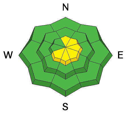
The persistent slab instability has mostly gone dormant, yet few of us are enamored with the structure. On Friday, my partner and I backed off a steep upper elevation slope in Broads Fork of BCC. I felt that it probably wouldn't slide, but "probable" wasn't good enough. We simply backed off and chose more forgiving terrain. The structure is most suspect on north to northeast facing slopes above about 9000'. Greg well describes what he saw in Days Fork yesterday here. |
 |
weather Under clear skies, moutain temperatures should reach into the low 20s at 10,000' and the mid-30s at 8500'. Winds will start to back to the southwest at 15mph, but may reach 20-25mph hourly averages by late afternoon. Another weak system moves through tomorrow afternoon/eve and again later Wednesday with some more promise over the late weekend. |
| general announcements CLICK HERE FOR MORE GENERAL INFO AND FAQ The UAC has new support programs with Outdoor Research and Darn Tough. Support the UAC through your daily shopping. When you shop at Smith's, or online at Outdoor Research, REI, Backcountry.com, Darn Tough, Patagonia, NRS, Amazon, eBay a portion of your purchase will be donated to the FUAC. See our Donate Page for more details on how you can support the UAC when you shop. Benefit the Utah Avalanche Center when you buy or sell on eBay - set the Utah Avalanche Center as a favorite non-profit in your eBay account here and click on eBay gives when you buy or sell. You can choose to have your seller fees donated to the UAC, which doesn't cost you a penny This information does not apply to developed ski areas or highways where avalanche control is normally done. This advisory is from the U.S.D.A. Forest Service, which is solely responsible for its content. This advisory describes general avalanche conditions and local variations always occur. |